Roblin Park
Roblin Park is one of the original neighbourhoods of the Charleswood community in Winnipeg, Manitoba, Canada.[1][2] It is bounded by Roblin Boulevard to the North, Hartestone Road to the East, bisects the Harte Trail to the south and Scotswood Drive to the West.
Roblin Park | |
|---|---|
Neighbourhood | |
 | |
| Coordinates: 49°51′10″N 97°17′21″W | |
| Country | |
| Province | |
| City | Winnipeg |
| Area | Charleswood |
| Initial Settlement | 1912 |
| Veterans Settlement Plan | 1946 |
| Founded by | Veterans' Land Act |
| Population | |
| • Total | 945 |
| • Density | 1.35/km2 (3.5/sq mi) |
| Architect | Moody and Moore |
| Builder | Bird Construction Ltd. |
It is served by the Roblin Park Community Centre.[2]
Roblin Park is part of the Assiniboine South Neighbourhood Cluster. It is part of the Winnipeg electoral ward of Charleswood - Tuxedo - Westwood, the provincial electoral district of Roblin and the federal riding of Charleswood—St. James—Assiniboia—Headingley.
History
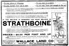
The area was originally named Strathboine, and was slated for development in 1912. However the initial development failed to attract residents due to its remoteness and the collapse of development.[1]
The failed settlement was purchased by the Veterans Land Act in 1945. Roblin Park was set up as a housing development for Veterans in the mid-1940s.[1]
In 1946, Joseph and Violet Reynolds became the first to move into Roblin Park, at 105 (now 605) Pepperloaf Crescent.[1]
Demographics
The neighbourhood is predominantly white, middle class and anglophone. According to the 2016 Census, the neighbourhood is 89.5% Anglophone.[3] The neighbourhood is majority white, with the largest non-white ethnic groups being Indigenous or Metis (7.4%) and the remaining 4.2% of residents belonging to other visible minorities.[3]
The average income of the neighbourhood is $58,661, higher than the city average of $44,915.[3]
Amenities
Roblin Park is home to the Roblin Park Community Centre. It has an outdoor hockey rink. Roblin Park also covers a portion of the Harte Trail; a multi-use trail that is part of the Trans-Canada Trail.
References
- https://www.winnipegarchitecture.ca/wp-content/uploads/2020/07/5-Roblin-Park.pdf
- "Roblin Park Community Centre". rpcc. Retrieved 2021-06-28.
- Winnipeg, City of. "Winnipeg.ca (UD) : 2016 Census". legacy.winnipeg.ca. Retrieved 2023-06-04.