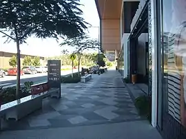
Ripley, Queensland
Ripley is a suburb in the City of Ipswich, Queensland, Australia.[2] In the 2016 census, Ripley had a population of 1,405 people.[1]
| Ripley Ipswich, Queensland | |||||||||||||||
|---|---|---|---|---|---|---|---|---|---|---|---|---|---|---|---|
 Ripley Town Centre | |||||||||||||||
 Ripley | |||||||||||||||
| Coordinates | 27.6727°S 152.7827°E | ||||||||||||||
| Population | 1,405 (2016 census)[1] | ||||||||||||||
| • Density | 109.8/km2 (284.3/sq mi) | ||||||||||||||
| Postcode(s) | 4306 | ||||||||||||||
| Area | 12.8 km2 (4.9 sq mi) | ||||||||||||||
| Time zone | AEST (UTC+10:00) | ||||||||||||||
| Location |
| ||||||||||||||
| LGA(s) | City of Ipswich | ||||||||||||||
| State electorate(s) | Ipswich | ||||||||||||||
| Federal division(s) | Blair | ||||||||||||||
| |||||||||||||||
Geography
The eastern boundary of Ripley is aligned with Bundamba Creek. The Centenary Highway passes through the south east corner of Ripley. Ripley is located within the Ripley Valley,[3] and takes its name from the valley.
History
Ripley is situated in the Yugarabul traditional Indigenous Australian country. [4][5]
The historical settlement of Ripley dates back to the mid-1800s as a farming community.[6]
Bundamba Upper State School opened on 2 February 1874. In 1909, it was renamed Ripley State School. It closed in 1930 due to low student numbers.[7] It was at 1166-1176 Ripley Road in neighbouring South Ripley.[8]
Cityhope Church was built in 1998 by a congregation established in Ipswich in the mid 1960s.[9]
In 2007 it was announced that Ripley would be a master-planned urban development.[10]
In the 2016 census, Ripley had a population of 1,405 people.[1]
Ripley urban development
The Ripley area is part of the Brisbane metropolitan western growth corridor project. The development, known as Ecco Ripley is in response to the local and state governments' solicitation for land releases to alleviate expected and forecasted population growth from the general population growth of the existing communities, as well as growth from interstate and overseas migration.[11][12]
Once the area is fully developed, the Ripley district is expected to have a population of 120,000 people with an estimated 50,000 residential dwellings. The city development will provide employment with 200,000 job positions estimated. The Ripley development is in proximity of the suburbs and areas within the western growth corridor and Ripley district, such as South Ripley, Swanbank, Deebing Heights and White Rock, with suitable land for new residential, business and industrial developments.[13]
The development is to be the country's largest planned community.[14]
Transport
Ripley is serviced by bus route 531 between Springfield Central and Yamanto.[15]
Planned transportation links includes an extension of the Springfield railway line to Ipswich, and commuter railway stations between Ipswich and Springfield.[16]
Education
A government primary school named Ripley Central State School had opened in Ripley for Term 1 in January, 2023, situated on Binnies Road. The school had undergone proposal and planning prior to construction, including approval by the Ipswich City Council.[17] Ripley Valley State School and Ripley Valley State Secondary College are located in the adjacent suburb of South Ripley. [18]
Amenities
Cityhope Church is at 7 Rex Hills Drive (27.6576°S 152.7808°E). It is affiliated with the Australian Christian Churches.[19][20]
References
- Australian Bureau of Statistics (27 June 2017). "Ripley (SSC)". 2016 Census QuickStats. Retrieved 20 October 2018.
- "Ripley – suburb in City of Ipswich (entry 48381)". Queensland Place Names. Queensland Government. Retrieved 13 February 2022.
- "Ripley Valley – valley (entry 44029)". Queensland Place Names. Queensland Government. Retrieved 22 June 2017.
- "Yuggera and Ugarapul People and Ipswich City Indigenous Land Use Agreement (ILUA)". ATNS. Archived from the original on 23 July 2020. Retrieved 24 July 2020.
- "AIATSIS code E66: Yugarabul". Federal government. Australian Institute of Aboriginal and Torres Strait Islander Studies. Archived from the original on 13 August 2020. Retrieved 31 July 2020.
- "Ripley Valley's rich past revealed". Ipswich First. 6 March 2018. Archived from the original on 7 April 2019. Retrieved 23 February 2022.
- Queensland Family History Society (2010), Queensland schools past and present (Version 1.01 ed.), Queensland Family History Society, ISBN 978-1-921171-26-0
- "Moreton 40 Chain map AG2 series sheet 2 south" (Map). Queensland Government. 1922. Archived from the original on 23 February 2022. Retrieved 23 February 2022.
- "About". Cityhope Church. Archived from the original on 3 March 2021. Retrieved 23 February 2022.
- "Ipswich council unveils major pre-planned community project". ABC News. 25 May 2007. Archived from the original on 26 October 2020. Retrieved 26 March 2020.
- "Ripley Valley - The Western Corridor". Archived from the original on 19 July 2008. Retrieved 22 June 2017.
- "Monash University Research Repository - People and Place". Archived from the original on 19 July 2011. Retrieved 22 June 2017.
- "Ripley Valley". Ipswich City Council. Archived from the original on 3 March 2011. Retrieved 22 June 2017.
- "Ipswich council unveils major pre-planned community project". 25 May 2007. Archived from the original on 23 February 2022. Retrieved 22 June 2017.
- Roads, TransLink Division, Department of Transport and Main. "Route 531 | TransLink". TransLink Division, Department of Transport and Main Roads. Archived from the original on 14 February 2022. Retrieved 14 February 2022.
{{cite web}}: CS1 maint: multiple names: authors list (link) - "Ipswich to Springfield Public Transport Corridor Study". 24 July 2019. Archived from the original on 15 July 2020. Retrieved 30 May 2020.
- Jin, Hui (25 January 2023). "New schools set to welcome local students for the first time". Ipswich News Today. Retrieved 26 January 2023.
- "NEW SCHOOL PLANNED FOR IPSWICH IN RIPLEY VALLEY ESTATE". Ripley Town Centre. 14 September 2021. Archived from the original on 23 February 2022. Retrieved 26 January 2022.
- "Cityhope Church". Cityhope Church. Archived from the original on 22 December 2021. Retrieved 23 February 2022.
- Blake, Thom. "Cityhope Church". Queensland religious places database. Archived from the original on 23 February 2022. Retrieved 23 February 2022.
Further reading
- Lamb, Pamela (2015), In the shadow of Mount Flinders : stories of Ripley Valley, Bellbird Park, Qld.: Agneau Press