Resorts of Suriname
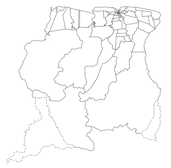
The ten districts of Suriname are divided into 63 resorts (Dutch: ressorten). Within the capital city of Paramaribo, a resort entails a neighbourhood; in other cases it is more akin to a municipality, consisting of a central place with a few settlements around it. The resorts in the Sipaliwini District are especially large, since the interior of Suriname is sparsely inhabited.
 |
|---|
| Constitution |
|
|
The average resort is about 2,600 square kilometres (1,000 sq mi) and has almost 8,000 inhabitants. According to article 161 of the Constitution of Suriname, the highest political body of the resort is the resort council. Elections for the resort council are held every five years and are usually at the same time as the Suriname general elections.
Overview map
List of resorts
The resorts are listed below, according to district.[1]
Brokopondo District
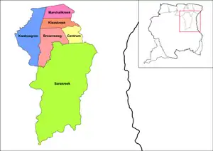
The Brokopondo District consists of the following resorts:
| Resort | Area in km2 | Population density | Population (2012) |
|---|---|---|---|
| Kwakoegron | 1,050 | 0.2 | 263 |
| Marshallkreek | 354 | 2.8 | 1,171 |
| Klaaskreek | 349 | 3.8 | 2,124 |
| Centrum | 314 | 9.1 | 4,482 |
| Brownsweg | 731 | 5.3 | 4,783 |
| Sarakreek | 4,566 | 1.1 | 3,076 |
Commewijne District
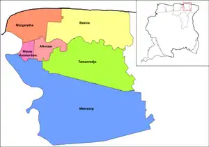
The Commewijne District consists of the following resorts:
| Resort | Area in km2 | Population density | Population (2012) |
|---|---|---|---|
| Margaretha | 191 | 4.1 | 756 |
| Bakkie | 440 | 1.2 | 447 |
| Nieuw Amsterdam | 48 | 114.4 | 5,650 |
| Alkmaar | 81 | 52.0 | 5,561 |
| Tamanredjo | 512 | 10.8 | 6,601 |
| Meerzorg | 1,081 | 7.5 | 12,405 |
Coronie District

The Coronie District consists of the following resorts:
| Resort | Area in km2 | Population density | Population (2012) |
|---|---|---|---|
| Welgelegen | 2,143 | 0.3 | 593 |
| Totness | 173 | 9.7 | 2,150 |
| Johanna Maria | 1,586 | 0.4 | 648 |
Marowijne District
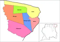
The Marowijne District consists of the following resorts:
| Resort | Area in km2 | Population density | Population (2012) |
|---|---|---|---|
| Moengo | 1,117 | 8.6 | 10,834 |
| Wanhatti | 461 | 0.8 | 466 |
| Galibi | 1,014 | 0.7 | 741 |
| Moengo Tapoe | 455 | 0.9 | 579 |
| Albina | 397 | 12.9 | 5,247 |
| Patamacca | 1,183 | 0.4 | 427 |
Nickerie District
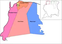
The Nickerie District consists of the following resorts:
| Resort | Area in km2 | Population density | Population (2012) |
|---|---|---|---|
| Wageningen | 1,613 | 2.1 | 2,937 |
| Groot Henar | 2,185 | 1.6 | 2,709 |
| Oostelijke Polders | 357 | 19.0 | 7,153 |
| Nieuw Nickerie | 30 | 461.4 | 12,818 |
| Westelijke Polders | 1,168 | 7.7 | 8,616 |
Para District
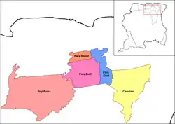
The Para District consists of the following resorts:
| Resort | Area in km2 | Population density | Population (2012) |
|---|---|---|---|
| Para Noord | 236 | 27.3 | 9,703 |
| Para Oost | 446 | 16.5 | 8,016 |
| Para, Zuid | 909 | 4.8 | 6,113 |
| Bigi Poika | 2,361 | 0.1 | 525 |
| Carolina | 1,441 | 0.2 | 343 |
Paramaribo District
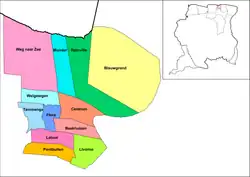
The Paramaribo District consists of the following resorts:
| Resort | Area in km2 | Population density | Population (2012) |
|---|---|---|---|
| Blauwgrond | 43 | 661.3 | 31,483 |
| Rainville | 31 | 930.7 | 22,747 |
| Munder | 14 | 1146.4 | 17,234 |
| Centrum | 9 | 3252.7 | 20,631 |
| Beekhuizen | 6 | 3297.2 | 17,185 |
| Weg naar Zee | 41 | 321.3 | 16,037 |
| Welgelegen | 7 | 3387.0 | 19,304 |
| Tammenga | 6 | 2385.5 | 15,819 |
| Flora | 4 | 3836.5 | 19,538 |
| Latour | 6 | 4358.0 | 29,526 |
| Pontbuiten | 6 | 3246.2 | 23,211 |
| Livorno | 9 | 931.8 | 8,209 |
Saramacca District
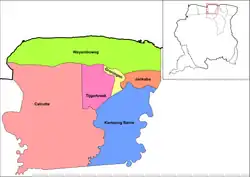
The Saramacca District consists of the following resorts:
| Resort | Area in km2 | Population density | Population (2012) |
|---|---|---|---|
| Calcutta | 1,655 | 1.2 | 1,647 |
| Tijgerkreek | 241 | 12.0 | 3,244 |
| Groningen | 57 | 49.6 | 2,818 |
| Kampong Baroe | 684 | 2.8 | 2,248 |
| Wayamboweg | 872 | 1.8 | 1,560 |
| Jarikaba | 127 | 37.9 | 5,963 |
Sipaliwini District
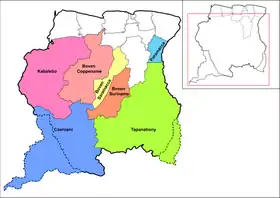
On 11 September 2019,[2] a new resort was created out of Tapanahony, and is called Paramacca. The Paramacca resort is the northern part of Tapanahony, and mainly inhabited by the Paramaccan people.[3][2]
The Sipaliwini District consists of the following resorts:
| Resort | Area in km2 | Population density | Population (2012) |
|---|---|---|---|
| Tapanahony | 38,965[4] | 0.3 | 13,808 |
| Boven Suriname | 7,512 | 2.0 | 17,957 |
| Boven Saramacca | 5,929 | 0.3 | 1,427 |
| Boven Coppename | 15,839 | 0.0 | 539 |
| Kabalebo | 25,955 | 0.1 | 2,291 |
| Coeroeni | 33,133 | 0.0 | 1,048 |
| Paramacca | 3,233[4] | ~0.5 | 1,500-2,000[5] |
Wanica District
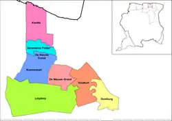
The Wanica District consists of the following resorts:
| Resort | Area in km2 | Population density | Population (2012) |
|---|---|---|---|
| Kwatta | 62 | 162.8 | 14,151 |
| Saramacca Polder | 28 | 278.2 | 10,217 |
| Koewarasan | 71 | 227.6 | 27,713 |
| De Nieuwe Grond | 38 | 532.1 | 26,161 |
| Lelydorp | 149 | 107.0 | 18,663 |
| Houttuin | 58 | 176.3 | 15,656 |
| Domburg | 37 | 150.1 | 5,661 |
See also
References
- The statistics from this section are from the eighth census of 2012, accessible at the General Bureau of Statistics of Suriname website: Censusstatistieken 2012
- "Paamaka en Ndyuka leggen grens vast". Regional Development.gov.sr (in Dutch). Retrieved 23 May 2020.
- "Distrikt Sipaliwini 1". Suriname.nu (in Dutch). Retrieved 23 May 2020.
- "Planning Office Suriname - Districts" (PDF). Planning Office Suriname (in Dutch). Retrieved 23 May 2020.
- "Dc Malontie: 'Paamaka op weg naar ontwikkeling'- Sneak Peek". Parbode (in Dutch). 22 June 2017. Retrieved 23 May 2020.