Raymore, Missouri
Raymore is a city in Cass County, Missouri, United States, within the Kansas City Metropolitan Area. Raymore is one of the fastest-growing cities in the state of Missouri. The population was 22,941 at the 2020 census.
City of Raymore, Missouri | |
|---|---|
| Nickname: Come home to more | |
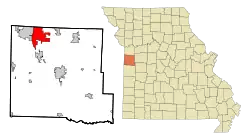 Location in the state of Missouri | |
| Coordinates: 38°48′11″N 94°27′30″W[1] | |
| Country | United States |
| State | Missouri |
| County | Cass |
| Founded | 1874 |
| Incorporated | 1877 |
| Government | |
| • Mayor | Kris Turnbow |
| • City Council | Ward 1 Reginald Townsend Donald Baker Ward 2 Tabitha Forster Joseph Burke III Ward 3 Jay Holman Kevin Barber Ward 4 Sonja Abdelgawad* Tom Engert *mayor pro tempore |
| Area | |
| • Total | 17.65 sq mi (45.72 km2) |
| • Land | 17.31 sq mi (44.84 km2) |
| • Water | 0.34 sq mi (0.88 km2) |
| Elevation | 1,109 ft (338 m) |
| Population (2020) | |
| • Total | 22,941 |
| • Density | 1,325.15/sq mi (511.64/km2) |
| Time zone | UTC-6 (CST) |
| • Summer (DST) | UTC-5 (CDT) |
| ZIP code | 64083 |
| Area code | 816 |
| FIPS code | 29-60752[3] |
| GNIS feature ID | 2396328[1] |
| Website | http://www.raymore.com |
History
Raymore was platted in 1874 and incorporated on March 22, 1877.[4] The name Raymore is an amalgamation of the surnames of two railroad men, Ray and Moore.[5] The Raymore post office has been in operation since 1872.[6]
The Watkins Family Farm Historic District was listed on the National Register of Historic Places in 2007.[7]
Government
The City of Raymore follows a City Council-Manager style of government. The mayor is Kristofer P. Turnbow. On September 9, 2014, Jim Feuerborn was administered his oath of office to serve as Raymore's City Manager (after previously serving as the city's Acting City Manager since June, and the city's Assistant City Manager prior to that). The Raymore City Hall is located at 100 Municipal Circle, just south of Missouri Route 58.
Geography
According to the United States Census Bureau, the city has a total area of 17.75 square miles (45.97 km2), of which 17.58 square miles (45.53 km2) is land and 0.17 square miles (0.44 km2) is water.[8]
Demographics
| Census | Pop. | Note | %± |
|---|---|---|---|
| 1880 | 83 | — | |
| 1900 | 271 | — | |
| 1910 | 218 | −19.6% | |
| 1920 | 182 | −16.5% | |
| 1930 | 222 | 22.0% | |
| 1940 | 207 | −6.8% | |
| 1950 | 208 | 0.5% | |
| 1960 | 268 | 28.8% | |
| 1970 | 587 | 119.0% | |
| 1980 | 3,154 | 437.3% | |
| 1990 | 5,592 | 77.3% | |
| 2000 | 11,146 | 99.3% | |
| 2010 | 19,206 | 72.3% | |
| 2020 | 22,941 | 19.4% | |
| U.S. Decennial Census[9] | |||
2020 census
As of the census[10] of 2020 population estimates, there were 22,941 people and 8,557 households residing in the city. The average population density was 1,325.2 per square mile (2020 Census). The racial makeup of the city was 80.6% White, 10.3% African American, 1.5% Asian, and 0.1% Native American. Hispanic or Latino of any race were 6.1% of the population.
According to the U.S. Census Bureau's latest data for incorporated cities in Missouri, Raymore's estimated population, as of July 1, 2022, is 24,203 residents.
The median income for a household in the city was $90,362, according to the 2023 US Census Quick Facts.
Economy
Largest employers
As of September 2024, the largest employers in the city are:
| # | Employer | # of Employees |
|---|---|---|
| 1 | Walmart | 405 |
| 2 | Ray-Pec School District | 336 |
| 3 | Foxwood Springs | 274 |
| 4 | Compass Health Network | 218 |
| 5 | Cosentino's Price Chopper | 152 |
| 6 | Sam's Club | 150 |
| 7 | Lowe's | 136 |
| 8 | City of Raymore | 108 |
| 9 | Sunrise Nursing & Memory Care | 97 |
| 10 | Benton House of Raymore | 46 |
Education
Public education in Raymore is administered by Raymore-Peculiar R-II School District.[11]
References
- U.S. Geological Survey Geographic Names Information System: Raymore, Missouri
- "ArcGIS REST Services Directory". United States Census Bureau. Retrieved August 28, 2022.
- "U.S. Census website". United States Census Bureau. Retrieved January 31, 2008.
- "Cass County Place Names, 1928–1945 (archived)". The State Historical Society of Missouri. Archived from the original on June 24, 2016. Retrieved September 17, 2016.
{{cite web}}: CS1 maint: bot: original URL status unknown (link) - Eaton, David Wolfe (1916). How Missouri Counties, Towns and Streams Were Named. The State Historical Society of Missouri. pp. 272.
- "Post Offices". Jim Forte Postal History. Retrieved September 17, 2016.
- "National Register Information System". National Register of Historic Places. National Park Service. July 9, 2010.
- "US Gazetteer files 2010". United States Census Bureau. Archived from the original on January 25, 2012. Retrieved July 8, 2012.
- "Census of Population and Housing". Census.gov. Retrieved August 29, 2018.
- United States Census
- "Homepage". Raymore-Peculiar R-Ii School District. Retrieved June 4, 2019.
External links
- City of Raymore
- Stonegate of the Good Ranch HOA
- Silver Lake Homes Association
- Creekmoor, a Cooper Community
Municipalities and communities of Cass County, Missouri, United States | ||
|---|---|---|
| Cities | 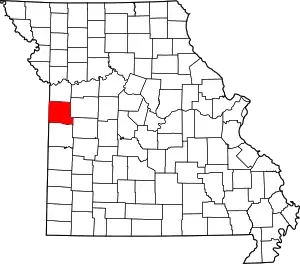 Map of Missouri highlighting Cass County | |
| Villages | ||
| Townships | ||
| Unincorporated communities | ||
| Ghost towns | ||
| Footnotes | ‡This populated place also has portions in an adjacent county or counties | |
Kansas City metropolitan area's cities and counties | ||
|---|---|---|
| Central city | 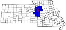 | |
| Largest cities (over 100,000 in 2000) | ||
| Medium-sized cities (10,000 to 100,000 in 2000) | ||
| Smaller cities (between 5,000 and 9,900 in 2010) | ||
| Counties | ||