Randenigala Dam
The Randenigala Dam (Sinhala: රන්දෙනිගල වේල්ල) is a large hydroelectric embankment dam at Rantembe, in the Central Province of Sri Lanka.[1] Construction of the dam began in November 1982, and was completed in approximately 4 years. The dam and power station was ceremonially opened by then President J. R. Jayawardene in 1986.[2]
| Randenigala Dam රන්දෙනිගල වේල්ල | |
|---|---|
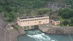
 The Randenigala Dam as seen from the southern bank, with the power station in the background. | |
| Country | Sri Lanka |
| Location | Rantembe, Central Province |
| Coordinates | 07°12′00″N 80°55′30″E |
| Purpose | Power |
| Status | Operational |
| Construction began | November 1982 |
| Opening date | 1986 |
| Construction cost | Rs. 4.898 billion (1986) |
| Owner(s) | Mahaweli Authority |
| Dam and spillways | |
| Type of dam | Embankment dam |
| Impounds | Mahaweli River |
| Height (foundation) | 94 m (308 ft) |
| Length | 485 m (1,591 ft) |
| Elevation at crest | 239 m (784 ft) |
| Width (crest) | 10 m (33 ft) |
| Width (base) | 303 m (994 ft) |
| Spillways | 3 |
| Spillway type | Tainter gate, chute |
| Spillway capacity | 8,100 m3/s (290,000 cu ft/s) |
| Reservoir | |
| Creates | Randenigala Reservoir |
| Total capacity | 861,000,000 m3 (3.04×10¹⁰ cu ft) |
| Active capacity | 558,000,000 m3 (1.97×10¹⁰ cu ft) |
| Catchment area | 2,330 km2 (900 sq mi) |
| Surface area | 1,350 ha (13.5 km2) |
| Operator(s) | CEB |
| Turbines | 2 × 63 MW |
| Installed capacity | 126 MW |
| Annual generation | 428 GWh |
| http://www.mahawelicomplex.lk/randdam.htm | |
Construction of the dam cost approximately Rs. 4.898 billion (1986), of which 24.6% (Rs. 1.207 billion) was funded by the local government, and the majority of the remainder by Germany.[2]
Dam

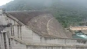
The Randenigala Dam is located 19 km (11.8 mi) downstream of the Victoria Dam, and 2.8 km (1.7 mi) upstream of the Rantembe Dam. Randenigala measures 94 m (308 ft) in height, 485 m (1,591 ft) in length, with a crest and base width of 10 m (33 ft) and 303 m (994 ft) respectively. The embankment dam is made mostly of rocks, and consists of a clay core.[1]
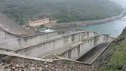
Three large controlled tainter gate chute spillways, with a combined discharge volume of 8,100 m3/s (290,000 cu ft/s), are constructed at the southern end of the dam. The three spillways measure 270 m (886 ft) in length, with a combined width of 48 m (157 ft).[1]
Reservoir

The dam creates the Randenigala Reservoir. With a catchment area of 2,330 km (1,450 mi) and a total storage capacity of 861,000,000 m3 (3.04×10¹⁰ cu ft), Randenigala is one of the largest reservoirs in the country.[1]
The reservoir experiences approximately 1,250–3,000 mm (49.21–118.11 in) of rainfall annually. In addition to this, the reservoir is also topped up with water from the Victoria Reservoir upstream, and the Mahaweli River.[1]
Power station

The power station is located immediately downstream of the dam, on the left bank. Water from the reservoir is delivered to the power station via a single steel-lined tunnel with a length and diameter of 270 m (886 ft) and 6.2 m (20.3 ft) respectively.[1]
The plant consists of two generators with a rated capacity of 63 MW each, powered by two francis turbines. The units were commissioned in August and September 1986 respectively. At a combined capacity of 126 MW, the plant generates 428 GWh annually.[1][2]
References
- "Randenigala Dam and Reservoir". Mahaweli Authority. Retrieved 12 January 2014.
- "Sri Lanka's biggest river basin development project". The Sunday Times. 10 October 2010. Retrieved 12 January 2014.