Maduru Oya Dam
The Maduru Oya Dam is an irrigation dam built across the Maduru Oya. The embankment dam measures 1,090 m (3,580 ft) in length, 41 m (135 ft) in height, and creates the Maduru Oya Reservoir. The reservoir has a catchment area of 453 km2 (175 sq mi) and a storage capacity of 596,000,000 cubic metres (2.10×10¹⁰ cu ft)[1] The proposed Maduru Oya Solar Power Station is to be built over the surface of the Maduru Oya reservoir.[2][3]
| Maduru Oya Dam | |
|---|---|
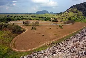 Downstream view of the Maduru Oya Dam | |
| Country | Sri Lanka |
| Location | Eastern Province |
| Coordinates | 07°38′53″N 81°12′50″E |
| Purpose | Irrigation |
| Status | Operational |
| Owner(s) | Mahaweli Authority |
| Dam and spillways | |
| Type of dam | Embankment dam |
| Impounds | Maduru Oya |
| Height (foundation) | 41 m (135 ft) |
| Length | 1,090 m (3,580 ft) |
| Reservoir | |
| Creates | Maduru Oya Reservoir |
| Total capacity | 596,000,000 cubic metres (2.10×10¹⁰ cu ft) |
| Catchment area | 453 km2 (175 sq mi) |
See also
References
- "Maduru Oya Reservoir". Dam Safety and Water Resources Planning Project. Retrieved 1 July 2017.
- "Sri Lanka govt to call bids for 100MW floating solar power plant". Lanka Business Online. 1 March 2017. Retrieved 1 July 2017.
- "100MW floating solar power plant on Maduru Oya". Daily FT. 2 March 2017. Retrieved 1 July 2017.
External links
- Maduru Oya Project: Feasibility Report (PDF). Ministry of Mahaweli Development. 20 August 1980. Retrieved 1 July 2017.
- Maduru Oya Project: Feasibility Report (PDF). USAID. 20 August 1980. Retrieved 1 July 2017.
This article is issued from Wikipedia. The text is licensed under Creative Commons - Attribution - Sharealike. Additional terms may apply for the media files.