Račiněves
Račiněves is a municipality and village in Litoměřice District in the Ústí nad Labem Region of the Czech Republic. It has about 600 inhabitants.
Račiněves | |
|---|---|
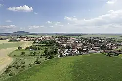
 Aerial view | |
 Flag  Coat of arms | |
 Račiněves Location in the Czech Republic | |
| Coordinates: 50°22′23″N 14°13′7″E | |
| Country | |
| Region | Ústí nad Labem |
| District | Litoměřice |
| First mentioned | 1262 |
| Area | |
| • Total | 11.14 km2 (4.30 sq mi) |
| Elevation | 227 m (745 ft) |
| Population (2023-01-01)[1] | |
| • Total | 634 |
| • Density | 57/km2 (150/sq mi) |
| Time zone | UTC+1 (CET) |
| • Summer (DST) | UTC+2 (CEST) |
| Postal code | 413 01 |
| Website | www |
Račiněves lies approximately 19 kilometres (12 mi) south of Litoměřice, 34 km (21 mi) south of Ústí nad Labem, and 36 km (22 mi) north-west of Prague.
Archaeology
Račiněves is home to an important archaeological site, at which numerous stone tools dating to the Lower Palaeolithic were found.[2]
Gallery
 Northert part
 Church of Saint Gall
 Western part
References
- "Population of Municipalities – 1 January 2023". Czech Statistical Office. 2023-05-23.
- Szymanek, Marcin; Julien, Marie-Anne (2018). "Early and Middle Pleistocene climate-environment conditions in Central Europe and the hominin settlement record". Quaternary Science Reviews. Elsevier BV. 198: 56–75. doi:10.1016/j.quascirev.2018.08.021. ISSN 0277-3791.
Wikimedia Commons has media related to Račiněves.
This article is issued from Wikipedia. The text is licensed under Creative Commons - Attribution - Sharealike. Additional terms may apply for the media files.