Quebec Route 116
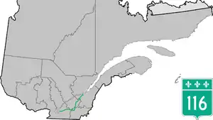
Route 116 is an east/west highway on the south shore of the St. Lawrence River in Quebec, Canada. It runs between Route 134 in Longueuil and Route 132 in Lévis, connecting the south shore areas of Montreal and Quebec City; it also serves the administrative regions of Montérégie, Centre-du-Québec, Estrie and Chaudière-Appalaches. Until the mid-1970s it was known as Route 9 between Le Moyne (presently part of Longueuil) and Saint-Simon; Route 32 between Saint-Simon and Richmond; and Route 5 between Richmond and Saint-Nicolas (presently part of Lévis).[2]
Route 116 | ||||
|---|---|---|---|---|
| Boulevard Sir Wilfrid-Laurier | ||||
 | ||||
| Route information | ||||
| Maintained by Transports Québec | ||||
| Length | 267.3 km[1] (166.1 mi) | |||
| History | ||||
| Major junctions | ||||
| West end | ||||
| East end | ||||
| Location | ||||
| Country | Canada | |||
| Province | Quebec | |||
| Highway system | ||||
| ||||

Route description
Route 116 begins in Longueuil at the junction of Route 134 (Boulevard Taschereau) in Borough of Le Moyne and called Boulevard Sir Wilfrid-Laurier, and name that it holds until Autoroute 20 east of Saint-Hyacinthe. Route 116 shares a concurrency with Route 112 until Saint-Hubert, just south of the Saint-Hubert Municipal Airport, to the junction of Autoroute 30 in Saint-Bruno-de-Montarville. This section is a controlled-access Autoroute-grade freeway. This portion was once envisioned to be part of Autoroute 16. An unofficial extension of Route 116 as thought of by locals, from the western terminus follows the Route 134 limited access expressway to the Jacques Cartier Bridge.
East of Autoroute 30, Route 116 is a high-volume, divided expressway with at-grade intersections as it passes through the growing South Shore suburbs of Montreal. It overlaps with Autoroute 20 for 6 km (4 mi), then has lighter traffic counts up to Richmond. Between Richmond and Plessisville traffic is heavier as it passes bigger towns as it is located further away from Autoroute 20; however the section from Plessisville and Lévis does not have much traffic due to its proximity to Autoroute 20.
Municipalities along Quebec 116
- Longueuil - (Lemoyne / Saint-Hubert)
- Saint-Bruno-de-Montarville
- Saint-Basile-le-Grand
- McMasterville
- Beloeil
- Mont-Saint-Hilaire
- Sainte-Madeleine
- Sainte-Marie-Madeleine
- Saint-Hyacinthe
- Saint-Simon
- Saint-Liboire
- Upton
- Acton Vale
- Sainte-Christine
- Durham-Sud
- Melbourne
- Richmond
- Cleveland
- Danville
- Kingsey Falls
- Warwick
- Saint-Christophe-d'Arthabaska
- Victoriaville
- Princeville
- Plessisville
- Laurierville
- Lyster
- Dosquet
- Saint-Agapit
- Saint-Gilles
- Lévis - (Saint-Étienne-de-Lauzon / Saint-Rédempteur / Saint-Nicolas)
Major intersections
| RCM | Location | km[3] | mi | Exit | Destinations | Notes | ||
|---|---|---|---|---|---|---|---|---|
| Longueuil | Longueuil | 0.0 | 0.0 | 1 | Interchange; R-116 western terminus; west end of R-112 concurrency; west end of freeway | |||
| Boulevard Sir-Wilfrid-Laurier west end | ||||||||
| 1.4– 2.0 | 0.87– 1.2 | 2 | Boulevard Édouard | |||||
| 4.5 | 2.8 | 4 | East end of R-112 concurrency; access to Saint-Hubert Airport | |||||
| Saint-Bruno-de-Montarville | 9.8– 11.3 | 6.1– 7.0 | 8 | Boulevard des Promenades | Eastbound exit uses exit 9 | |||
| 9 | A-30 exit 76; eastbound exit to A-30 west uses exit 8 | |||||||
| 11.3 | 7.0 | Boulevard Seigneurial | At-grade; east end of freeway | |||||
| La Vallée-du-Richelieu | McMasterville–Belœil boundary | 21.8 | 13.5 | West end of R-229 concurrencey | ||||
| Belœil | 24.0 | 14.9 | Partially grade separated | |||||
| Richelieu River | 24.3 | 15.1 | Pont Jordi-Bonet (Jordi-Bonet Bridge) | |||||
| Mont-Saint-Hilaire | 24.6 | 15.3 | Partially grade separated | |||||
| 27.1 | 16.8 | |||||||
| 29.7 | 18.5 | East end of R-229 concurrency | ||||||
| Les Maskoutains | Sainte-Madeleine | 33.7 | 20.9 | |||||
| Saint-Hyacinthe | 43.5 | 27.0 | R-231 northern terminus; west end of R-235 concurrency | |||||
| 45.6 | 28.3 | East end of R-235 concurrency | ||||||
| 46.7 | 29.0 | West end of R-137 concurrency | ||||||
| 47.4 | 29.5 | East end of R-137 concurrency | ||||||
| 50.8 | 31.6 | |||||||
| Saint-Simon | 57.3 | 35.6 | 141 | West end of A-20 concurrency; eastbound access to R-211; exit numbers follow A-20 | ||||
| Boulevard Sir-Wilfrid-Laurier east end | ||||||||
| 58.0 | 36.0 | 143 | ||||||
| Saint-Simon–Saint-Liboire boundary | 60.4 | 37.5 | 145 | Saint-Simon, Saint-Liboire | ||||
| 62.9 | 39.1 | 147 | East end of A-20 concurrency | |||||
| Acton | Acton Vale | 82.3 | 51.1 | West end of R-139 concurrency | ||||
| 83.1 | 51.6 | East end of R-139 concurrency | ||||||
| Drummond |
No major junctions | |||||||
| Le Val-Saint-François | Melbourne | 115.5 | 71.8 | A-55 exit 88 | ||||
| Richmond | 117.0 | 72.7 | West end of R-143 / R-243 concurrency | |||||
| 117.7 | 73.1 | East end of R-243 concurrency | ||||||
| 118.9 | 73.9 | East end of R-143 concurrency | ||||||
| Les Sources | Danville | 135.5 | 84.2 | West end of R-255 concurrency | ||||
| 137.1 | 85.2 | East end of R-255 concurrency | ||||||
| Arthabaska | Warwick | 156.5 | 97.2 | |||||
| Saint-Christophe-d'Arthabaska | 167.0 | 103.8 | West end of R-161 concurrency | |||||
| Victoriaville | 168.8 | 104.9 | Boulevard des Bois-Francs – Centre-Ville | |||||
| 170.5 | 105.9 | Boulevard Jutras | ||||||
| 173.4 | 107.7 | R-122 eastern terminus; east end of R-161 concurrency; to A-955 north | ||||||
| L'Érable | Princeville | 183.5 | 114.0 | |||||
| 185.5 | 115.3 | West end of R-165 concurrency | ||||||
| Plessisville | 193.5 | 120.2 | East end of R-165 concurrency | |||||
| 195.0 | 121.2 | |||||||
| 195.6 | 121.5 | |||||||
| Lyster | 216.7 | 134.7 | West end of R-218 concurrency | |||||
| 218.8 | 136.0 | East end of R-218 concurrency | ||||||
| Lotbinière | Dosquet | 232.8 | 144.7 | |||||
| Saint-Agapit | 246.0 | 152.9 | West end of R-273 concurrency | |||||
| 246.6 | 153.2 | East end of R-165 concurrency | ||||||
| Saint-Gilles | 252.0 | 156.6 | ||||||
| Lévis | 261.0 | 162.2 | West end of R-171 concurrency | |||||
| 261.7 | 162.6 | East end of R-171 concurrency | ||||||
| 271.2 | 168.5 | A-20 exit 311 | ||||||
| 273.8 | 170.1 | R-116 eastern terminus | ||||||
1.000 mi = 1.609 km; 1.000 km = 0.621 mi
| ||||||||
See also
References
- Ministère des transports, "Distances routières", page 59, Les Publications du Québec, 2005
- The H.M. Gousha Company (1955). Shell Map of Quebec and Maritime Provinces (Map). The Shell Oil Company. §§ D-9, E-8, E-9, F-8, G-5, G-6, G-7, G-8.
- Google (April 13, 2023). "Route 116 in Quebec" (Map). Google Maps. Google. Retrieved April 13, 2023.
External links
- Interactive Provincial Route Map (Transports Québec) (in French)
- Highway 116 at motorways-exits.com
- Route 116 on Google Maps