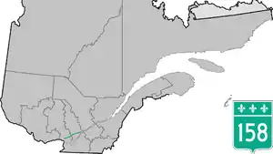
Quebec Route 158
Route 158 is an east-west arterial road running between Lachute and Berthierville, north of the Ottawa and Saint Lawrence rivers, in the Laurentides region.
Route 158 | ||||
|---|---|---|---|---|
 | ||||
| Route information | ||||
| Maintained by Transports Québec | ||||
| Length | 124.3 km[1][2] (77.2 mi) | |||
| History | ||||
| Major junctions | ||||
| West end | ||||
| East end | ||||
| Location | ||||
| Country | Canada | |||
| Province | Quebec | |||
| Major cities | Lachute, Saint-Jérôme, Joliette | |||
| Highway system | ||||
| ||||

It runs parallel to Autoroute 50 from Lachute to Autoroute 15 near Mirabel Airport, also passing through Joliette. A section of the 158 in Joliette is a four-lane short freeway and was intended to be part of an eastern extension of A-50 towards A-40 in Berthierville by-passing several accident-prone sections of Highway 158.
In Berthierville, it junctions with Autoroute 40 and Route 138 and ends on the island municipality of Saint-Ignace-de-Loyola at the Saint Lawrence River, which can be crossed by car ferry to Route 132 in Sorel-Tracy.
Municipalities along Route 158
- Lachute
- Mirabel
- Saint-Jérôme
- Sainte-Sophie
- Saint-Lin-Laurentides
- Saint-Esprit
- Saint-Alexis
- Saint-Jacques
- Crabtree
- Saint-Paul
- Joliette
- Saint-Thomas
- Sainte-Geneviève-de-Berthier
- Berthierville
- La Visitation-de-l'Île-Dupas
- Saint-Ignace-de-Loyola
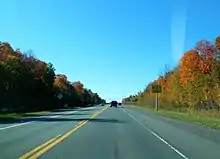
Quebec Route 158 in October 2014
Major intersections
| RCM | Location | km[2] | mi | Destinations | Notes |
|---|---|---|---|---|---|
| Argenteuil | Lachute | 0.0 | 0.0 | R-158 western terminus; west end of R-148 concurrency | |
| 2.1 | 1.3 | West end of R-329 concurrency | |||
| 3.0 | 1.9 | East end of R-329 concurrency | |||
| Mirabel | 11.9 | 7.4 | East end of R-148 concurrency | ||
| 29.6 | 18.4 | Interchange; A-15 exit 39 | |||
| La Rivière-du-Nord | Saint-Jérôme | 31.7 | 19.7 | ||
| Montcalm | Saint-Lin–Laurentides | 53.8 | 33.4 | West end of R-335 / R-337 concurrency; R-339 northern terminus | |
| 55.5 | 34.5 | East end of R-335 / R-337 concurrency | |||
| Saint-Esprit | 62.9 | 39.1 | Rang de la Côte-Saint-Louis / Ancienne Route 125 | Roundabout; former R-125 south | |
| 63.6 | 39.5 | Interchange; A-25 exit 46; west end of A-25 / R-125 concurrency; A-25 north is unsigned north of R-158; R-125 is unsigned south of R-158 | |||
| 65.7 | 40.8 | A-25 northern terminus; east end of A-25 / R-125 concurrency | |||
| Saint-Jacques | 74.4 | 46.2 | Roundabout | ||
| Joliette | Saint-Paul | 86.5 | 53.7 | ||
| Joliette | 89.5 | 55.6 | Boulevard de la Base-de-Roc | Interchange | |
| 90.4 | 56.2 | Interchange; A-31 exit 14; A-31 northern terminus; west end of R-131 concurrency | |||
| 91.1 | 56.6 | East end of R-131 concurrency | |||
| D'Autray | Sainte-Geneviève-de-Berthier | 111.7 | 69.4 | Roundabout | |
| 114.1 | 70.9 | ||||
| Berthierville | 116.6 | 72.5 | Interchange; A-40 exit 144 | ||
| 117.8 | 73.2 | West end of R-138 concurrency | |||
| 118.8 | 73.8 | East end of R-138 concurrency | |||
| Saint-Ignace-de-Loyola | 124.3 | 77.2 | R-158 eastern terminus | ||
| St. Lawrence River | |||||
1.000 mi = 1.609 km; 1.000 km = 0.621 mi
| |||||
See also
References
- Ministère des transports, "Distances routières", page 72, Les Publications du Québec, 2005
- Google (May 12, 2023). "Quebec Route 158" (Map). Google Maps. Google. Retrieved May 12, 2023.
- The H.M. Gousha Company (1955). "Québec" (Map). Shell Map of Quebec and Maritime Provinces. The Shell Oil Company. §§ F-5, G-5, F-6.
This article is issued from Wikipedia. The text is licensed under Creative Commons - Attribution - Sharealike. Additional terms may apply for the media files.