Portal:Geophysics
The Geophysics Portal
Geophysics (/ˌdʒiːoʊˈfɪzɪks/) is a subject of natural science concerned with the physical processes and physical properties of the Earth and its surrounding space environment, and the use of quantitative methods for their analysis. Geophysicists, who usually study geophysics, physics, or one of the earth sciences at the graduate level, complete investigations across a wide range of scientific disciplines. The term geophysics classically refers to solid earth applications: Earth's shape; its gravitational, magnetic fields, and electromagnetic fields ; its internal structure and composition; its dynamics and their surface expression in plate tectonics, the generation of magmas, volcanism and rock formation. However, modern geophysics organizations and pure scientists use a broader definition that includes the water cycle including snow and ice; fluid dynamics of the oceans and the atmosphere; electricity and magnetism in the ionosphere and magnetosphere and solar-terrestrial physics; and analogous problems associated with the Moon and other planets.
Although geophysics was only recognized as a separate discipline in the 19th century, its origins date back to ancient times. The first magnetic compasses were made from lodestones, while more modern magnetic compasses played an important role in the history of navigation. The first seismic instrument was built in 132 AD. Isaac Newton applied his theory of mechanics to the tides and the precession of the equinox; and instruments were developed to measure the Earth's shape, density and gravity field, as well as the components of the water cycle. In the 20th century, geophysical methods were developed for remote exploration of the solid Earth and the ocean, and geophysics played an essential role in the development of the theory of plate tectonics. (Full article...)
Selected general articles

_-_Google_Art_Project.jpg.webp) Radiocarbon dating helped verify the authenticity of the Dead Sea scrolls.
Radiocarbon dating helped verify the authenticity of the Dead Sea scrolls.
Radiocarbon dating (also referred to as carbon dating or carbon-14 dating) is a method for determining the age of an object containing organic material by using the properties of radiocarbon, a radioactive isotope of carbon.
The method was developed in the late 1940s at the University of Chicago by Willard Libby. It is based on the fact that radiocarbon (14
C) is constantly being created in the Earth's atmosphere by the interaction of cosmic rays with atmospheric nitrogen. The resulting 14
C combines with atmospheric oxygen to form radioactive carbon dioxide, which is incorporated into plants by photosynthesis; animals then acquire 14
C by eating the plants. When the animal or plant dies, it stops exchanging carbon with its environment, and thereafter the amount of 14
C it contains begins to decrease as the 14
C undergoes radioactive decay. Measuring the proportion of 14
C in a sample from a dead plant or animal, such as a piece of wood or a fragment of bone, provides information that can be used to calculate when the animal or plant died. The older a sample is, the less 14
C there is to be detected, and because the half-life of 14
C (the period of time after which half of a given sample will have decayed) is about 5,730 years, the oldest dates that can be reliably measured by this process date to approximately 50,000 years ago (in this interval about 99.8% of the 14
C will have decayed), although special preparation methods occasionally make an accurate analysis of older samples possible. In 1960, Libby received the Nobel Prize in Chemistry for his work. (Full article...) Schiehallion's isolated position and symmetrical shape were well-suited to the experiment
The Schiehallion experiment was an 18th-century experiment to determine the mean density of the Earth. Funded by a grant from the Royal Society, it was conducted in the summer of 1774 around the Scottish mountain of Schiehallion, Perthshire. The experiment involved measuring the tiny deflection of the vertical due to the gravitational attraction of a nearby mountain. Schiehallion was considered the ideal location after a search for candidate mountains, thanks to its isolation and almost symmetrical shape.
The experiment had previously been considered, but rejected, by Isaac Newton as a practical demonstration of his theory of gravitation; however, a team of scientists, notably Nevil Maskelyne, the Astronomer Royal, was convinced that the effect would be detectable and undertook to conduct the experiment. The deflection angle depended on the relative densities and volumes of the Earth and the mountain: if the density and volume of Schiehallion could be ascertained, then so could the density of the Earth. Once this was known, it would in turn yield approximate values for those of the other planets, their moons, and the Sun, previously known only in terms of their relative ratios. (Full article...)
The Compton–Belkovich Thorium Anomaly is a volcanic complex on the far side of the Moon. It was found by a gamma-ray spectrometer in 1998 and is an area of concentrated thorium, a 'fertile' element. Lunar rock samples from the Apollo missions reveal that most lunar volcanism occurred around 3 to 4 billion years ago, but this feature could have formed as recently as 1 billion years ago due to the unknown history of the Moon's far side. (Full article...)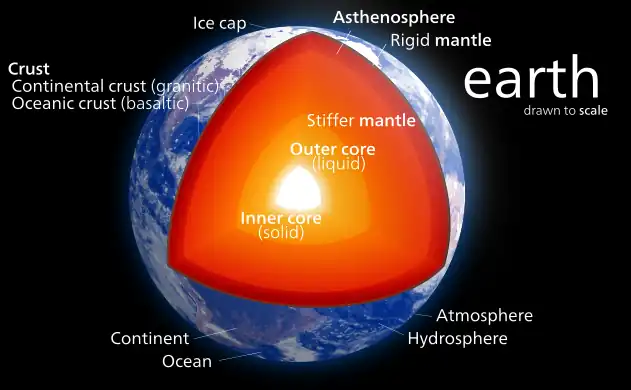 The internal structure of Earth
Earth's inner core is the innermost geologic layer of planet Earth. It is primarily a solid ball with a radius of about 1,220 km (760 mi), which is about 20% of Earth's radius or 70% of the Moon's radius.
There are no samples of Earth's core accessible for direct measurement, as there are for Earth's mantle. Information about Earth's core mostly comes from analysis of seismic waves and Earth's magnetic field. The inner core is believed to be composed of an iron–nickel alloy with some other elements. The temperature at the inner core's surface is estimated to be approximately 5,700 K (5,430 °C; 9,800 °F), which is about the temperature at the surface of the Sun. (Full article...)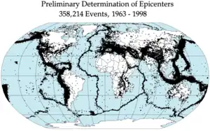 Earthquake epicenters occur mostly along tectonic plate boundaries, especially on the Pacific Ring of Fire.
An earthquake (also known as a quake, tremor or temblor) is the shaking of the surface of the Earth resulting from a sudden release of energy in the Earth's lithosphere that creates seismic waves. Earthquakes can range in intensity, from those that are so weak that they cannot be felt, to those violent enough to propel objects and people into the air, damage critical infrastructure, and wreak destruction across entire cities. The seismic activity of an area is the frequency, type, and size of earthquakes experienced over a particular time. The seismicity at a particular location in the Earth is the average rate of seismic energy release per unit volume. The word tremor is also used for non-earthquake seismic rumbling.
At the Earth's surface, earthquakes manifest themselves by shaking and displacing or disrupting the ground. When the epicenter of a large earthquake is located offshore, the seabed may be displaced sufficiently to cause a tsunami. Earthquakes can also trigger landslides. (Full article...)- The Chandler wobble or Chandler variation of latitude is a small deviation in the Earth's axis of rotation relative to the solid earth, which was discovered by and named after American astronomer Seth Carlo Chandler in 1891. It amounts to change of about 9 metres (30 ft) in the point at which the axis intersects the Earth's surface and has a period of 433 days. This wobble, which is an astronomical nutation, combines with another wobble with a period of one year, so that the total polar motion varies with a period of about 7 years.
The Chandler wobble is an example of the kind of motion that can occur for a freely rotating object that is not a sphere; this is called a free nutation. Somewhat confusingly, the direction of the Earth's rotation axis relative to the stars also varies with different periods, and these motions—caused by the tidal forces of the Moon and Sun—are also called nutations, except for the slowest, which are precessions of the equinoxes. (Full article...)
Tidal acceleration is an effect of the tidal forces between an orbiting natural satellite (e.g. the Moon) and the primary planet that it orbits (e.g. Earth). The acceleration causes a gradual recession of a satellite in a prograde orbit away from the primary, and a corresponding slowdown of the primary's rotation. The process eventually leads to tidal locking, usually of the smaller body first, and later the larger body (e.g. theoretically with Earth in 50 billion years). The Earth–Moon system is the best-studied case.
The similar process of tidal deceleration occurs for satellites that have an orbital period that is shorter than the primary's rotational period, or that orbit in a retrograde direction. (Full article...)
Atmospheric electricity describes the electrical charges in the Earth's atmosphere (or that of another planet). The movement of charge between the Earth's surface, the atmosphere, and the ionosphere is known as the global atmospheric electrical circuit. Atmospheric electricity is an interdisciplinary topic with a long history, involving concepts from electrostatics, atmospheric physics, meteorology and Earth science.
Thunderstorms act as a giant battery in the atmosphere, charging up the electrosphere to about 400,000 volts with respect to the surface. This sets up an electric field throughout the atmosphere, which decreases with increase in altitude. Atmospheric ions created by cosmic rays and natural radioactivity move in the electric field, so a very small current flows through the atmosphere, even away from thunderstorms. Near the surface of the Earth, the magnitude of the field is on average around 100 V/m, oriented such that it drives positive charges down. (Full article...)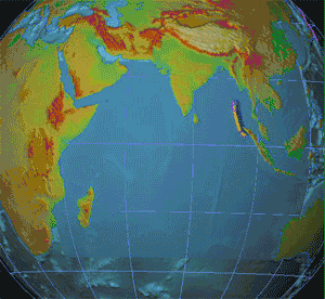 Animation of tsunami triggered by the 2004 Indian Ocean earthquake
Seismology (/saɪzˈmɒlədʒi, saɪs-/; from Ancient Greek σεισμός (seismós) meaning "earthquake" and -λογία (-logía) meaning "study of") is the scientific study of earthquakes (or generally, quakes) and the propagation of elastic waves through the Earth or other planetary bodies. It also includes studies of earthquake environmental effects such as tsunamis as well as diverse seismic sources such as volcanic, tectonic, glacial, fluvial, oceanic, atmospheric, and artificial processes such as explosions. A related field that uses geology to infer information regarding past earthquakes is paleoseismology. A recording of Earth motion as a function of time is called a seismogram. A seismologist is a scientist who does research in seismology. (Full article...)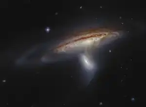 Tidal interaction between the barred spiral galaxy NGC 169 and a smaller companion
The tidal force or tide-generating force is a gravitational effect that stretches a body along the line towards and away from the center of mass of another body due to spatial variations in strength in gravitational field from the other body. It is responsible for the tides and related phenomena, including solid-earth tides, tidal locking, breaking apart of celestial bodies and formation of ring systems within the Roche limit, and in extreme cases, spaghettification of objects. It arises because the gravitational field exerted on one body by another is not constant across its parts: the nearer side is attracted more strongly than the farther side. The difference is positive in the near side and negative in the far side, which causes a body to get stretched. Thus, the tidal force is also known as the differential force, residual force, or secondary effect of the gravitational field.
In celestial mechanics, the expression tidal force can refer to a situation in which a body or material (for example, tidal water) is mainly under the gravitational influence of a second body (for example, the Earth), but is also perturbed by the gravitational effects of a third body (for example, the Moon). The perturbing force is sometimes in such cases called a tidal force (for example, the perturbing force on the Moon): it is the difference between the force exerted by the third body on the second and the force exerted by the third body on the first. (Full article...)- Geophysical survey is the systematic collection of geophysical data for spatial studies. Detection and analysis of the geophysical signals forms the core of Geophysical signal processing. The magnetic and gravitational fields emanating from the Earth's interior hold essential information concerning seismic activities and the internal structure. Hence, detection and analysis of the electric and Magnetic fields is very crucial. As the Electromagnetic and gravitational waves are multi-dimensional signals, all the 1-D transformation techniques can be extended for the analysis of these signals as well. Hence this article also discusses multi-dimensional signal processing techniques.
Geophysical surveys may use a great variety of sensing instruments, and data may be collected from above or below the Earth's surface or from aerial, orbital, or marine platforms. Geophysical surveys have many applications in geology, archaeology, mineral and energy exploration, oceanography, and engineering. Geophysical surveys are used in industry as well as for academic research. (Full article...) 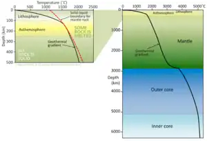 Temperature profile of inner Earth, schematic view (estimated). The red dashed line shows the minimum temperature for the respective mantle rock to melt. The geothermal gradient remains below the melting temperature of the rock, except in the asthenosphere. Sharp rises occur in the uppermost mantle and at the core–mantle boundary.
Geothermal gradient is the rate of change in temperature with respect to increasing depth in Earth's interior. As a general rule, the crust temperature rises with depth due to the heat flow from the much hotter mantle; away from tectonic plate boundaries, temperature rises in about 25–30 °C/km (72–87 °F/mi) of depth near the surface in most of the world. However, in some cases the temperature may drop with increasing depth, especially near the surface, a phenomenon known as inverse or negative geothermal gradient. The effects of weather, the Sun, and season only reach a depth of roughly 10–20 m (33–66 ft).
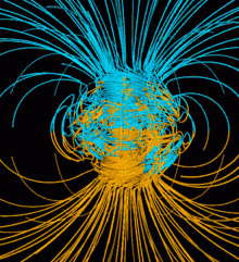
Strictly speaking, geo-thermal necessarily refers to Earth, but the concept may be applied to other planets. In SI units, the geothermal gradient is expressed as °C/km, K/km, or mK/m. These are all equivalent. (Full article...) Illustration of the dynamo mechanism that generates the Earth's magnetic field: convection currents of fluid metal in the Earth's outer core, driven by heat flow from the inner core, organized into rolls by the Coriolis force, generate circulating electric currents, which supports the magnetic field.
In physics, the dynamo theory proposes a mechanism by which a celestial body such as Earth or a star generates a magnetic field. The dynamo theory describes the process through which a rotating, convecting, and electrically conducting fluid can maintain a magnetic field over astronomical time scales. A dynamo is thought to be the source of the Earth's magnetic field and the magnetic fields of Mercury and the Jovian planets. (Full article...)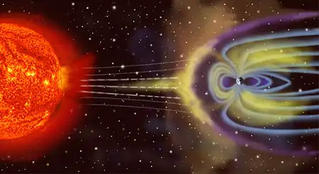 Artist's depiction of solar wind particles interacting with Earth's magnetosphere. Sizes are not to scale.
A geomagnetic storm, also known as a magnetic storm, is a temporary disturbance of the Earth's magnetosphere caused by a solar wind shock wave and/or cloud of magnetic field that interacts with the Earth's magnetic field.
The disturbance that drives the magnetic storm may be a solar coronal mass ejection (CME) or (much less severely) a co-rotating interaction region (CIR), a high-speed stream of solar wind originating from a coronal hole. The frequency of geomagnetic storms increases and decreases with the sunspot cycle. During solar maximum, geomagnetic storms occur more often, with the majority driven by CMEs. (Full article...)_near_Swiss_Camp_(Greenland)_1.jpg.webp) Automatic ground penetrating Radar (upGPR) near Swiss Camp (Greenland)
Automatic ground penetrating Radar (upGPR) near Swiss Camp (Greenland)
Near-surface geophysics is the use of geophysical methods to investigate small-scale features in the shallow (tens of meters) subsurface. It is closely related to applied geophysics or exploration geophysics. Methods used include seismic refraction and reflection, gravity, magnetic, electric, and electromagnetic methods. Many of these methods were developed for oil and mineral exploration but are now used for a great variety of applications, including archaeology, environmental science, forensic science, military intelligence, geotechnical investigation, treasure hunting, and hydrogeology. In addition to the practical applications, near-surface geophysics includes the study of biogeochemical cycles. (Full article...)
A series of small volcanic earthquakes measuring less than 4.0 on the Richter magnitude scale took place in the sparsely populated Nazko area of the Central Interior of British Columbia, Canada, from October 9, 2007, to June 12, 2008. They occurred just west of Nazko Cone, a small tree-covered cinder cone that last erupted about 7,200 years ago.
No damage or casualties resulted from the Nazko earthquakes, which were too small to be felt by people, but local seismographs recorded them. The earthquake swarm occurred at the eastern end of a known volcanic zone called the Anahim Volcanic Belt. This is an east–west trending line of volcanic formations extending from the Central Coast to the Central Interior of British Columbia. (Full article...)- In astronomy and planetary science, a magnetosphere is a region of space surrounding an astronomical object in which charged particles are affected by that object's magnetic field. It is created by a celestial body with an active interior dynamo.
In the space environment close to a planetary body, the magnetic field resembles a magnetic dipole. Farther out, field lines can be significantly distorted by the flow of electrically conducting plasma, as emitted from the Sun (i.e., the solar wind) or a nearby star. Planets having active magnetospheres, like the Earth, are capable of mitigating or blocking the effects of solar radiation or cosmic radiation, that also protects all living organisms from potentially detrimental and dangerous consequences. This is studied under the specialized scientific subjects of plasma physics, space physics, and aeronomy. (Full article...) 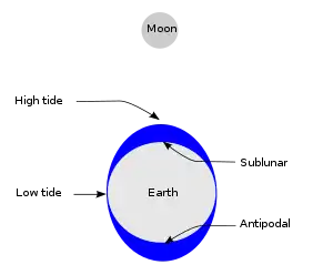 Simplified schematic of only the lunar portion of Earth's tides, showing (exaggerated) high tides at the sublunar point and its antipode for the hypothetical case of an ocean of constant depth without land, and on the assumption that Earth is not rotating; otherwise there is a lag angle. Solar tides not shown.
Tides are the rise and fall of sea levels caused by the combined effects of the gravitational forces exerted by the Moon (and to a much lesser extent, the Sun) and are also caused by the Earth and Moon orbiting one another.
Tide tables can be used for any given locale to find the predicted times and amplitude (or "tidal range").
The predictions are influenced by many factors including the alignment of the Sun and Moon, the phase and amplitude of the tide (pattern of tides in the deep ocean), the amphidromic systems of the oceans, and the shape of the coastline and near-shore bathymetry (see Timing). They are however only predictions, the actual time and height of the tide is affected by wind and atmospheric pressure. Many shorelines experience semi-diurnal tides—two nearly equal high and low tides each day. Other locations have a diurnal tide—one high and low tide each day. A "mixed tide"—two uneven magnitude tides a day—is a third regular category. (Full article...)- Geodynamics is a subfield of geophysics dealing with dynamics of the Earth. It applies physics, chemistry and mathematics to the understanding of how mantle convection leads to plate tectonics and geologic phenomena such as seafloor spreading, mountain building, volcanoes, earthquakes, faulting. It also attempts to probe the internal activity by measuring magnetic fields, gravity, and seismic waves, as well as the mineralogy of rocks and their isotopic composition. Methods of geodynamics are also applied to exploration of other planets. (Full article...)
- In geodesy, the figure of the Earth is the size and shape used to model planet Earth. The kind of figure depends on application, including the precision needed for the model. A spherical Earth is a well-known historical approximation that is satisfactory for geography, astronomy and many other purposes. Several models with greater accuracy (including ellipsoid) have been developed so that coordinate systems can serve the precise needs of navigation, surveying, cadastre, land use, and various other concerns. (Full article...)
- Radiometric dating, radioactive dating or radioisotope dating is a technique which is used to date materials such as rocks or carbon, in which trace radioactive impurities were selectively incorporated when they were formed. The method compares the abundance of a naturally occurring radioactive isotope within the material to the abundance of its decay products, which form at a known constant rate of decay. The use of radiometric dating was first published in 1907 by Bertram Boltwood and is now the principal source of information about the absolute age of rocks and other geological features, including the age of fossilized life forms or the age of Earth itself, and can also be used to date a wide range of natural and man-made materials.
Together with stratigraphic principles, radiometric dating methods are used in geochronology to establish the geologic time scale. Among the best-known techniques are radiocarbon dating, potassium–argon dating and uranium–lead dating. By allowing the establishment of geological timescales, it provides a significant source of information about the ages of fossils and the deduced rates of evolutionary change. Radiometric dating is also used to date archaeological materials, including ancient artifacts. (Full article...) 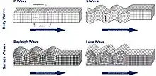 Body waves and surface waves
A seismic wave is a mechanical wave of acoustic energy that travels through the Earth or another planetary body. It can result from an earthquake (or generally, a quake), volcanic eruption, magma movement, a large landslide, and a large man-made explosion that produces low-frequency acoustic energy. Seismic waves are studied by seismologists, who record the waves using seismometers, hydrophones (in water), or accelerometers. Seismic waves are distinguished from seismic noise (ambient vibration), which is persistent low-amplitude vibration arising from a variety of natural and anthropogenic sources.
The propagation velocity of a seismic wave depends on density and elasticity of the medium as well as the type of wave. Velocity tends to increase with depth through Earth's crust and mantle, but drops sharply going from the mantle to Earth's outer core. (Full article...)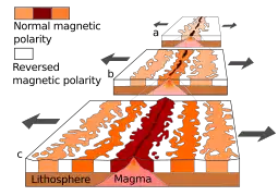 Magnetic stripes are the result of reversals of the Earth's field and seafloor spreading. New oceanic crust is magnetized as it forms and then it moves away from the ridge in both directions. The models show a ridge (a) about 5 million years ago (b) about 2 million years ago and (c) in the present.
Paleomagnetism (occasionally palaeomagnetism) is the study of magnetic fields recorded in rocks, sediment, or archeological materials. Geophysicists who specialize in paleomagnetism are called paleomagnetists.
Certain magnetic minerals in rocks can record the direction and intensity of Earth's magnetic field at the time they formed. This record provides information on the past behavior of the geomagnetic field and the past location of tectonic plates. The record of geomagnetic reversals preserved in volcanic and sedimentary rock sequences (magnetostratigraphy) provides a time-scale that is used as a geochronologic tool. (Full article...)
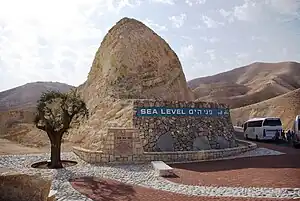
Mean sea level (MSL, often shortened to sea level) is an average surface level of one or more among Earth's coastal bodies of water from which heights such as elevation may be measured. The global MSL is a type of vertical datum – a standardised geodetic datum – that is used, for example, as a chart datum in cartography and marine navigation, or, in aviation, as the standard sea level at which atmospheric pressure is measured to calibrate altitude and, consequently, aircraft flight levels. A common and relatively straightforward mean sea-level standard is instead the midpoint between a mean low and mean high tide at a particular location.
Sea levels can be affected by many factors and are known to have varied greatly over geological time scales. Current sea level rise is mainly caused by human-induced climate change. When temperatures rise, mountain glaciers and the polar ice caps melt, increasing the amount of water in water bodies. Because most of human settlement and infrastructure was built in response to a more normalized sea level with limited expected change, populations affected by climate change in connection to sea level rise will need to invest in climate adaptation to mitigate the worst effects or when populations are in extreme risk, a process of managed retreat. (Full article...)- The Hollow Moon and the closely related Spaceship Moon are pseudoscientific hypotheses that propose that Earth's Moon is either wholly hollow or otherwise contains a substantial interior space. No scientific evidence exists to support the idea; seismic observations and other data collected since spacecraft began to orbit or land on the Moon indicate that it has a thin crust, extensive mantle and small, dense core, although overall it is much less dense than Earth.
The first publication to mention a hollow Moon was H. G. Wells' 1901 novel The First Men in the Moon. The concept of a (partially) hollow Moon has been employed in science fiction multiple times. In 1970, two Soviet authors published a short piece in the popular press speculating that the Moon might be "the Creation of Alien Intelligence". Since the late 1970s, the hypothesis has been endorsed by conspiracy theorists like Jim Marrs and David Icke. (Full article...)


Selected geophysicist
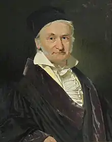
Johann Carl Friedrich Gauss (German: Gauß [kaʁl ˈfʁiːdʁɪç ˈɡaʊs] ⓘ; Latin: Carolus Fridericus Gauss; 30 April 1777 – 23 February 1855) was a German mathematician, geodesist, and physicist who made significant contributions to many fields in mathematics and science. Gauss ranks among history's most influential mathematicians. He is referred to as the "Prince of Mathematicians".
Gauss was a child prodigy in mathematics, and while still a student at the University of Göttingen he propounded several mathematical theorems. Gauss completed his masterpieces Disquisitiones Arithmeticae and Theoria motus corporum coelestium as a private scholar. Later he was director of the Göttingen Observatory and professor at the university for nearly half a century, from 1807 until his death in 1855. (Full article...)
Shen Kuo (Chinese: 沈括; 1031–1095) or Shen Gua, courtesy name Cunzhong (存中) and pseudonym Mengqi (now usually given as Mengxi) Weng (夢溪翁), was a Chinese polymath, scientist, and statesman of the Song dynasty (960–1279). Shen was a master in many fields of study including mathematics, optics, and horology. In his career as a civil servant, he became a finance minister, governmental state inspector, head official for the Bureau of Astronomy in the Song court, Assistant Minister of Imperial Hospitality, and also served as an academic chancellor. At court his political allegiance was to the Reformist faction known as the New Policies Group, headed by Chancellor Wang Anshi (1021–1085).
In his Dream Pool Essays or Dream Torrent Essays (夢溪筆談; Mengxi Bitan) of 1088, Shen was the first to describe the magnetic needle compass, which would be used for navigation (first described in Europe by Alexander Neckam in 1187). Shen discovered the concept of true north in terms of magnetic declination towards the north pole, with experimentation of suspended magnetic needles and "the improved meridian determined by Shen's [astronomical] measurement of the distance between the pole star and true north". This was the decisive step in human history to make compasses more useful for navigation, and may have been a concept unknown in Europe for another four hundred years (evidence of German sundials made circa 1450 show markings similar to Chinese geomancers' compasses in regard to declination). (Full article...)
Kristian Olaf Bernhard Birkeland (born 13 December 1867 in Christiania (today's Oslo) – 15 June 1917 in Tokyo, Japan) was a Norwegian scientist, professor of physics at the Royal Fredriks University in Oslo. He is best remembered for his theories of atmospheric electric currents that elucidated the nature of the aurora borealis. In order to fund his research on the aurorae, he invented the electromagnetic cannon and the Birkeland–Eyde process of fixing nitrogen from the air. Birkeland was nominated for the Nobel Prize seven times. (Full article...)
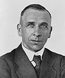
Alfred Lothar Wegener (/ˈveɪɡənər/; German: [ˈʔalfʁeːt ˈveːɡənɐ]; 1 November 1880 – November 1930) was a German climatologist, geologist, geophysicist, meteorologist, and polar researcher.
During his lifetime he was primarily known for his achievements in meteorology and as a pioneer of polar research, but today he is most remembered as the originator of continental drift hypothesis by suggesting in 1912 that the continents are slowly drifting around the Earth (German: Kontinentalverschiebung). His hypothesis was controversial and widely rejected by mainstream geology until the 1950s, when numerous discoveries such as palaeomagnetism provided strong support for continental drift, and thereby a substantial basis for today's model of plate tectonics. Wegener was involved in several expeditions to Greenland to study polar air circulation before the existence of the jet stream was accepted. Expedition participants made many meteorological observations and were the first to overwinter on the inland Greenland ice sheet and the first to bore ice cores on a moving Arctic glacier. (Full article...)
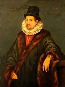
William Gilbert (/ˈɡɪlbərt/; 24 May 1544? – 30 November 1603), also known as Gilberd, was an English physician, physicist and natural philosopher. He passionately rejected both the prevailing Aristotelian philosophy and the Scholastic method of university teaching. He is remembered today largely for his book De Magnete (1600).
A unit of magnetomotive force, also known as magnetic potential, was named the Gilbert in his honour. (Full article...)
Albert Francis Birch (August 22, 1903 – January 30, 1992) was an American geophysicist. He is considered one of the founders of solid Earth geophysics. He is also known for his part in the atomic bombing of Hiroshima and Nagasaki.
During World War II, Birch participated in the Manhattan Project, working on the design and development of the gun-type nuclear weapon known as Little Boy. He oversaw its manufacture, and went to Tinian to supervise its assembly and loading into Enola Gay, the Boeing B-29 Superfortress tasked with dropping the bomb. (Full article...)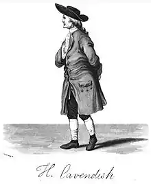
Henry Cavendish FRS (/ˈkævəndɪʃ/ KAV-ən-dish; 10 October 1731 – 24 February 1810) was an English natural philosopher and scientist who was an important experimental and theoretical chemist and physicist. He is noted for his discovery of hydrogen, which he termed "inflammable air". He described the density of inflammable air, which formed water on combustion, in a 1766 paper, On Factitious Airs. Antoine Lavoisier later reproduced Cavendish's experiment and gave the element its name.
A shy man, Cavendish was distinguished for great accuracy and precision in his researches into the composition of atmospheric air, the properties of different gases, the synthesis of water, the law governing electrical attraction and repulsion, a mechanical theory of heat, and calculations of the density (and hence the mass) of the Earth. His experiment to measure the density of the Earth (which, in turn, allows the gravitational constant to be calculated) has come to be known as the Cavendish experiment. (Full article...)
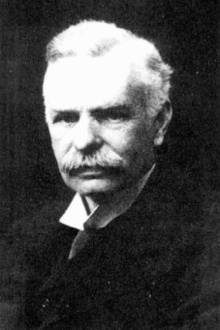
Andrija Mohorovičić (23 January 1857 – 18 December 1936) was a Croatian geophysicist. He is best known for the eponymous Mohorovičić discontinuity and is considered one of the founders of modern seismology. (Full article...)
Charles Francis Richter (/ˈrɪktər/; April 26, 1900 – September 30, 1985) was an American seismologist and physicist.
Richter is most famous as the creator of the Richter magnitude scale, which, until the development of the moment magnitude scale in 1979, quantified the size of earthquakes. Inspired by Kiyoo Wadati's 1928 paper on shallow and deep earthquakes, Richter first used the scale in 1935 after developing it in collaboration with Beno Gutenberg; both worked at the California Institute of Technology. (Full article...)
Eugene Newman Parker (June 10, 1927 – March 15, 2022) was an American solar and plasma physicist. In the 1950s he proposed the existence of the solar wind and that the magnetic field in the outer Solar System would be in the shape of a Parker spiral, predictions that were later confirmed by spacecraft measurements. In 1987, Parker proposed the existence of nanoflares, a leading candidate to explain the coronal heating problem.
Parker obtained his PhD from Caltech and spent four years as a postdoctoral researcher at the University of Utah. He joined University of Chicago in 1955 and spent the rest of his career there, holding positions in the physics department, the astronomy and astrophysics department, and the Enrico Fermi Institute. Parker was elected to the National Academy of Sciences in 1967. In 2017, NASA named its Parker Solar Probe in his honor, the first NASA spacecraft named after a living person. (Full article...)
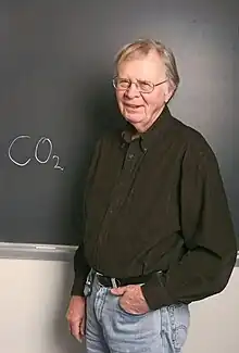
Wallace "Wally" Smith Broecker (November 29, 1931 – February 18, 2019) was an American geochemist. He was the Newberry Professor in the Department of Earth and Environmental Sciences at Columbia University, a scientist at Columbia's Lamont–Doherty Earth Observatory and a sustainability fellow at Arizona State University. He developed the idea of a global "conveyor belt" linking the circulation of the global ocean and made major contributions to the science of the carbon cycle and the use of chemical tracers and isotope dating in oceanography. Broecker popularized the term "global warming". He received the Crafoord Prize and the Vetlesen Prize. (Full article...)- Richard Doell (1923 – March 6, 2008) was a distinguished American scientist known for developing the time scale for geomagnetic reversals with Allan V. Cox and Brent Dalrymple. This work was a major step in the development of plate tectonics. Doell shared the Vetlesen Prize with Cox and Dalrymple. (Full article...)
.jpg.webp)
Adam Marian Dziewoński (November 15, 1936 – March 1, 2016) was a Polish-American geophysicist who made seminal contributions to the determination of the large-scale structure of the Earth's interior and the nature of earthquakes using seismological methods. He spent most of his career at Harvard University, where he was the Frank B. Baird, Jr. Professor of Science. (Full article...)
Richard Dixon Oldham FRS (/ˈoʊldəm/; 31 July 1858 – 15 July 1936) was a British geologist who made the first clear identification of the separate arrivals of P-waves, S-waves and surface waves on seismograms and the first clear evidence that the Earth has a central core. (Full article...)
Friedrich Wilhelm Heinrich Alexander von Humboldt (14 September 1769 – 6 May 1859) was a German polymath, geographer, naturalist, explorer, and proponent of Romantic philosophy and science. He was the younger brother of the Prussian minister, philosopher, and linguist Wilhelm von Humboldt (1767–1835). Humboldt's quantitative work on botanical geography laid the foundation for the field of biogeography, while his advocacy of long-term systematic geophysical measurement pioneered modern geomagnetic and meteorological monitoring.
Between 1799 and 1804, Humboldt travelled extensively in the Americas, exploring and describing them for the first time from a modern Western scientific point of view. His description of the journey was written up and published in several volumes over 21 years. Humboldt was one of the first people to propose that the lands bordering the Atlantic Ocean were once joined (South America and Africa in particular). (Full article...)
Patrick Maynard Stuart Blackett, Baron Blackett OM CH FRS (18 November 1897 – 13 July 1974) was a British experimental physicist known for his work on cloud chambers, cosmic rays, and paleomagnetism, awarded the Nobel Prize for Physics in 1948. In 1925 he became the first person to prove that radioactivity could cause the nuclear transmutation of one chemical element to another. He also made a major contribution in World War II advising on military strategy and developing operational research. His views saw an outlet in third world development and in influencing policy in the Labour government of the 1960s. (Full article...)
John Tuzo Wilson CC OBE FRS FRSE FRSC (October 24, 1908 – April 15, 1993) was a Canadian geophysicist and geologist who achieved worldwide acclaim for his contributions to the theory of plate tectonics.
Plate tectonics is the scientific theory that the rigid outer layers of the Earth (crust and part of the upper mantle), the lithosphere, is broken up into around 13 pieces or "plates" that move independently over the weaker asthenosphere. Wilson maintained that the Hawaiian Islands were formed as a tectonic plate (extending across much of the Pacific Ocean) shifted to the northwest over a fixed hotspot, spawning a long series of volcanoes. He also conceived of the transform fault, a major plate boundary where two plates move past each other horizontally (e.g., the San Andreas Fault). (Full article...)
Benjamin Franklin FRS FRSA FRSE (January 17, 1706 [O.S. January 6, 1705] – April 17, 1790) was an American polymath who was active as a writer, scientist, inventor, statesman, diplomat, printer, publisher, and political philosopher. Among the leading intellectuals of his time, Franklin was one of the Founding Fathers of the United States, a drafter and signer of the Declaration of Independence, and the first postmaster general.
Franklin became a successful newspaper editor and printer in Philadelphia, the leading city in the colonies, publishing the Pennsylvania Gazette at age 23. He became wealthy publishing this and Poor Richard's Almanack, which he wrote under the pseudonym "Richard Saunders". After 1767, he was associated with the Pennsylvania Chronicle, a newspaper that was known for its revolutionary sentiments and criticisms of the policies of the British Parliament and the Crown. (Full article...)
Zhang Heng (Chinese: 張衡; AD 78–139), formerly romanized as Chang Heng, was a Chinese polymathic scientist and statesman who lived during the Han dynasty. Educated in the capital cities of Luoyang and Chang'an, he achieved success as an astronomer, mathematician, seismologist, hydraulic engineer, inventor, geographer, cartographer, ethnographer, artist, poet, philosopher, politician, and literary scholar.
Zhang Heng began his career as a minor civil servant in Nanyang. Eventually, he became Chief Astronomer, Prefect of the Majors for Official Carriages, and then Palace Attendant at the imperial court. His uncompromising stance on historical and calendrical issues led to his becoming a controversial figure, preventing him from rising to the status of Grand Historian. His political rivalry with the palace eunuchs during the reign of Emperor Shun (r. 125–144) led to his decision to retire from the central court to serve as an administrator of Hejian Kingdom in present-day Hebei. Zhang returned home to Nanyang for a short time, before being recalled to serve in the capital once more in 138. He died there a year later, in 139. (Full article...)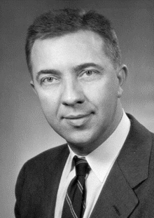
James Alfred Van Allen (September 7, 1914 – August 9, 2006) was an American space scientist at the University of Iowa. He was instrumental in establishing the field of magnetospheric research in space.
The Van Allen radiation belts were named after him, following his discovery using Geiger–Müller tube instruments on the 1958 satellites (Explorer 1, Explorer 3, and Pioneer 3) during the International Geophysical Year. Van Allen led the scientific community in putting scientific research instruments on space satellites. (Full article...)
.jpg.webp)


_(cropped).jpg.webp)


Selected images
 Computer simulation of the Earth's magnetic field in a period of normal polarity between reversals. (from Geophysics)
.svg.png.webp)
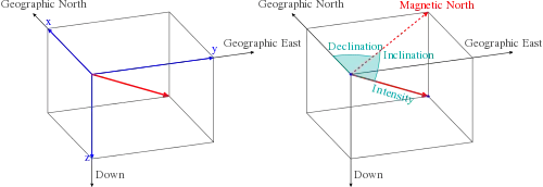 Common coordinate systems used for representing the Earth's magnetic field. (from Earth's magnetic field)
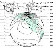 Background: a set of traces from magnetic observatories showing a magnetic storm in 2000.
Globe: map showing locations of observatories and contour lines giving horizontal magnetic intensity in μ T. (from Earth's magnetic field)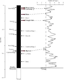 Variations in virtual axial dipole moment since the last reversal. (from Earth's magnetic field)
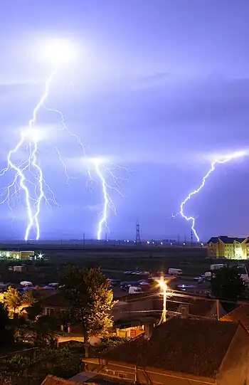 Cloud-to-ground lightning. Typically, lightning discharges 30,000 amperes, at up to 100 million volts, and emits light, radio waves, x-rays and even gamma rays. Plasma temperatures in lightning can approach 28,000 kelvins. (from Atmospheric electricity)
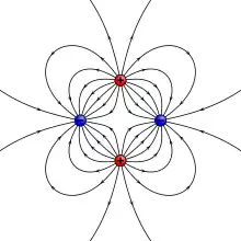 Example of a quadrupole field. This can also be constructed by moving two dipoles together. (from Earth's magnetic field)
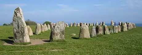 Ale's Stones at Kåseberga, around ten kilometres south east of Ystad, Sweden were dated at 56 CE using the carbon-14 method on organic material found at the site. (from Radiometric dating)
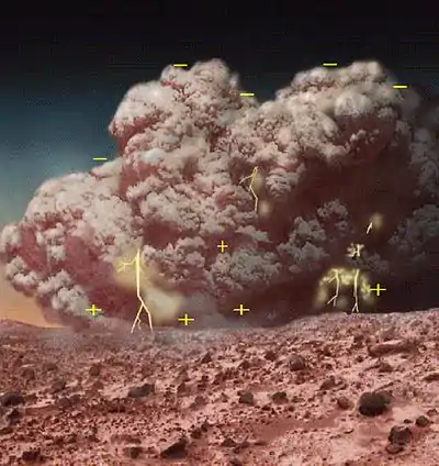 A depiction of atmospheric electricity in a Martian dust storm, which has been suggested as a possible explanation for enigmatic chemistry results from Mars (see also Viking lander biological experiments) (from Atmospheric electricity)
- A schematic illustrating the relationship between motion of conducting fluid, organized into rolls by the Coriolis force, and the magnetic field the motion generates. (from Earth's magnetic field)
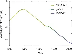 Strength of the axial dipole component of Earth's magnetic field from 1600 to 2020. (from Earth's magnetic field)
 Geomagnetic polarity during the late Cenozoic Era. Dark areas denote periods where the polarity matches today's polarity, light areas denote periods where that polarity is reversed. (from Earth's magnetic field)
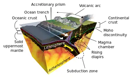 Earth's crust and mantle, Mohorovičić discontinuity between bottom of crust and solid uppermost mantle (from Internal structure of Earth)
- A diagram of Earth's geodynamo and magnetic field, which could have been driven in Earth's early history by the crystallization of magnesium oxide, silicon dioxide, and iron(II) oxide (from Internal structure of Earth)
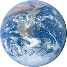
.jpg.webp) A photograph of Earth taken by the crew of Apollo 17 in 1972. A processed version became widely known as The Blue Marble. (from Internal structure of Earth)
A photograph of Earth taken by the crew of Apollo 17 in 1972. A processed version became widely known as The Blue Marble. (from Internal structure of Earth)
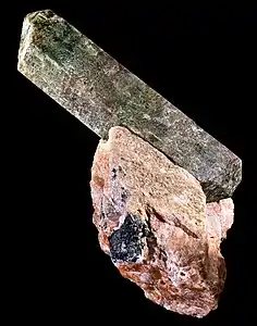 Apatite crystals are widely used in fission track dating. (from Radiometric dating)
 Lightning sequence (Duration: 0.32 seconds) (from Atmospheric electricity)
 Estimated declination contours by year, 1590 to 1990 (click to see variation). (from Earth's magnetic field)
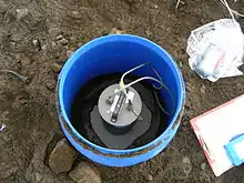 Installation for a temporary seismic station, north Iceland highland. (from Seismology)
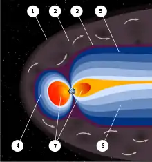 An artist's rendering of the structure of a magnetosphere. 1) Bow shock. 2) Magnetosheath. 3) Magnetopause. 4) Magnetosphere. 5) Northern tail lobe. 6) Southern tail lobe. 7) Plasmasphere. (from Earth's magnetic field)
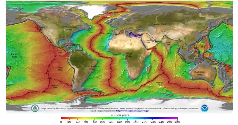
- Age of the sea floor. Much of the dating information comes from magnetic anomalies.
 World map showing frequency of lightning strikes, in flashes per km² per year (equal-area projection). Lightning strikes most frequently in the Democratic Republic of the Congo. Combined 1995–2003 data from the Optical Transient Detector and 1998–2003 data from the Lightning Imaging Sensor. (from Atmospheric electricity)
- Computer simulation of Earth's field in a period of normal polarity between reversals. The lines represent magnetic field lines, blue when the field points towards the center and yellow when away. The rotation axis of Earth is centered and vertical. The dense clusters of lines are within Earth's core. (from Earth's magnetic field)
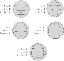 Schematic representation of spherical harmonics on a sphere and their nodal lines. Pℓ m is equal to 0 along m great circles passing through the poles, and along ℓ-m circles of equal latitude. The function changes sign each ℓtime it crosses one of these lines. (from Earth's magnetic field)
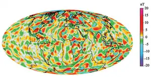 A model of short-wavelength features of Earth's magnetic field, attributed to lithospheric anomalies (from Earth's magnetic field)
_The_role_of_phosphates_for_the_Lu%E2%80%93Hf_chronology_of_meteorites.gif) Lu-Hf isochrons plotted of meteorite samples. The age is calculated from the slope of the isochron (line) and the original composition from the intercept of the isochron with the y-axis. (from Radiometric dating)
Lu-Hf isochrons plotted of meteorite samples. The age is calculated from the slope of the isochron (line) and the original composition from the intercept of the isochron with the y-axis. (from Radiometric dating)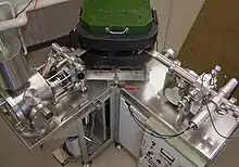 Thermal ionization mass spectrometer used in radiometric dating. (from Radiometric dating)
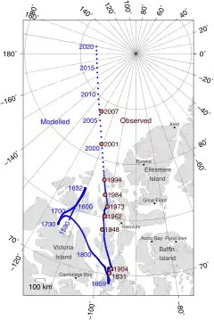 The movement of Earth's North Magnetic Pole across the Canadian arctic. (from Earth's magnetic field)
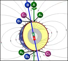 Relationship between Earth's poles. A1 and A2 are the geographic poles; B1 and B2 are the geomagnetic poles; C1 (south) and C2 (north) are the magnetic poles. (from Earth's magnetic field)
 Example of a radioactive decay chain from lead-212 (212Pb) to lead-208 (208Pb) . Each parent nuclide spontaneously decays into a daughter nuclide (the decay product) via an α decay or a β− decay. The final decay product, lead-208 (208Pb), is stable and can no longer undergo spontaneous radioactive decay. (from Radiometric dating)
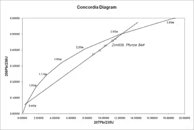 A concordia diagram as used in uranium–lead dating, with data from the Pfunze Belt, Zimbabwe. All the samples show loss of lead isotopes, but the intercept of the errorchron (straight line through the sample points) and the concordia (curve) shows the correct age of the rock. (from Radiometric dating)
- Geological cross section of Earth, showing its internal structure, the atmosphere and hydrosphere. (from Internal structure of Earth)
Subcategories
- Select [►] to view subcategories
Did you know ...?
![]()
- ... that sprites (pictured), large but very brief reddish forms of lightning that occur high over thunderstorms, were not photographed until 1989?
- ... that micrometeorites contribute most of the extraterrestrial material that comes to Earth?
- ...that earthquake lights, although described in 373 BC, were not convincingly documented until the 1960s?
- ... that an instrument used to measure magnetic anomalies was originally developed to detect submarines during World War II?
In the news
- 5 December 2019: Earthquakes on the Cascadia Fault may trigger earthquakes on the San Andreas Fault (Nature)
- 10 December 2019/ 20 January 2020: New evidence suggests Earth's magnetic field was present 3.7 billion years ago (Nature) - or perhaps even 4.2 billion years ago (Science)
- 13 January 2020: Brazil opens "spectacular" research base in Antarctica (Science)
Subtopics
| Overview | |
|---|---|
| Subfields | |
| Physical phenomena | |
| Related disciplines | |
| |
Related portals
Associated Wikimedia
The following Wikimedia Foundation sister projects provide more on this subject:
-
 Commons
Free media repository -
 Wikibooks
Free textbooks and manuals -
 Wikidata
Free knowledge base -
 Wikinews
Free-content news -
 Wikiquote
Collection of quotations -
 Wikisource
Free-content library -
 Wikiversity
Free learning tools -
 Wiktionary
Dictionary and thesaurus
-
 List of all portalsList of all portals
 -
 The arts portal
 -
 Biography portal
 -
 Current events portal
 -
 Geography portal
 -
 History portal
 -
 Mathematics portal
 -
 Science portal
 -
 Society portal
 -
 Technology portal
 -
 Random portalRandom portal
 -
 WikiProject PortalsWikiProject Portals