Picos, Cape Verde
Picos, also known as Achada Igreja, is a city[2] in the central part of the island of Santiago, Cape Verde. It is the seat of São Salvador do Mundo municipality. Picos is located 4 km southeast of Assomada and 23 km northwest of the capital city of Praia, near the national road from Praia to Tarrafal via Assomada (EN1-ST01).
Picos | |
|---|---|
Settlement | |
 | |
 Picos | |
| Coordinates: 15.083°N 23.632°W | |
| Country | Cape Verde |
| Island | Santiago |
| Municipality | São Salvador do Mundo |
| Civil parish | São Salvador do Mundo |
| Population (2010)[1] | |
| • Total | 986 |
| ID | 77102 |
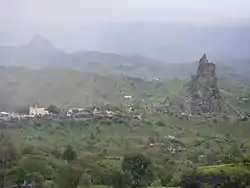
Picos is surrounded by mountains, and lies about 4 km north of the highest peak of the island of Santiago, Pico de Antónia.

São Salvador do Mundo church
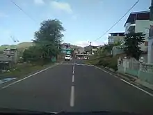
Downtown Achada Igreja
History
Picos was the seat of the municipality of Santa Catarina between 1834 and 1859.[3] In May 2005, the parish of São Salvador do Mundo was split from the municipality of Santa Catarina to become a separate municipality, and Picos became its seat.[4]
References
- "2010 Census results". Instituto Nacional de Estatística Cabo Verde (in Portuguese). 24 November 2016.
- Cabo Verde, Statistical Yearbook 2015, Instituto Nacional de Estatística, p. 32-33
- Evolução histórica do Concelho de Santa Catarina (1834 – 1912), Ana Zenaida Gomes, 2005, p. 37-38
- Lei nº 65/VI/2005, p. 43
External links
Wikimedia Commons has media related to Picos (Cape Verde).
- Plano comunal de São Salvador do Mundo (May 2009, p. 28) (in Portuguese)
This article is issued from Wikipedia. The text is licensed under Creative Commons - Attribution - Sharealike. Additional terms may apply for the media files.