Pantops, Virginia
Pantops is a census-designated place in Albemarle County, Virginia.[1]
Pantops | |
|---|---|
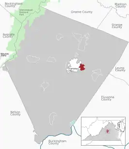 Location of the Pantops CDP within the Albemarle county | |
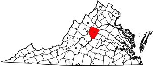
 Pantops Location within the Commonwealth of Virginia | |
| Coordinates: 38°1′51″N 78°26′41″W | |
| Country | United States |
| State | Virginia |
| County | Albemarle |
| Population (2020) | |
| • Total | 4,682 |
| Time zone | UTC−5 (Eastern (EST)) |
| • Summer (DST) | UTC−4 (EDT) |
| ZIP codes | 22911 |
| FIPS code | 51-60500 |
| GNIS feature ID | 2584899 |
Geography
It is a suburban area located just across the Rivanna River east of Charlottesville, and includes Pantops Mountain.
Demographics
| Census | Pop. | Note | %± |
|---|---|---|---|
| 2010 | 3,027 | — | |
| 2020 | 4,682 | 54.7% | |
| U.S. Decennial Census 2010[2] 2020[3] | |||
The population as of the 2010 Census was 3,027.
References
- "Pantops Census Designated Place". Geographic Names Information System. United States Geological Survey, United States Department of the Interior. Retrieved August 13, 2013.
- "P2 HISPANIC OR LATINO, AND NOT HISPANIC OR LATINO BY RACE - 2010: DEC Redistricting Data (PL 94-171) - Pantops CDP, Virginia". United States Census Bureau.
- "P2 HISPANIC OR LATINO, AND NOT HISPANIC OR LATINO BY RACE - 2020: DEC Redistricting Data (PL 94-171) - Pantops CDP, Virginia". United States Census Bureau.
Wikimedia Commons has media related to Pantops, Virginia.
This article is issued from Wikipedia. The text is licensed under Creative Commons - Attribution - Sharealike. Additional terms may apply for the media files.