Pancé
Pancé (French pronunciation: [pɑ̃se]; Breton: Pantieg; Gallo: Panczaé) is a commune in the Ille-et-Vilaine department of Brittany in northwestern France.
Pancé
Pantieg | |
|---|---|
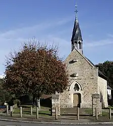 The chapel of Saint-Melaine | |
Location of Pancé | |
 Pancé  Pancé | |
| Coordinates: 47°52′56″N 1°39′25″W | |
| Country | France |
| Region | Brittany |
| Department | Ille-et-Vilaine |
| Arrondissement | Redon |
| Canton | Bain-de-Bretagne |
| Intercommunality | Bretagne Porte de Loire |
| Government | |
| • Mayor (2020–2026) | Jean-François Pilard[1] |
| Area 1 | 19.33 km2 (7.46 sq mi) |
| Population | 1,196 |
| • Density | 62/km2 (160/sq mi) |
| Time zone | UTC+01:00 (CET) |
| • Summer (DST) | UTC+02:00 (CEST) |
| INSEE/Postal code | 35212 /35320 |
| Elevation | 17–105 m (56–344 ft) |
| 1 French Land Register data, which excludes lakes, ponds, glaciers > 1 km2 (0.386 sq mi or 247 acres) and river estuaries. | |
Geography
The river Semnon forms all of the commune's southern border.
Population
Inhabitants of Pancé are called Pancéens in French.
| Year | Pop. | ±% |
|---|---|---|
| 1962 | 669 | — |
| 1968 | 725 | +8.4% |
| 1975 | 689 | −5.0% |
| 1982 | 763 | +10.7% |
| 1990 | 794 | +4.1% |
| 1999 | 964 | +21.4% |
| 2008 | 1,124 | +16.6% |
References
- "Répertoire national des élus: les maires" (in French). data.gouv.fr, Plateforme ouverte des données publiques françaises. 13 September 2022.
- "Populations légales 2020". The National Institute of Statistics and Economic Studies. 29 December 2022.
External links
Wikimedia Commons has media related to Pancé.
- Base Mérimée: Search for heritage in the commune, Ministère français de la Culture. (in French)
- Mayors of Ille-et-Vilaine Association (in French)
This article is issued from Wikipedia. The text is licensed under Creative Commons - Attribution - Sharealike. Additional terms may apply for the media files.