Palm Island (Miami Beach)
Palm Island is a neighborhood in the city of Miami Beach on a man-made island in Biscayne Bay, Florida, United States;[1] just south of Hibiscus Island. It is a residential neighborhood with high property values, solely accessible by land via the MacArthur Causeway. The entire island has an area of 82 acres (33 ha).
Palm Island | |
|---|---|
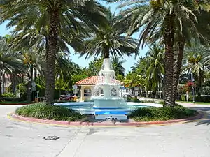 Fountain and guard gate at the entrance to Palm Island in Miami Beach from the MacArthur Causeway | |
| Country | United States |
| State | Florida |
| County | Miami-Dade County |
| City | Miami Beach |
| Government | |
| • Miami Beach Mayor | Dan Gelber |
| • Miami-Dade County Commissioner | Bruno Barreiro |
| • House of Representatives | Fabián Basabe (R) |
| • State Senate | Ileana Garcia (R) |
| • U.S. House | Frederica Wilson (D) |
| Area | |
| • Total | 0.129 sq mi (0.33 km2) |
| • Land | 0.129 sq mi (0.33 km2) |
| • Water | 0.0 sq mi (0 km2) 0.0% |
| Population (2010) | |
| • Total | 329 |
| Time zone | UTC−5 (EST) |
| ZIP Code | 33139 |
| Area code(s) | 305, 786 |
Education
Palm Island is zoned to schools in the Miami-Dade County Public Schools.
Zoned schools include:
- South Pointe Elementary School[2]
- Nautilus Middle School
- Miami Beach High School
Notable people
Gallery
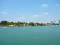 Palm Island as seen from Hibiscus Island
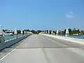 Bridge connecting Hibiscus & Palm Islands
References
- "Palm Island | Luxury Waterfront Neighborhood in Miami Beach, Florida". Miami Luxury Homes. Retrieved 2020-03-24.
- "South Pointe Elementary School". Archived from the original on 2008-01-11. Retrieved 2007-08-24.
- Florida Atlas & Gazetteer (Third ed.) (1989). Freeport, ME: DeLorme Mapping.
External links
Junctions of the MacArthur Causeway | ||||
|---|---|---|---|---|
| ||||
This article is issued from Wikipedia. The text is licensed under Creative Commons - Attribution - Sharealike. Additional terms may apply for the media files.