Pak Sha Chau (Sai Kung District)
Pak Sha Chau (Chinese: 白沙洲; pinyin: Báishā Zhōu; lit. 'White Sand Island') is an island of Hong Kong. Administratively, it is part of the Sai Kung District. Additionally it is part of the Kiu Tsui Country Park.
Native name: 鴨洲 | |
|---|---|
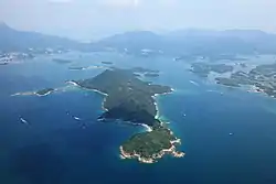 Pak Sha Chau is the small island with tombolo located to the Northwest of Kiu Tsui Chau (Sharp Island) the biggest island centered in the photo. | |
| Administration | |
| Districts | Sai Kung District |
| Demographics | |
| Population | 0 |
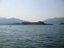
Pak Sha Chau (centre) viewed from the South. Siu Tsan Chau is the small island on the right.
The island is connected to a smaller island, Siu Tsan Chau (小鏟洲), by a tombolo.
See also
Wikimedia Commons has media related to Pak Sha Chau (Sai Kung).
- List of islands and peninsulas of Hong Kong
- Port Shelter, the water body that surrounding the island
This article is issued from Wikipedia. The text is licensed under Creative Commons - Attribution - Sharealike. Additional terms may apply for the media files.