Onstwedde
Onstwedde (Dutch pronunciation: [ɔnstˈʋɛdə]) is a village in the region of Westerwolde and part of Groningen in the Netherlands. It is located in the municipality of Stadskanaal.
Onstwedde | |
|---|---|
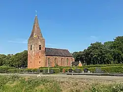
 Nicolaas Church in 2008 | |
 Onstwedde Location of Onstwedde in the province of Groningen  Onstwedde Onstwedde (Netherlands) | |
| Coordinates: 53°2′7″N 7°2′28″E | |
| Country | Netherlands |
| Province | Groningen |
| Municipality | Stadskanaal |
| Established | 875 |
| Area | |
| • Total | 40.57 km2 (15.66 sq mi) |
| Elevation | 5 m (16 ft) |
| Population (2021)[1] | |
| • Total | 2,960 |
| • Density | 73/km2 (190/sq mi) |
| Postal code | 9591 |
| Area code | 0599 |
| Website | www.onstwedde.info |
Onstwedde was also the former name of the municipality of Stadskanaal, until 1969.[3]
History
Onstwedde was first mentioned in 875 as Uneswido in documents of the Werden Abbey.[4] The name means the forest (-wido similar to the English wood) of Une (first name).[5] The village is a double esdorp, a communal pasture surrounded by houses. The northern pasture was called Wold, and the southern pasture Loug.[6] Onstwedde was a part of Westerwolde, a region dominated by raised bogs which formed the natural border between Groningen, East Frisia and the Prince-Bishopric of Münster.[7][8] Onstwedde is located in the valley of the Mussel-Aa river,[6] and was a fertile island surrounded by bogs on all sides.[4]
A dominant feature of Onstwedde is the Nicolaas Church which was constructed around 1500. It has a 41 metres (135 ft) tall tower. The walls are 2 metres (6 ft 7 in) thick, and it used to be surrounded by a moat and could be accessed via a drawbridge. It is assumed that the church was also used as a fortification.[8]
Onstwedde used to be the main village of the region.[6] In 1765, the city of Groningen started to dig the Stadskanaal to the south of Onstwedde in order to exploit the peat.[9] In 1840, the population of Onstwedde was 2,405 people,[8] and Stadskanaal had 1,980 inhabitants.[9] Stadskanaal soon surpassed Onstwedde, and in 1882, the town hall was moved to Stadskanaal.[6] In 1969, the municipality was renamed Stadskanaal.[9]
On 20 April 1943, the Royal Canadian Air Force bomber Mosquito II crashed and burnt in Smeerling near Onstwedde. The crew members are buried in a Commonwealth War Grave on the municipal cemetery.[10]
Education
The two elementary schools of Onstwedde merged into a single entity. Since 2011, the kindergarten, elementary school and high school moved into MFA De Bast, a single building. Onstwedde is one of the few places in the Netherlands where all educational facilities are concentrated in a single building.[4]
Smeerling

The hamlet of Smeerling is located on the road to Vlagtwedde.[11] It contains about ten houses and is home to approximately 25 people, and is considered a part of Onstwedde for statistical and postal services.[12]
There are eight farms in the hamlet which are in similar condition to the 1830 situation.[13] Five of the farms are monuments,[12] the others are from a later date, but traditionally constructed and match the surroundings. In 1972, the entire hamlet was designated a protected monument.[13] The protected area measures 91.6 hectares (226 acres). A two kilometre path has been constructed through the hamlet, forests and meadows of Smeerling.[12]
Notable people
- Henk Bleker (born 1953), Dutch politician[14]
- Izaak Reijnders (1879–1966), Dutch general[15]
Gallery
 Former town hall
 Post mill (1936)
 Pagediep, a remnant of the former bogs
References
- "Kerncijfers wijken en buurten 2021". Central Bureau Statistics. Retrieved 26 February 2022.
- "Postcodetool for 9591AA". Actueel Hoogtebestand Nederland (in Dutch). Het Waterschapshuis. Retrieved 26 February 2022.
- Ad van der Meer and Onno Boonstra, Repertorium van Nederlandse gemeenten, KNAW, 2011.
- "Onstwedde - Het dorp". Onstwedde (in Dutch). Retrieved 26 February 2022.
- "Onstwedde - (geografische naam)". Etymologie Bank (in Dutch). Retrieved 26 February 2022.
- Redmer Alma (1998). "Onstwedde". Zwolle: Waanders Uitgevers. p. 180. ISBN 90 400 9258 3.
- Bosgra, W.H. (1930). Uit Pekela's verleden (in Dutch). Oude Pekela: Feringa. pp. 9–11. Retrieved 26 February 2022.
- "Onstwedde". Plaatsengids (in Dutch). Retrieved 26 February 2022.
- "Stadskanaal". Plaatsengids (in Dutch). Retrieved 26 February 2022.
- "Commonwealth War Graves Municipal Cemetery". Traces of War. Retrieved 26 February 2022.
- G. Herwig; R.H. Herwig (1907). Geïllustreerde gids voor Westerwolde. Unknown. p. 6.
- "Smeerling". Plaatsengids (in Dutch). Retrieved 1 March 2022.
- "Smeerling" (PDF). Rijksdienst voor het Cultureel Erfgoed (in Dutch). 11 September 1972. Retrieved 1 March 2022.
- "Dr. H. (Henk) Bleker". Dutch Parliament (in Dutch). Retrieved 26 February 2022.
- "Reijnders, Izaak Herman (1879-1966)". Huygens Institute for the History of the Netherlands (in Dutch). 2013. Retrieved 26 February 2022.