Ola, South Dakota
Ola is an unincorporated community and census-designated place in Brule County, South Dakota, United States. The population was 15 according to the 2020 census.[4]
Ola, South Dakota | |
|---|---|
 Ola Location within the state of South Dakota | |
| Coordinates: 43°36′02″N 99°12′41″W | |
| Country | United States |
| State | South Dakota |
| Counties | Brule |
| Area | |
| • Total | 4.02 sq mi (10.41 km2) |
| • Land | 4.02 sq mi (10.41 km2) |
| • Water | 0.00 sq mi (0.00 km2) |
| Elevation | 1,732 ft (528 m) |
| Population | |
| • Total | 15 |
| • Density | 3.73/sq mi (1.44/km2) |
| Time zone | UTC-6 (Central (CST)) |
| • Summer (DST) | UTC-5 (CDT) |
| FIPS code | 46-46700 |
| GNIS feature ID | 2584564[2] |
The CDP is located in southern Brule County, 2 miles (3 km) west of South Dakota Highway 50 and 12 miles (19 km) south of Interstate 90.
References
- "ArcGIS REST Services Directory". United States Census Bureau. Retrieved October 15, 2022.
- U.S. Geological Survey Geographic Names Information System: Ola, South Dakota
- "Census Population API". United States Census Bureau. Retrieved October 15, 2022.
- "U.S. Census Bureau: Ola CDP, South Dakota". www.census.gov. United States Census Bureau. Retrieved June 27, 2022.
- "Census of Population and Housing". Census.gov. Retrieved June 4, 2016.
Municipalities and communities of Brule County, South Dakota, United States | ||
|---|---|---|
| Cities | 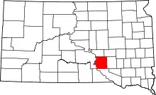 | |
| Town | ||
| CDPs | ||
| Other community | ||
| Townships |
| |
| Unorganized Territory |
| |
This article is issued from Wikipedia. The text is licensed under Creative Commons - Attribution - Sharealike. Additional terms may apply for the media files.