Oahe Acres, South Dakota
Oahe Acres is an unincorporated community and census-designated place (CDP) in Hughes County, South Dakota, United States. It was first listed as a CDP prior to the 2020 census.[2] The population of the CDP was 503 at the 2020 census.[4]
Oahe Acres, South Dakota | |
|---|---|
 Oahe Acres  Oahe Acres | |
| Coordinates: 44°27′53″N 100°20′42″W | |
| Country | United States |
| State | South Dakota |
| County | Hughes |
| Area | |
| • Total | 1.32 sq mi (3.42 km2) |
| • Land | 1.32 sq mi (3.42 km2) |
| • Water | 0.00 sq mi (0.00 km2) |
| Elevation | 1,729 ft (527 m) |
| Population | |
| • Total | 503 |
| • Density | 380.77/sq mi (147.03/km2) |
| Time zone | UTC-6 (Central (CST)) |
| • Summer (DST) | UTC-5 (CDT) |
| ZIP Code | 57501 (Pierre) |
| Area code | 605 |
| FIPS code | 46-46240 |
| GNIS feature ID | 2813032[2] |
It is in the northwest part of the county, 7 miles (11 km) north of Pierre, the state capital, and 2 miles (3 km) east of Oahe Dam on the Missouri River.
References
- "ArcGIS REST Services Directory". United States Census Bureau. Retrieved October 15, 2022.
- U.S. Geological Survey Geographic Names Information System: Oahe Acres, South Dakota
- "Census Population API". United States Census Bureau. Retrieved October 15, 2022.
- "U.S. Census Bureau: Oahe Acres CDP, South Dakota". www.census.gov. United States Census Bureau. Retrieved December 28, 2021.
- "Census of Population and Housing". Census.gov. Retrieved June 4, 2016.
Municipalities and communities of Hughes County, South Dakota, United States | ||
|---|---|---|
| Cities | 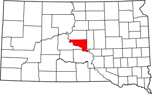 Hughes County map | |
| Town | ||
| Township | ||
| Indian reservation | ||
| CDP | ||
| Other communities | ||
| Footnotes | ‡This populated place also has portions in an adjacent county or counties | |
This article is issued from Wikipedia. The text is licensed under Creative Commons - Attribution - Sharealike. Additional terms may apply for the media files.