Nyrölä
Nyrölä is a district and neighbourhood of Jyväskylä, Finland located 30 kilometres (19 mi) from the city centre. Prior to 2009, it was one of the villages of Jyväskylän maalaiskunta.
Nyrölä | |
|---|---|
District of Jyväskylä | |
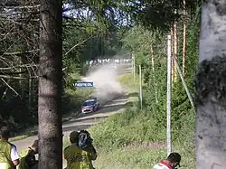
 Dani Sordo during Rally Finland in Mökkiperä, Nyrölä | |
 Nyrölä Location in Central Finland | |
| Coordinates: 62°21′47.05″N 25°28′59.27″E | |
| Country | |
| Region | Central Finland |
| Sub-region | Jyväskylä sub-region |
| City | Jyväskylä |
| Ward | Tikkakoski-Nyrölä |
| Population (2021-12-31) | |
| • Total | 282 (incl. Sikomäki)[1] |
| Time zone | UTC+2 (EET) |
| • Summer (DST) | UTC+3 (EEST) |
| Postal code | 40740 JYVÄSKYLÄ |
An amateur astronomical observatory Nyrölä Observatory is located in Nyrölä. Mökkiperä Stage of Rally Finland is driven in Nyrölä.
Geography
Nyrölä is located in the northwestern part of Jyväskylä, mostly in a salient between Petäjävesi and Uurainen. It also includes the areas of Mökkiperä and Hepoperä. The statistical sub-district (pienalue) of Nyrölä also includes Sikomäki, which is not a part of the development district (kaupunginosa) and belongs to the Kuikka district instead.[2] However, Sikomäki was a part of the register village of Nyrölä.[3]
History
Nyrölä was established around 1565.[4] Its name is derived from the Savonian surname Nyrönen, first recorded here in 1570 (Juho Nyröinen).[5] The village has also been called Soukkajärvi, referring to the lakes Iso-Soukka and Pikku-Soukka.[6][7] In 1593, there were two estates in Nyrölä, both of which were owned by Savonians.[8]
The chapel community of Jyväskylä within Laukaa was established around 1693 and Nyrölä (Soukkajärvi) became one of its villages.[9] The Jyväskylä parish was separated from Laukaa in 1856.[6][10] The territories of the Jyväskylä parish outside the town of Jyväskylä became the municipality of Jyväskylän maalaiskunta in 1868.[11] In the same year, Uurainen was separated from Saarijärvi and the northern part of Nyrölä was transferred to Uurainen, as the locals had been requesting the transfer since 1853.[6]
A highway to Vesanka was finished in 1902, followed by one to Kuikka in 1936.[4]
After Jyväskylän maalaiskunta was consolidated with the town of Jyväskylä in 2009, Nyrölä became one of its districts.
Services
School
The Nyrölä school was established in 1896 and was closed in 2016, when the school only had 16 students. After the school was closed, they were transferred to the united school (grades 1-9) at Tikkakoski.[12] Since 2019, the building has been used as a community building called Nyrölätalo.[13]
References
- "Tilastokeskus - Jyväskylän väestö pienalueittain". app.powerbi.com (in Finnish). Retrieved April 14, 2023.
- "Jyväskylän karttapalvelu". kartta.jkl.fi (in Finnish). Retrieved April 14, 2023.
- Lappalainen, Jussi T. (1977). Jyväskylän maalaiskunnan kirja (in Finnish). Jyväskylä: Jyväskylän maalaiskunta ja maaseurakunta. p. 38-39. ISBN 951-99104-3-3.
- "Nyrölän kylä - Nyrölä". nyrola.fi (in Finnish). Retrieved April 14, 2023.
- Jyväskylän maalaiskunnan kirja, page 538.
- Jyväskylän maalaiskunnan kirja, pages 52-53.
- "Ilmari Kosonen: Paikannimien taustat paljastuvat - Suur-Jyväskylän lehti" (PDF). surkkari.fi (in Finnish). Archived from the original (PDF) on December 8, 2015. Retrieved April 14, 2023.
- Jyväskylän maalaiskunnan kirja, page 14.
- Jyväskylän maalaiskunnan kirja, page 46.
- "Suomen Sukututkimusseura - Jyväskylän maaseurakunta". hiski.genealogia.fi (in Finnish). Retrieved April 13, 2023.
- "SuomalainenPaikannimikirja_e-kirja_kuvallinen.pdf" (PDF). kaino.kotus.fi (in Finnish). p. 115. Retrieved April 14, 2023.
- "Nyrölän koulu lakkautetaan - Yle Uutiset". yle.fi (in Finnish). Retrieved April 14, 2023.
- "Historia - Nyrölätalo". nyrolatalo.fi (in Finnish). Retrieved April 14, 2023.
External links
- Official website (in Finnish)
- Nyrölä Observatory
