North Merritt Island, Florida
North Merritt Island is a census-designated place (CDP) in Brevard County, Florida, United States. It occupies a portion of the physical Merritt Island, north of the CDP of Merritt Island and south of Merritt Island National Wildlife Refuge. Florida State Road 3 is the main highway through the community, leading north to Florida State Road 405 and south to Florida State Road 528.
North Merritt Island, Florida | |
|---|---|
 North Merritt Island  North Merritt Island | |
| Coordinates: 28°27′24″N 80°42′34″W | |
| Country | |
| State | Florida |
| County | Brevard |
| Area | |
| • Total | 28.79 sq mi (74.56 km2) |
| • Land | 16.86 sq mi (43.66 km2) |
| • Water | 11.93 sq mi (30.90 km2) |
| Elevation | 5 ft (2 m) |
| Population (2020) | |
| • Total | 8,566 |
| • Density | 508.13/sq mi (196.19/km2) |
| Time zone | UTC-5 (Eastern (EST)) |
| • Summer (DST) | UTC-4 (EDT) |
| ZIP Code | 32953 (Merritt Island) |
| Area code | 321 |
| FIPS code | 12-49435 |
| GNIS feature ID | 2805180[2] |
North Merritt Island was first listed as a CDP prior to the 2020 census.
References
- "2020 U.S. Gazetteer Files". United States Census Bureau. Retrieved October 31, 2021.
- "North Merritt Island Census Designated Place". Geographic Names Information System. United States Geological Survey, United States Department of the Interior.
- "Census of Population and Housing". Census.gov. Retrieved June 4, 2016.
Municipalities and communities of Brevard County, Florida, United States | ||
|---|---|---|
| Cities | 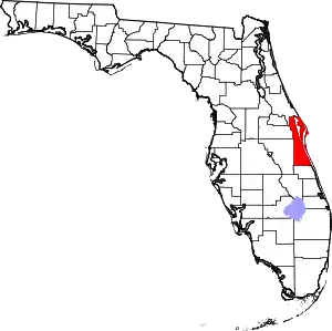 | |
| Towns | ||
| CDPs | ||
| Unincorporated communities | ||
| Ghost towns | ||
This article is issued from Wikipedia. The text is licensed under Creative Commons - Attribution - Sharealike. Additional terms may apply for the media files.