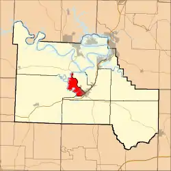
Niangua Township, Camden County, Missouri
Niangua Township is one of eleven townships in Camden County, Missouri, USA. As of the 2000 census, its population was 3,356.
Niangua Township | |
|---|---|
 | |
| Coordinates: 38°01′19″N 092°48′36″W | |
| Country | United States |
| State | Missouri |
| County | Camden |
| Area | |
| • Total | 20.7 sq mi (53.62 km2) |
| • Land | 17.34 sq mi (44.91 km2) |
| • Water | 3.36 sq mi (8.71 km2) 16.24% |
| Elevation | 748 ft (228 m) |
| Population (2000) | |
| • Total | 3,356 |
| • Density | 193.5/sq mi (74.7/km2) |
| FIPS code | 29-52410[2] |
| GNIS feature ID | 0767575 |
The township was named after the Niangua River.[3]
Geography
Niangua Township covers an area of 20.7 square miles (54 km2) and contains one incorporated settlement, Camdenton (the county seat). It contains three cemeteries: Laughlin, Tick Ridge and Union Electric.
References
- "US Board on Geographic Names". United States Geological Survey. October 25, 2007. Retrieved January 31, 2008.
- "U.S. Census website". United States Census Bureau. Retrieved January 31, 2008.
- "Camden County Place Names, 1928–1945 (archived)". The State Historical Society of Missouri. Archived from the original on June 24, 2016. Retrieved September 8, 2016.
{{cite web}}: CS1 maint: bot: original URL status unknown (link)
External links
Municipalities and communities of Camden County, Missouri, United States | ||
|---|---|---|
| Cities | 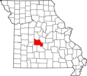 Map of Missouri highlighting Camden County | |
| Villages | ||
| Townships | ||
| CDPs | ||
| Other communities | ||
| Footnotes | ‡This populated place also has portions in an adjacent county or counties | |
This article is issued from Wikipedia. The text is licensed under Creative Commons - Attribution - Sharealike. Additional terms may apply for the media files.