Napoleons, Victoria
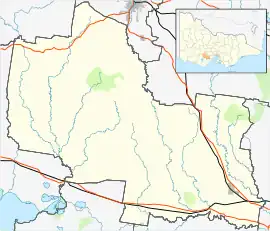
Napoleons is a town in Victoria, Australia in the Golden Plains Shire local government area, 131 kilometres (81 mi) west of the state capital, Melbourne. At the 2016 census, Napoleons had a population of 553.[1]
| Napoleons Victoria | |||||||||||||||
|---|---|---|---|---|---|---|---|---|---|---|---|---|---|---|---|
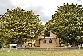
 The historic Black Lead church, now home to Napoleons District Historical Society | |||||||||||||||
 Napoleons | |||||||||||||||
| Coordinates | 37°41′0″S 143°50′0″E | ||||||||||||||
| Population | 553 (2016 census)[1] | ||||||||||||||
| Postcode(s) | 3352[2] | ||||||||||||||
| Location | |||||||||||||||
| LGA(s) | Golden Plains Shire | ||||||||||||||
| State electorate(s) | Ripon | ||||||||||||||
| Federal division(s) | Wannon | ||||||||||||||
| |||||||||||||||
The Post Office opened on 1 September 1862, was known as Napoleon until around 1950, and closed in 1971.[3] A Community Postal Agency opened at the Napoleons store on 17 April 2012.
The town is served by Napoleons Primary School, with an enrolment of 102. The current school opened in 2002. The original school, situated nearby, opened in 1870.[4]
References
Wikimedia Commons has media related to Napoleons, Victoria.
- Australian Bureau of Statistics (27 June 2017). "Napoleons (State Suburb)". 2016 Census QuickStats. Retrieved 31 August 2017.
- Napoleons Postcode Australia Post
- Phoenix Auctions History. "Post Office List". Retrieved 19 March 2021.
- "Napoleons primary school history". Napoleons Primary School. Retrieved 28 November 2020.
This article is issued from Wikipedia. The text is licensed under Creative Commons - Attribution - Sharealike. Additional terms may apply for the media files.