Central Luzon Link Expressway
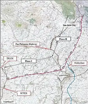
The Central Luzon Link Expressway (CLLEX), also known as the Central Luzon Link Freeway,[3] is a partially operational expressway[4] in the Central Luzon region of the Philippines. It will connect the Subic–Clark–Tarlac Expressway (SCTEX) and the Tarlac–Pangasinan–La Union Expressway (TPLEX) to the currently under-construction North Luzon East Expressway in Cabanatuan[1] towards San Jose, Nueva Ecija.[2] It is currently toll-free and exclusively open to Class 1 vehicles[lower-alpha 1] but it will be tolled and opened to other classes of vehicles in the future.[2]
.svg.png.webp) | |
|---|---|
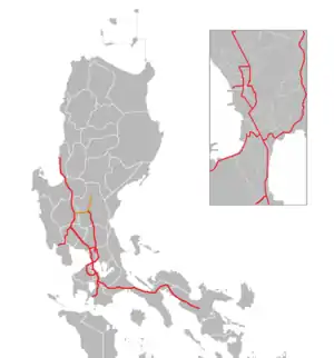
 A map of expressways in Luzon, with CLLEX in orange | |
| Route information | |
| Length | 66.4 km (41.3 mi)
|
| Existed | 2021–present |
| Component highways | |
| Major junctions | |
| West end | |
| |
| East end | |
| Location | |
| Country | Philippines |
| Provinces | |
| Major cities | |
| Towns | |
| Highway system | |
| |
The untolled section from Tarlac City to La Paz is designated as National Route 308 (N308) of the Philippine highway network.[5]
Route description

CLLEX runs in an east-west direction from Tarlac City to San Jose, Nueva Ecija. The entire route is built as a four-lane expressway mostly laid out on embankment.
Phase 1
From the west, CLLEX begins at a trumpet interchange with the Subic–Clark–Tarlac Expressway (SCTEX) and Tarlac–Pangasinan–La Union Expressway (TPLEX) in Tarlac City. The expressway intersects Santa Rosa–Tarlac Road at a diamond interchange where the expressway passes above grade. The expressway then passes agricultural land, before turning east as it enters La Paz. It crosses La Paz–Victoria Road where an interchange serving entering westbound vehicles and exiting eastbound vehicles, connects the two. The expressway continues east as it crosses through a viaduct over the Rio Chico River, and crosses the Tarlac–Nueva Ecija boundary before crossing the Talavera River.
The expressway then continues east as it enters Zaragoza, Nueva Ecija. It turns northeast as it meets Zaragoza interchange, a trumpet interchange connecting with Zaragoza–Aliaga Road. It makes a reverse curve turning southeast before crossing Guimba–Aliaga Road as it enters Aliaga, where a temporary exit is built as the expressway's current terminus.
History
In 2010, the Japan International Cooperation Agency (JICA) formulated the creation of an expressway network under the High Standard Highway Network Development Master Plan, focusing on a growth area within the 200 km (120 mi) radium sphere of Metro Manila. The DPWH, under JICA's assistance, completed the feasibility study for the proposed Central Luzon Expressway (CLEX) on the same year.
The proposed project was to divided into two (2) phases: Phase 1 with a 30.7 km (19.1 mi) network beginning from the connection of SCTEX and TPLEX in Balingcanaway, Tarlac City and ends at the Pan-Philippine Highway (Daang Maharlika) in Caalibangbangan, Cabanatuan; and Phase 2 with 35.7 km (22.2 mi) network beginning from the Phase 1 terminus in Cabanatuan and ends at San Jose town proper.[6]
The project was renamed to Central Luzon Link Expressway (CLLEX) in 2011 after the preparatory survey and final report plan for Phase 1 was concluded.[7]
The Japan International Cooperation Agency (JICA) would fund the construction of the 66.4-kilometer (41.3 mi) CLLEX, while operation and maintenance would be under the Public-Private Partnership (PPP) scheme. The construction of the CCLEX Phase 1 project was funded thru the Official Development Assistance (Japan) grant of ¥22,796,000,000 (₱11.87 billion, March 2012 exchange rate) at a signing agreement ceremony by the Foreign Affairs Secretary Alberto Romulo and Japanese Ambassador to the Philippines Toshinao Urabe.[8]
In the President Benigno Aquino III's State of the Nation address in 2014, the CLLEX was one of many of the administration's priority projects involving massive infrastructure spending in Central Luzon.[9]
The groundbreaking ceremony was held on September 22, 2017, along with the beginning of construction.[10] The expressway was originally planned to open in December 2020, but was repeatedly delayed due to the COVID-19 pandemic.
The first 18 kilometers (11 mi) of the expressway from Tarlac City to Aliaga was inaugurated by President Rodrigo Duterte on July 15, 2021. The expressway opened to vehicles on the same day.[11]
In July 2022, DPWH announced that CLLEX will be completed by July 2023. The current Phase 1 terminus in Aliaga will see an extension of seven kilometers up to San Juan Interchange and four kilometers to Umangan–Julo Road, before ending at Felipe Vergara Highway and the Pan–Philippine Highway.[12]
Exits
This entire route is located in Central Luzon. Exits will be numbered by kilometer posts, with Rizal Park in Manila designated as kilometer zero.
| Province | City/Municipality | km | mi | Exit | Name | Destinations | Notes |
|---|---|---|---|---|---|---|---|
| Tarlac | Tarlac City | 122A 122B | Tarlac City | Hybrid trumpet and diamond interchange; western terminus[13] | |||
| La Paz | La Paz | La Paz–Victoria Road | Eastbound entrance only. Future directional T interchange. Change from N308 to unnumbered. | ||||
| Nueva Ecija | Zaragoza | Zaragoza | Future trumpet interchange | ||||
| Aliaga | Aliaga | Guimba–Aliaga Road | Temporary half-diamond interchange, current eastern terminus | ||||
| Aliaga | Guimba–Aliaga Road | Future trumpet interchange | |||||
| San Juan | Carmen–Cabanatuan Road | Half trumpet interchange; eastbound exit and westbound entrance | |||||
| Cabanatuan | Cabanatuan | Future eastern end of Phase 1 | |||||
| NLEE | North Luzon East Expressway | ||||||
| General Mamerto Natividad | Gen. M. Natividad | ||||||
| Llanera | Llanera | ||||||
| San Jose | San Jose toll plaza (Cash payments) | ||||||
| San Jose City | Future eastern terminus; end of Phase 2. | ||||||
1.000 mi = 1.609 km; 1.000 km = 0.621 mi
| |||||||
Notes
- As seen on some YouTube videos, restriction barriers were placed on every ramp of the expressway, preventing the entry of tall and wide vehicles. This could explain the reason why the expressway is currently toll-free and exclusively open to light vehicles.
References
- "CENTRAL LUZON LINK EXPRESSWAY (CLLEx) Phase I | Department of Public Works and Highways". Department of Public Works and Highways.
- "CENTRAL LUZON LINK EXPRESSWAY (CLLEx) Phase II (CABANATUAN-SAN JOSE, NUEVA ECIJA) | Department of Public Works and Highways". Department of Public Works and Highways.
- Patinio, Ferdinand (July 23, 2021). "'Build, Build, Build': Paving the way to progress". Philippine News Agency. Archived from the original on 2021-07-23. Retrieved 2021-08-10.
- "DPWH to Open CLLEX up to Aliaga, Nueva Ecija by May 15". Department of Public Works and Highways. February 15, 2021.
- "ArcGIS Web Application".
- "PREPARATORY SURVEY FOR EXPRESSWAY PROJECTS IN MEGA MANILA REGION - CENTRAL LUZON LINK EXPRESSWAY PROJECT (Phase I)" (PDF). openjicareport.jica.go.jp. Retrieved March 17, 2022.
- "PREPARATORY SURVEY FOR EXPRESSWAY PROJECTS IN MEGA MANILA REGION - CENTRAL LUZON LINK EXPRESSWAY PROJECT (Phase I)" (PDF). openjicareport.jica.go.jp. Retrieved June 7, 2021.
- "PHL, Japan sign agreement for eight Japanese ODA projects". www.officialgazette.gov.ph. 29 March 2012. Retrieved March 29, 2012.
- "'SONA, Aquino administration implements massive infrastructure spending in Central Luzon'". Public-Private Partnership GOV PH. July 23, 2021. Retrieved 2022-03-17.
- "Soon, you can breeze through parts of C. Luzon with new expressway link – DPWH". InterAksyon. September 23, 2017.
- Aguilar, Krissy (July 15, 2021). "First 18 km of 30-km Central Luzon Link Expressway opens". Philippine Daily Inquirer. Retrieved July 15, 2021.
- "Completion of CLLEX to support PH agri-economy, DPWH says". Manila Bulletin. Retrieved 2022-07-25.
- OpenStreetMap contributors (February 19, 2021). "Node: Tarlac City (5731524417)" (Map). OpenStreetMap. OpenStreetMap. Retrieved February 19, 2021.