Nížkov
Nížkov is a municipality and village in Žďár nad Sázavou District in the Vysočina Region of the Czech Republic. It has about 1,000 inhabitants.
Nížkov | |
|---|---|
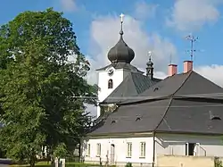
 Church of Saint Nicholas | |
 Flag  Coat of arms | |
 Nížkov Location in the Czech Republic | |
| Coordinates: 49°31′57″N 15°48′21″E | |
| Country | |
| Region | Vysočina |
| District | Žďár nad Sázavou |
| First mentioned | 1234 |
| Area | |
| • Total | 18.33 km2 (7.08 sq mi) |
| Elevation | 527 m (1,729 ft) |
| Population (2023-01-01)[1] | |
| • Total | 972 |
| • Density | 53/km2 (140/sq mi) |
| Time zone | UTC+1 (CET) |
| • Summer (DST) | UTC+2 (CEST) |
| Postal code | 592 12 |
| Website | www |
Administrative parts
Villages of Buková and Špinov are administrative parts of Nížkov.
Etyomology
The village was originally called Mníškov (from the Czech word mnich, i.e. "monk"), but due to complicated pronunciation, the name was distorted to Nížkov.[2]
Geography
Nížkov is located about 10 kilometres (6 mi) west of Žďár nad Sázavou and 21 km (13 mi) northeast of Jihlava. It lies mostly in the Upper Sázava Hills. A small part of the municipal territory in the southeast extends into the Křižanov Highlands and includes the highest point of Nížkov at 615 m (2,018 ft) above sea level. The Poděšínský Stream flows through the municipality.
History
The first written mention of Nížkov is from 1234, when there was founded a monastery with a wooden church by the monks from Osek.[2]
Sights
The main landmark of Nížkov is the Church of Saint Nicholas. It is an early Gothic church from the second half of the 13th century. In 1753, the Baroque nave was added and the tower was raised. The ossuary from 1709 stands in front of the west façade of the church.[2][3]
References
- "Population of Municipalities – 1 January 2023". Czech Statistical Office. 2023-05-23.
- "Historie obce" (in Czech). Obec Nížkov. Retrieved 2023-09-20.
- "Kostel sv. Mikuláše s kostnicí a křížem" (in Czech). National Heritage Institute. Retrieved 2023-09-21.