Muhu Parish
Muhu Parish (Estonian: Muhu vald) is a rural municipality of Estonia, in Saare County.[1] It has a population of 1876 (as of 1 January 2019) and an area of 208 km2 (80 sq mi).[2]
Muhu Parish
Estonian: Muhu vald | |
|---|---|
 | |
 Flag  Coat of arms | |
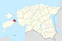 Muhu Parish within Saare County | |
| Country | |
| County | |
| Administrative Centre | Liiva |
| Area | |
| • Total | 208 km2 (80 sq mi) |
| Population (2019.01.01) | |
| • Total | 1,876 |
| • Density | 9.0/km2 (23/sq mi) |
| ISO 3166 code | EE-478 |
Geography
Muhu Parish is located on Muhu or Muhumaa and its neighbouring smaller islands of Kesselaid, Viirelaid, Võilaid and Suurlaid. It is located in the West Estonian archipelago and part of Saare County in the northeast of it. The main island, Muhu, is the third-largest island under the jurisdiction of Estonia. It touches the Baltic Sea. Muhu Parish is separated from mainland Estonia by the Suur Strait (Moonsund) and Saaremaa island by the Väike Strait.
Religion
Settlements
There are 52 villages (küla) in Muhu Parish. The villages are: Aljava, Hellamaa, Igaküla, Kallaste, Kantsi, Kapi, Kesse, Koguva, Kuviastu, Külasema, Laheküla, Lalli, Leeskopa, Lehtmetsa, Lepiku, Levalõpme, Liiva, Linnuse, Lõetsa, Mäla, Mõega, Mõisaküla, Nautse, Nõmmküla, Nurme, Oina, Pädaste, Päelda, Paenase, Pallasmaa, Pärase, Piiri, Põitse, Raegma, Rannaküla, Rässa, Raugi, Rebaski, Ridasi, Rinsi, Rootsivere, Simiste, Soonda, Suuremõisa, Tamse, Tupenurme, Tusti, Vahtraste, Vanamõisa, Viira, Võiküla, Võlla.
Gallery
- Northern coast of Muhu
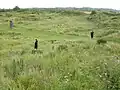 Muhu Stronghold
References
- "Päring kohanimeandmebaasist. Eesti kohanimed". www.eki.ee (in Estonian). Retrieved 6 July 2020.
- "Maakatastri statistika". Maa-amet (in Estonian). Retrieved 6 July 2020.
| Rural municipality | ||
|---|---|---|