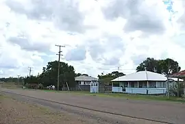
Didcot, Queensland
Didcot is a rural locality in the North Burnett Region, Queensland, Australia.[2] In the 2016 census Didcot had a population of 60 people.[1]
| Didcot Queensland | |||||||||||||||
|---|---|---|---|---|---|---|---|---|---|---|---|---|---|---|---|
 Didcot, 2008 | |||||||||||||||
 Didcot | |||||||||||||||
| Coordinates | 25.4677°S 151.8636°E | ||||||||||||||
| Population | 60 (2016 census)[1] | ||||||||||||||
| • Density | 0.48/km2 (1.23/sq mi) | ||||||||||||||
| Postcode(s) | 4621 | ||||||||||||||
| Area | 126.0 km2 (48.6 sq mi) | ||||||||||||||
| Time zone | AEST (UTC+10:00) | ||||||||||||||
| Location |
| ||||||||||||||
| LGA(s) | North Burnett Region | ||||||||||||||
| State electorate(s) | Callide | ||||||||||||||
| Federal division(s) | Flynn | ||||||||||||||
| |||||||||||||||
Geography
The now-closed Mungar-Monto railway line passed through Didcot from west to east with two now-abandoned railway stations serving the locality:
- Didcot railway station in the west of the locality (25.4745°S 151.8682°E) [3][4]
- Chowey railway station in the east of the locality (25.4648°S 151.9372°E).[3][5]
Didcot has the following mountains:
- Mount Melville (25.4359°S 151.9318°E) 160 metres (520 ft)[6][7]
- Mount Shamrock (25.4335°S 151.9254°E) 135 metres (443 ft)[6][8]
Mount Shamrock is a former mining town in the north-east of the locality (25.4381°S 151.9252°E), immediately south of the mountain of the same name.[9][10]
History
A report by R. W. Winks of the Department of Agriculture, Brisbane, surveying for the proposed Degilbo to Gayndah railway line extension, dated 10 November 1897 stated:- "After arranging for a horse, I proceeded to what is known as Irwin's Hotel, an accommodation-house on Didcot Creek, about 9 miles (14 km) from Woowoonga."[11] Degilbo at that time was known as Woowoonga.
Mount Shamrock Provisional School opened on 24 February 1890, closing circa 1894. The school reopened on 7 April 1896 as Mount Shamrock Provisional School. On 1 January 1909, it became Mount Shamrock State School. It closed circa 1935.[12]
Didcot Provisional School opened on 23 November 1908. On 1 January 1909, it became Didcot State School. It closed in 1967.[12]
In the 2011 census, Didcot had a population of 287 people.[13]
In the 2016 census Didcot had a population of 60 people.[1]
Heritage listings
_Bridge_(1994).jpg.webp)
Didcot has a number of heritage-listed sites, including:
- Chowey Cemetery Road, off Gooroolba Biggenden Road: Chowey Cemetery (also known as Mount Shamrock Cemetery)[14]
- on the Mungar-Monto railway line: Deep Creek Railway Bridge[14][15]
Engineers Australia listed on their Official Register of Engineering Heritage Markers:
- Degilbo-Mundubbera Railway Bridges in October 2016. A total of 12 bridges that are situated on the Mungar Junction to Monto railway line, including the Deep Creek Railway Bridge, are recognized with one Engineering Heritage Marker representing the "best example of a collection of historic railway bridges in Australia".[16][17]
Economy
There are a number of homesteads in the locality:[18]
- Avalon (25.4687°S 151.8334°E)
- Bibaringa (25.5004°S 151.8552°E)
- Brahman Pk (25.5687°S 151.8935°E)
- Danebo (25.5043°S 151.8739°E)
- Nora Creina (25.4624°S 151.8795°E)
- Plum Tree (25.4645°S 151.8919°E)
- Warra Creek (25.4993°S 151.8519°E)
Education
There are no schools in Didcot. The nearest primary schools are Coalstoun Lakes State School in neighbouring Coalstoun Lakes to the south and Biggenden State School in neighbouring Biggenden to the south-east. The nearest secondary schools are Biggenden State School (to Year 10) and Burnett State College (to Year 12) in Gayndah to the south-west.[19]
References
- Australian Bureau of Statistics (27 June 2017). "Didcot (SSC)". 2016 Census QuickStats. Retrieved 20 October 2018.
- "Didcot – locality in North Burnett Region (entry 45342)". Queensland Place Names. Queensland Government. Retrieved 28 December 2020.
- "Railway stations and sidings - Queensland". Queensland Open Data. Queensland Government. 2 October 2020. Archived from the original on 5 October 2020. Retrieved 5 October 2020.
- "Didcot – railway station in North Burnett Region (entry 9921)". Queensland Place Names. Queensland Government. Retrieved 28 September 2017.
- "Chowey – railway station in North Burnett Region (entry 7167)". Queensland Place Names. Queensland Government. Retrieved 28 September 2017.
- "Mountain peaks and capes - Queensland". Queensland Open Data. Queensland Government. 12 November 2020. Archived from the original on 25 November 2020. Retrieved 25 November 2020.
- "Mount Melville – mountain in North Burnett Region (entry 21578)". Queensland Place Names. Queensland Government. Retrieved 25 November 2020.
- "Mount Shamrock – mountain in North Burnett Region (entry 30561)". Queensland Place Names. Queensland Government. Retrieved 25 November 2020.
- "Mount Shamrock – locality unbounded in North Burnett Regional (entry 41999)". Queensland Place Names. Queensland Government. Retrieved 7 March 2022.
- "Geological sketch map Mount Shamrock, 1901". Queensland Historical Atlas (Map). University of Queensland. Archived from the original on 28 March 2022. Retrieved 25 July 2022.
- "REPORT BY R. W. WINKS". Maryborough Chronicle, Wide Bay and Burnett Advertiser. No. 7, 824. Queensland, Australia. 2 December 1897. p. 3. Retrieved 11 October 2022 – via National Library of Australia.
- Queensland Family History Society (2010), Queensland schools past and present (Version 1.01 ed.), Queensland Family History Society, ISBN 978-1-921171-26-0
- Australian Bureau of Statistics (31 October 2012). "Didcot (SSC)". 2011 Census QuickStats. Retrieved 19 August 2016.
- "North Burnett Local Heritage Register" (PDF). North Burnett Regional Council. Archived (PDF) from the original on 16 August 2019. Retrieved 16 August 2019.
- "Deep Creek Railway Bridge, Chowey (entry 600031)". Queensland Heritage Register. Queensland Heritage Council. Retrieved 12 July 2013.
- McLachlan, Mark (6 June 2018). "Degilbo to Mundubbera Railway Bridges, 1905 to 1914". Boyne Burnett Inland Rail Trail Blog. Retrieved 25 September 2022.
- McGrath, PSM, B. L.; Churchward, Alan (October 2015). "Nomination of the Gayndah Rail Bridges, Queensland for ENGINEERING HERITAGE RECOGNITION under Engineering Heritage Australia's Engineering Heritage Recognition Program" (PDF). Engineers Australia. pp. 1, 4, 7, 11, 14. Retrieved 26 September 2022.
- "Homesteads - Queensland". Queensland Open Data. Queensland Government. 18 November 2020. Archived from the original on 24 November 2020. Retrieved 24 November 2020.
- "Queensland Globe". State of Queensland. Retrieved 5 February 2021.
External links
![]() Media related to Didcot, Queensland at Wikimedia Commons
Media related to Didcot, Queensland at Wikimedia Commons