Mount Jumullong Manglo
Mount Jumullong Manglo (sometimes shortened to Mount Jumullong) is a peak in the south-west of the island of the United States territory of Guam.
| Mount Jumullong Manglo | |
|---|---|
 | |
| Highest point | |
| Elevation | 391 m (1,283 ft)[1] |
| Coordinates | 13°19′41″N 144°40′12″E[2] |
| Geography | |
 Mount Jumullong Manglo | |
| Topo map | USGS Agat |
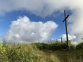
View of the peak
Rising to 391 meters (1,283 ft) above sea level, it is the 2nd highest[3] peak in Guam (after Mount Lamlam, and before Mount Bolanos).
Nearby is located the village of Agat (6.1 km or 3.8 mi[1]).
References
- Bendure, G. & Friary, N. (1988) Micronesia:A travel survival kit. South Yarra, VIC: Lonely Planet.
This article is issued from Wikipedia. The text is licensed under Creative Commons - Attribution - Sharealike. Additional terms may apply for the media files.