Mortana, South Australia
Mortana is a rural locality in South Australia, located on the Eyre Peninsula. It is traversed by the Flinders Highway.[7] The boundaries for the locality were established in April 2001 in respect of the long established local name.[8]
| Mortana South Australia | |||||||||||||||
|---|---|---|---|---|---|---|---|---|---|---|---|---|---|---|---|
 | |||||||||||||||
 Mortana | |||||||||||||||
| Coordinates | 33°01′41″S 134°27′11″E[1] | ||||||||||||||
| Population | 23 (SAL 2021)[2] | ||||||||||||||
| Established | 12 April 2001[3] | ||||||||||||||
| Postcode(s) | 5671[1] | ||||||||||||||
| Time zone | ACST (UTC+9:30) | ||||||||||||||
| • Summer (DST) | ACST (UTC+10:30) | ||||||||||||||
| LGA(s) | District Council of Streaky Bay[1] | ||||||||||||||
| Region | Eyre Western[1] | ||||||||||||||
| County | Robinson[1] | ||||||||||||||
| State electorate(s) | Flinders[4] | ||||||||||||||
| Federal division(s) | Grey[5] | ||||||||||||||
| |||||||||||||||
| |||||||||||||||
| Footnotes | Adjoining localities[1] | ||||||||||||||
Mortana Post Office opened on 2 February 1900 and closed on 31 March 1971.[9] A cricket club once existed there, having been founded in 1912; it also formerly had a school.[10] A railway line to the area was mooted in the 1920s, but did not occur.[11]
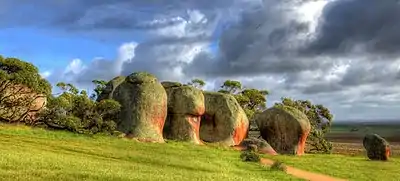
The Murphy's Haystacks geological formation is located at Mortana, and forms a local tourist attraction.[12][13]
The 2016 Australian census which was conducted in August 2016 reports that Mortana had a population of 16 people.[14]
Mortana is located within the federal division of Grey, the state electoral district of Flinders and the local government area of the District Council of Streaky Bay.[5][4][1]
References
- "Search results for 'Mortana, LOCB' with the following datasets being selected – 'NPW and Conservation Properties'. 'Suburbs and Localities', 'Counties', 'Local Government Areas','Postcodes', 'SA Government Regions', 'Gazetteer' and 'Roads'". Location SA Map Viewer. Government of South Australia. Retrieved 5 June 2018.
- Australian Bureau of Statistics (28 June 2022). "Mortana (Suburb and Locality)". Australian Census 2021 QuickStats. Retrieved 28 June 2022.
- Lawson, Robert (12 April 2001). "GEOGRAPHICAL NAMES ACT 1991 Notice to Assign Names and Boundaries to Places (in the District Council of Streaky Bay)" (PDF). The South Australian Government Gazette. South Australian Government. p. 1587. Retrieved 29 May 2018.
- "District of Flinders". Electoral Commission SA. Retrieved 29 May 2018.
- "Federal electoral division of Grey". Australian Electoral Commission. Retrieved 29 May 2018.
- "Monthly climate statistics: Summary statistics STREAKY BAY (nearest weather station)". Commonwealth of Australia , Bureau of Meteorology. Retrieved 29 May 2018.
- "Mortana SA 5671". Google Maps. Retrieved 13 February 2016.
- "Search result for "Mortana (LOCB)"". Department of Planning Transport and Infrastructure. Archived from the original on 12 October 2016. Retrieved 26 September 2015.
- "Mortana". Post Office Finder. Premier Postal. Retrieved 14 February 2016.
- "MORTANA". West Coast Sentinel. Streaky Bay, SA. 20 September 1912. p. 2. Retrieved 14 February 2016 – via National Library of Australia.
- "A WEST COAST RAILWAY". The Chronicle. Adelaide. 27 November 1926. p. 44. Retrieved 14 February 2016 – via National Library of Australia.
- "Murphy's Haystacks, SA". Australian Traveller. Retrieved 14 February 2016.
- "Murphy's Haystacks". Lonely Planet. Retrieved 14 February 2016.
- Australian Bureau of Statistics (27 June 2017). "Mortana". 2016 Census QuickStats. Retrieved 5 June 2018.