Morsemere, New Jersey
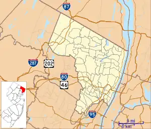
Morsemere is a neighborhood in Bergen County, in the U.S. state of New Jersey, largely in the northern part of Ridgefield and straddling the border of Palisades Park south of start of U.S. Route 46.[4][5][6][7][8][9]
Morsemere, New Jersey | |
|---|---|
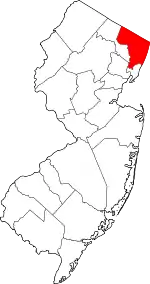
 Morsemere, New Jersey Location of Morsemere in Bergen County Inset: Location of county within the state of New Jersey  Morsemere, New Jersey Morsemere, New Jersey (New Jersey)  Morsemere, New Jersey Morsemere, New Jersey (the United States) | |
| Coordinates: 40°50′34″N 74°00′17″W | |
| Country | |
| State | |
| County | Bergen |
| Borough | Palisades Park and Ridgefield |
| Elevation | 33 ft (10 m) |
| Time zone | UTC−05:00 (Eastern (EST)) |
| • Summer (DST) | UTC−04:00 (EDT) |
| GNIS feature ID | 878502[1] |
Morsemere | |||||||||||
|---|---|---|---|---|---|---|---|---|---|---|---|
 | |||||||||||
| General information | |||||||||||
| Location | Ridgefield, New Jersey | ||||||||||
| Owned by | Northern Railroad of New Jersey (1859–1942) Erie Railroad (1942–1960) Erie Lackawanna Railway (1960–1976) | ||||||||||
| Line(s) | Erie Railroad Northern Branch | ||||||||||
| Construction | |||||||||||
| Platform levels | 1 | ||||||||||
| Other information | |||||||||||
| Station code | 1913[2] | ||||||||||
| History | |||||||||||
| Opened | 1870s | ||||||||||
| Closed | September 30, 1966[3] | ||||||||||
| Rebuilt | 1872 | ||||||||||
| Former services | |||||||||||
| |||||||||||
History
Morsemere is named for Samuel Morse,[5] who had bought property with the intention of building a home there, but died before doing so. His estate was subdivided[10] and laid out from 1899 to 1902.[11] It underwent massive expansion around 1910.[12][13]
The eponymous Morsemere Church was completed in 1928.[7][14] The locally founded Morsemere Trust Company was eventually subsumed by MetroCorp Bancshares.
Until the 1950s when dial telephone service arrived, the local exchange was MOrsemere 6.
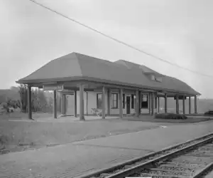
The Erie Railroad Northern Branch had a station in the neighborhood as well as at Ridgefield.[10][15] The station house, built when the community was developed, burn down in 1928.[16] It was also accessible by trolley form the 130th Ferry Terminal in Edgewater.[17]
See also
References
- "Morsemere". Geographic Names Information System. United States Geological Survey, United States Department of the Interior.
- "List of Station Names and Numbers". Jersey City, New Jersey: Erie Railroad. May 1, 1916. Retrieved January 14, 2011.
- O'Donnell, Maureen (October 1, 1966). "Erie's 1205 Goes for Last Trip". The Bergen Evening Record. Hackensack, New Jersey. pp. A1–A2. Retrieved December 29, 2018 – via Newspapers.com.

- Morsemere in Ridgefield, New Jersey (Map). May 25, 1940. doi:10.7282/T3VM4CX7 – via rucore.libraries.rutgers.edu.
Map of the Morsemere section of Ridgefield, Bergen County, N.J. with insets of Palisades Park, Ridgefield and Teaneck, showing properties for sale at public auction by the State of New York Banking Department.
- Santis, Mauro De (May 25, 2017). Ridgefield. Arcadia Publishing. ISBN 9781467126571.
- Beck, George M. Jr. (May 2009). Palisades Park. Arcadia Publishing. ISBN 9780738565439.
- Maehrlein, Lauren (2016). "Morsemere Community Church: A Brief History" (PDF).
Morsemere was never an incorporated entity, but is a neighborhood that straddles the northern border of Ridgefield and the southern border of Palisades Park.
- Google (March 7, 2015). "Morsemere, New Jersey" (Map). Google Maps. Google. Retrieved March 7, 2015.
- Federal Writers' Project (October 31, 2013). The WPA Guide to New Jersey: The Garden State. Trinity University Press. ISBN 9781595342287.
- "History of Ridgefield - Ridgefield, New Jersey". www.ridgefieldnj.gov.
Among the noted people who owned property in the new borough was Samuel F. B. Morse. He owned property running from Morse Avenue east to Dallytown Road (Bergen Boulevard). Morse bought the property with the intention of building a home here. A barn was the only structure completed when the inventor died in 1872. The barn was later converted into a house on Morse Avenue. The Morse Estate was subdivided into 66 lots at 25-feet wide, plus about 72 lots of over 50-feet and a strip of smaller lots on the northside of development, running east and west, and sold. This venture proved extremely successful and paved the way for future real estate speculation and development.
- "Northern Branch Corridor DEIS" (PDF). NJ Transit. December 2011. Retrieved May 25, 2021.
Samuel F. B. Morse, the inventor, lived in Ridgefield, and by 1891 a sub-development was planned on the Morse Estate between Edgewater Avenue and Clark Avenue, east of Morse Avenue. Between 1899 and 1902, the streets of Morsemere Park had been built in the northern section of the borough. This development, which had its own railroad depot, was named in honor of Samuel F. B. Morse, inventor of the telegraph and the Morse code.
- "Rapid Development at Morsemere". timesmachine.nytimes.com.
- "Development at Morsemere". timesmachine.nytimes.com.
- "To Lay Stone at Morsemere Today".
- Catlin, George L. (1872), Suburban Homes for City Business Men: A Description of the Country Adjacent to the Eastern Division and Branches of the Erie Railway and Northern Railroad of New Jersey, Erie Railway
- "Morsemere Station Burns". timesmachine.nytimes.com.
- "Homes on the Palisades", The New York Times, September 4, 1910. Accessed August 22, 2023. "The section of the Palisades immediately at the other side of the 130th Street ferry is really the gateway of a vast area which in a very short time is bound to develop into a sort of metropolitan annex. with Edgewater at the foot of the cliffs, Grantwood at the summit, and Morsemere on the western slope."
