Mopa-Muro
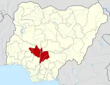
Mopa-Muro is a Local Government Area in Kogi State, Nigeria. Its headquarters are in the town of Mopa on the A123 highway.
Mopa-Amuro | |
|---|---|
 Mopa-Amuro Location in Nigeria | |
| Coordinates: 8°05′50″N 5°53′45″E | |
| Country | |
| State | Kogi State |
| Area | |
| • Total | 901 km2 (348 sq mi) |
| Population (2006 census) | |
| • Total | 44,037 |
| Time zone | UTC+1 (WAT) |
| 3-digit postal code prefix | 261 |
| ISO 3166 code | NG.KO.MM |
It has an area of 901 km2 (348 sq mi) and a population of 44,037 at the 2006 census.[1]
The postal code of the area is 261.
Geography
The Mopa Moro Local Government Area has an average temperature of 28 degrees Celsius and a total area of 901 square kilometres. The Local Government Area experiences two distinct seasons: the dry season and the rainy season. The average humidity level in the local government area is 65 percent.[1]
Economy
Mopa Moro Local Government Area has a variety of mineral reserves, including mica, talc, and limestone. Along with its rich agricultural history, the Local Government Area is well-known for producing a variety of crops, including vegetables, melon, cassava, and yam. Mopa Moro Local Government Area experiences a growth in trade due to the presence of multiple markets that facilitate the interchange of a wide range of goods and services.[3]
Business information
References
- HASC, population, area and Headquarters Statoids
- "Post Offices- with map of LGA". NIPOST. Archived from the original on 2009-10-07. Retrieved 2009-10-20.
- "Mopa-Muro Local Government Area". www.manpower.com.ng. Retrieved 2023-10-26.
- "Mopa-Muro Local Government Area". www.finelib.com. Retrieved 2023-10-26.
