Mayo, Florida
Mayo, Florida is a town and the only municipality in Lafayette County, Florida, United States. The population was 1,237 at the 2010 census. It is the county seat of Lafayette County.[4] In August 2018, Mayo temporarily changed its name to Miracle Whip as an advertising stunt with Kraft's Miracle Whip brand.[5]
Mayo, Florida | |
|---|---|
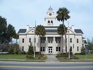 Lafayette County Courthouse | |
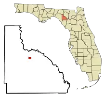 Location in Lafayette County and the state of Florida | |
| Coordinates: 30°3′7″N 83°10′32″W | |
| Country | |
| State | |
| County | Lafayette |
| Government | |
| • Bruno Eddel (R) | Mayor |
| Area | |
| • Total | 0.90 sq mi (2.33 km2) |
| • Land | 0.90 sq mi (2.33 km2) |
| • Water | 0.00 sq mi (0.00 km2) |
| Elevation | 89 ft (27 m) |
| Population (2020) | |
| • Total | 1,055 |
| • Density | 1,173.53/sq mi (453.08/km2) |
| Time zone | UTC-5 (Eastern (EST)) |
| • Summer (DST) | UTC-4 (EDT) |
| ZIP code | 32066 |
| Area code | 386 |
| FIPS code | 12-43575[2] |
| GNIS feature ID | 0286548[3] |
Geography
Mayo is located at 30°03′07″N 83°10′32″W.[6]
According to the United States Census Bureau, the town has a total area of 2.1 km2 (0.81 sq mi), all land.
Climate
| Climate data for Mayo, Florida, 1991–2020 normals, extremes 1949–present | |||||||||||||
|---|---|---|---|---|---|---|---|---|---|---|---|---|---|
| Month | Jan | Feb | Mar | Apr | May | Jun | Jul | Aug | Sep | Oct | Nov | Dec | Year |
| Record high °F (°C) | 88 (31) |
93 (34) |
92 (33) |
96 (36) |
101 (38) |
104 (40) |
103 (39) |
103 (39) |
99 (37) |
96 (36) |
92 (33) |
88 (31) |
104 (40) |
| Mean maximum °F (°C) | 80.3 (26.8) |
82.7 (28.2) |
85.8 (29.9) |
89.4 (31.9) |
94.5 (34.7) |
97.1 (36.2) |
97.6 (36.4) |
96.8 (36.0) |
94.9 (34.9) |
90.6 (32.6) |
85.9 (29.9) |
81.8 (27.7) |
98.7 (37.1) |
| Average high °F (°C) | 67.7 (19.8) |
72.0 (22.2) |
77.7 (25.4) |
81.6 (27.6) |
87.8 (31.0) |
90.9 (32.7) |
91.8 (33.2) |
91.6 (33.1) |
88.8 (31.6) |
83.1 (28.4) |
76.9 (24.9) |
71.0 (21.7) |
81.7 (27.6) |
| Daily mean °F (°C) | 54.5 (12.5) |
58.2 (14.6) |
63.5 (17.5) |
67.5 (19.7) |
74.7 (23.7) |
79.9 (26.6) |
81.6 (27.6) |
81.5 (27.5) |
78.2 (25.7) |
70.3 (21.3) |
63.0 (17.2) |
57.4 (14.1) |
69.2 (20.7) |
| Average low °F (°C) | 41.3 (5.2) |
44.4 (6.9) |
49.4 (9.7) |
53.3 (11.8) |
61.6 (16.4) |
68.9 (20.5) |
71.4 (21.9) |
71.4 (21.9) |
67.7 (19.8) |
57.6 (14.2) |
49.1 (9.5) |
43.8 (6.6) |
56.7 (13.7) |
| Mean minimum °F (°C) | 22.2 (−5.4) |
25.3 (−3.7) |
29.9 (−1.2) |
39.2 (4.0) |
48.4 (9.1) |
60.6 (15.9) |
66.0 (18.9) |
66.2 (19.0) |
58.4 (14.7) |
40.5 (4.7) |
29.8 (−1.2) |
25.7 (−3.5) |
20.4 (−6.4) |
| Record low °F (°C) | 7 (−14) |
12 (−11) |
19 (−7) |
31 (−1) |
41 (5) |
47 (8) |
58 (14) |
58 (14) |
40 (4) |
27 (−3) |
19 (−7) |
10 (−12) |
7 (−14) |
| Average precipitation inches (mm) | 4.66 (118) |
3.40 (86) |
4.24 (108) |
3.09 (78) |
3.11 (79) |
7.58 (193) |
7.56 (192) |
8.11 (206) |
5.39 (137) |
3.07 (78) |
2.04 (52) |
3.33 (85) |
55.58 (1,412) |
| Average precipitation days (≥ 0.01 in) | 8.3 | 7.8 | 7.4 | 6.1 | 6.6 | 13.7 | 13.8 | 15.5 | 9.9 | 5.9 | 5.4 | 7.6 | 108.0 |
| Source: NOAA[7][8] | |||||||||||||
Demographics
| Census | Pop. | Note | %± |
|---|---|---|---|
| 1910 | 578 | — | |
| 1920 | 531 | −8.1% | |
| 1930 | 555 | 4.5% | |
| 1940 | 915 | 64.9% | |
| 1950 | 679 | −25.8% | |
| 1960 | 687 | 1.2% | |
| 1970 | 793 | 15.4% | |
| 1980 | 891 | 12.4% | |
| 1990 | 917 | 2.9% | |
| 2000 | 988 | 7.7% | |
| 2010 | 1,237 | 25.2% | |
| 2020 | 1,055 | −14.7% | |
| U.S. Decennial Census[9] | |||
As of the census[2] of 2000, there were 988 people, 338 households, and 228 families residing in the town. The population density was 1,209.1 inhabitants per square mile (466.8/km2). There were 365 housing units at an average density of 446.7 per square mile (172.5/km2). The racial makeup of the town was 61.23% White, 27.43% African American, 0.40% Native American, 0.10% Pacific Islander, 9.62% from other races, and 1.21% from two or more races. Hispanic or Latino of any race were 16.80% of the population.
There were 338 households, out of which 33.1% had children under the age of 18 living with them, 42.3% were married couples living together, 19.2% had a female householder with no husband present, and 32.5% were non-families. 28.4% of all households were made up of individuals, and 13.3% had someone living alone who was 65 years of age or older. The average household size was 2.70 and the average family size was 3.23.
In the town, the population was spread out, with 28.2% under the age of 18, 11.1% from 18 to 24, 24.8% from 25 to 44, 21.7% from 45 to 64, and 14.2% who were 65 years of age or older. The median age was 33 years. For every 100 females, there were 96.0 males. For every 100 females age 18 and over, there were 92.1 males.
The median income for a household in the town was $25,398, and the median income for a family was $28,438. Males had a median income of $21,802 versus $17,697 for females. The per capita income for the town was $13,298. About 30.6% of families and 34.6% of the population were below the poverty line, including 42.5% of those under age 18 and 54.7% of those age 65 or over.
Historic buildings and structures
Historic buildings and structures in Mayo include:[10]
- The 1883 Old Lafayette County Courthouse, now a bed and breakfast;
- The 1888 Old Mayo Free Press Building, just south of the Old Courthouse;
- The 1908 Lafayette County Courthouse;
- The 1880s House of the Seven Gables and
- The 1915 M. Pico Building on the corner of Monroe and Main streets.
Notable people
- Kerwin Bell, former college and professional quarterback and collegiate coach
- Bill Birchfield, lawyer, Florida state representative and self-described, "Duke of Mayo"
- Reggie McGrew, former college and professional defensive line for University of Florida and The 49ers
- Herbert Perry, former football & baseball player University of Florida. Also MLB player with Indians, Rays, White Sox, and Rangers.
- Charles Strong, was lynched on January 17, 1922, in Mayo[11]
- Dan White, (March 25, 1908 – July 7, 1980), American actor in vaudeville, theater, radio, film and television
- Ricky Nattiel, former college and professional football player, Wide receiver, for the University of Florida and the Denver Broncos.
References
- "2020 U.S. Gazetteer Files". United States Census Bureau. Retrieved October 31, 2021.
- "U.S. Census website". United States Census Bureau. Retrieved January 31, 2008.
- "US Board on Geographic Names". United States Geological Survey. October 25, 2007. Retrieved January 31, 2008.
- "Find a County". National Association of Counties. Archived from the original on May 31, 2011. Retrieved June 7, 2011.
- Martinez, Gina (August 28, 2018). "Town Temporarily Changes Its Name to 'Miracle Whip' for a Totally Legitimate Reason". Time.
- "US Gazetteer files: 2010, 2000, and 1990". United States Census Bureau. February 12, 2011. Retrieved April 23, 2011.
- "NOWData - NOAA Online Weather Data". National Oceanic and Atmospheric Administration. Retrieved June 24, 2021.
- "Summary of Monthly Normals 1991-2020". National Oceanic and Atmospheric Administration. Retrieved June 24, 2021.
- "Census of Population and Housing". Census.gov. Retrieved June 4, 2015.
- A Guide to Florida's Historic Architecture, 1989, Gainesville: University of Florida Press, p. 47, ISBN 0-8130-0941-3
- The Pensacola Journal, January 18, 1922, p. 1.
- "Victim killed W.R. Taylor, son of a well known Naval Stores Operator last Saturday Night". The Pensacola Journal. Pensacola, Escambia, Florida: Mayes & Co. January 18, 1922. pp. 1–8. ISSN 1941-109X. OCLC 16280864. Retrieved January 29, 2022.
External links
- Mayo Free Press newspaper that serves Mayo, Florida is available in full-text with images in Florida Digital Newspaper Library
- Mayo, Florida heritage travel website with information about Mayo, Florida.
Municipalities and communities of Lafayette County, Florida, United States | ||
|---|---|---|
| Town | 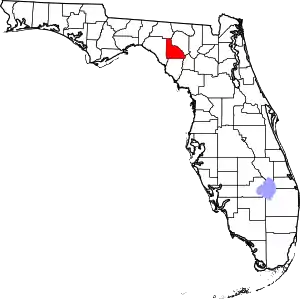 | |
| CDP | ||
| Unincorporated community | ||
| Ghost town | ||