Mayfield (Queanbeyan–Palerang)
Mayfield is a locality in the Queanbeyan–Palerang Regional Council, New South Wales, Australia. It is located about 85 km east of Canberra and 58 km south of Goulburn.[2][3] At the 2021 census, it had a population of 57.[1] It had an Anglican church, St Luke's from 1895 to 1965. A "half-time" school was located at Virginia station in Mayfield from 1894 to 1899.[4]
| Mayfield New South Wales | |||||||||||||||
|---|---|---|---|---|---|---|---|---|---|---|---|---|---|---|---|
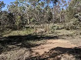 Site of St Luke's Church of England | |||||||||||||||
 Mayfield Location in New South Wales | |||||||||||||||
| Coordinates | 35°13′57″S 149°46′52″E | ||||||||||||||
| Population | 57 (2021 census)[1] | ||||||||||||||
| Postcode(s) | 2580 | ||||||||||||||
| Location | |||||||||||||||
| LGA(s) | Queanbeyan-Palerang Regional Council | ||||||||||||||
| Region | Southern Tablelands | ||||||||||||||
| County | Argyle | ||||||||||||||
| Parish | Boro | ||||||||||||||
| State electorate(s) | Monaro | ||||||||||||||
| Federal division(s) | Eden-Monaro | ||||||||||||||
| |||||||||||||||
Heritage listings
Mayfield has a number of heritage-listed sites, including:
References
- Australian Bureau of Statistics (28 June 2022). "Mayfield (Queanbeyan-Palerang Regional - NSW)". 2021 Census QuickStats. Retrieved 29 September 2022.
- "Mayfield". Geographical Names Register (GNR) of NSW. Geographical Names Board of New South Wales. Retrieved 14 February 2018.
- "Mayfield". OpenStreetMap. Retrieved 14 February 2018.
- "Virginia in the School history database search". New South Wales Department of Education. Retrieved 23 July 2018.
- "Virginia". New South Wales State Heritage Register. Department of Planning & Environment. H01374. Retrieved 18 May 2018.
 Text is licensed by State of New South Wales (Department of Planning and Environment) under CC-BY 4.0 licence.
This article is issued from Wikipedia. The text is licensed under Creative Commons - Attribution - Sharealike. Additional terms may apply for the media files.