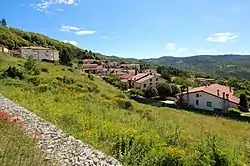
Marroneto
Marroneto is a village in Tuscany, central Italy, administratively a frazione of the comune of Santa Fiora, province of Grosseto, in the area of Mount Amiata.
Marroneto | |
|---|---|
 | |
 Marroneto Location of Marroneto in Italy | |
| Coordinates: 42°50′17″N 11°35′58″E | |
| Country | |
| Region | |
| Province | Grosseto (GR) |
| Comune | Santa Fiora |
| Elevation | 690 m (2,260 ft) |
| Demonym | Marronetai |
| Time zone | UTC+1 (CET) |
| • Summer (DST) | UTC+2 (CEST) |
| Postal code | 58037 |
| Dialing code | (+39) 0564 |
The village is named after the marroni (chestnuts).
Geography
Marroneto is about 65 km from Grosseto and 1 km from Santa Fiora. The village is so close to Santa Fiora that it is considered a peripheral neighbourhood of the town.[1] It is situated along the Provincial Road which links Santa Fiora to Bagnolo and Piancastagnaio.
Subdivisions
Marroneto is composed by eight hamlets: Case Baciacchi, Case Bigi, Case Raspini, Case Tonini, Gretini, Mormoraio, Renaiolo – the oldest one – and Soana.[1]
Traditions
The village is known for its well-preserved primitive traditions: the most important one is that of Carnevale Morto (Dead Carnival), an old ritual where Quaresima metaphorically kills Carnevale.[2][3]
Notes
- Niccolai, Lucio (2009). Santa Fiora. Invito alla scoperta del centro storico e del territorio. Arcidosso: Edizioni Effigi. pp. 87–89.
- Niccolai, pp. 105–107.
- (in Italian) Archivio delle tradizioni popolari della Maremma grossetana - Carnevale Morto Archived 2013-12-30 at the Wayback Machine
Bibliography
- Arezzini, Michele (2016). Santa Fiora e il suo territorio. Arcidosso: Edizioni Effigi. pp. 26–27.
- Niccolai, Lucio (2009). Santa Fiora. Invito alla scoperta del centro storico e del territorio. Arcidosso: Edizioni Effigi. pp. 87–89, 104–109.