Mallory Township, Clayton County, Iowa
Mallory Township is a township in Clayton County, Iowa, USA. At the 2010 census, its population was 395, down from 411 ten years earlier.
Mallory Township | |
|---|---|
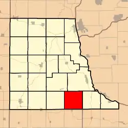 Location in Clayton County | |
| Coordinates: 42°41′31″N 091°11′26″W | |
| Country | |
| State | |
| County | Clayton |
| Area | |
| • Total | 35.98 sq mi (93.19 km2) |
| • Land | 35.98 sq mi (93.18 km2) |
| • Water | 0 sq mi (0.01 km2) 0.01% |
| Elevation | 1,181 ft (360 m) |
| Population (2010) | |
| • Total | 391 |
| • Density | 10.9/sq mi (4.2/km2) |
| GNIS feature ID | 0468336 |
Geography
Mallory Township covers an area of 35.98 square miles (93.2 km2) and contains one incorporated settlement, Osterdock. According to the USGS, it contains seven cemeteries: Bethel, Bolsinger, Brown, Hansel, King, Koenig and Noggle.
The streams of Joles Creek, Mill Creek and Peck Creek run through this township.
External links
Municipalities and communities of Clayton County, Iowa, United States | ||
|---|---|---|
| Cities | Map of Iowa highlighting Clayton County | |
| Townships | ||
| Unincorporated communities | ||
| Footnotes | ‡This populated place also has portions in an adjacent county or counties | |
This article is issued from Wikipedia. The text is licensed under Creative Commons - Attribution - Sharealike. Additional terms may apply for the media files.