Malartic, Quebec
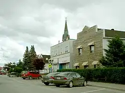
Malartic is a town on the Malartic River in northwestern Quebec, Canada, in the La Vallée-de-l'Or Regional County Municipality. It is located about 80 kilometres (50 mi) east of the centre of Rouyn-Noranda along Quebec Route 117 and the Canadian National Railway.
Malartic | |
|---|---|
 | |
| Motto(s): Ma ville, ma famille, ma fierté ("My town, my family, my pride") | |
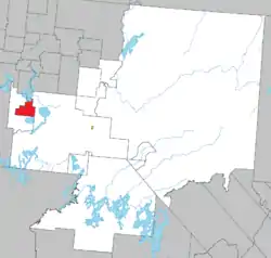 Location within La Vallée-de-l'Or RCM. | |
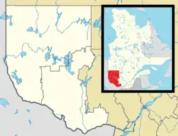 Malartic Location in western Quebec. | |
| Coordinates: 48°08′N 78°08′W[1] | |
| Country | |
| Province | |
| Region | Abitibi-Témiscamingue |
| RCM | La Vallée-de-l'Or |
| Settled | 1928 |
| Constituted | April 28, 1939 |
| Government | |
| • Mayor | Martin Ferron[3] |
| • Federal riding | Abitibi—Baie-James— Nunavik—Eeyou |
| • Prov. riding | Abitibi-Est |
| Area | |
| • Total | 157.00 km2 (60.62 sq mi) |
| • Land | 148.68 km2 (57.41 sq mi) |
| Population (2011)[4] | |
| • Total | 3,449 |
| • Density | 23.2/km2 (60/sq mi) |
| • Pop 2006-2011 | |
| • Dwellings | 1,531 |
| Time zone | UTC−5 (EST) |
| • Summer (DST) | UTC−4 (EDT) |
| Postal code(s) | |
| Area code | 819 |
| Highways | |
| Website | www.ville. malartic.qc.ca |
_(17017391900).jpg.webp)
In addition to the main settlement of Malartic, the municipality also includes the smaller settlement of Norrie.
History
At the time when the Abitibi region was being surveyed and organized in 1907, the name Malartic was chosen for the geographic township and lake, following the pattern of assigning names of regiments and officers of General Montcalm's army.[5] It was named after Anne Joseph Hippolyte de Maurès, Comte de Malartic, aide de camp to Montcalm.[1]
The discovery of major gold deposits in 1923 led to a gold rush in the Abitibi region, attracting settlers (exclusively men during the first six years) to the area in 1928. In 1935, the Canadian Malartic Gold Mines began operation, employing people from all over the province, Canada, and several east European countries. Together with Eastern Malartic and Malartic Goldfields that began operating in 1937 and 1939 respectively, these three became Quebec's largest gold mines. But newly arriving workers were not permitted to settle near the mines and would build a squatter camp on Crown land about 4 km (2+1⁄2 miles) north of Malartic, that became the community of Roc d'Or. The two settlements grew concurrently, duplicating services. But the parishes (Saint-Martin-de-Tours in 1928), railway station, and post office (1936) were established near the mines in Malartic.[1][6][7]
In 1939, the Town of Malartic was incorporated under the auspices of the Quebec Ministry of Mines, in an attempt to halt the proliferation of squatter camps in the Abitibi region. In 1943, the entire community of Roc d'Or was ordered to move to Malartic by the provincial government and the settlement was demolished. Despite a mining accident in April 1947 that killed 12 miners in an underground fire, Malartic was thriving throughout the 1950s, reaching a peak of nearly 7000 residents.[6][7]
But in 1965, Canadian Malartic and Malartic Goldfields closed their mines, followed by the Barnat and East Malartic mines in the 1980s. This led to rapid decline in the economy and population.[6][7]
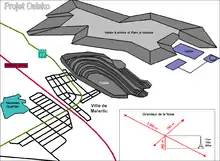
In 2008 and 2009, renewed exploration by Osisko Mining revealed an untapped new gold deposit, estimated at 9 million ounces, beneath the town. The company received approval from the government of Quebec to launch what would become Canada's largest ever open pit gold mine.[8] The project, which will have an estimated cost of $1 billion if approved, would see most of the portion of the town lying south of Route 117, consisting of about 200 houses and several of the town's public facilities, relocated to a new housing development in the north end of town.[8] This move was featured in season 4 of the television show Monster Moves. As of late 2009, most of the relocation work had been completed, and this, before the end of public consultations by Quebec's Ministry of Sustainable Development, Environment and Parks.[9]
Government
As of January 2011, the municipal government consists of mayor André Vezeau and councillors Jude Boucher, Sylvie Daigle, Martin Ferron, Daniel Magnan, Guy Morrissette, and Jean Turgeon.[2]
Federally, Malartic is located in the electoral district of Abitibi—Baie-James—Nunavik—Eeyou, currently represented in the House of Commons of Canada by Sylvie Bérubé of the Bloc Québécois. Provincially, it is in the district of Abitibi-Est, represented in the National Assembly of Quebec by Pierre Dufour of the Coalition Avenir Québec.
Demographics
In the 2021 Census of Population conducted by Statistics Canada, Malartic had a population of 3,355 living in 1,481 of its 1,635 total private dwellings, a change of -0.7% from its 2016 population of 3,377. With a land area of 147.45 km2 (56.93 sq mi), it had a population density of 22.8/km2 (58.9/sq mi) in 2021.[10][11]
Mother tongue:[12]
- English as first language: 4.2%
- French as first language: 90.3%
- English and French as first language: 0.6%
- Other as first language: 4.9%
Notable people
- Yves Bergeron, ice hockey winger
- Michel Brière, ice hockey centre
- Marcel Côté, economist and politician
- Robbie King, organist
- Jim Watson, ice hockey defenseman
Education
- École Des Explorateurs – Kindergarten to grade six
- École Secondaire Le Tremplin – secondary grades one to five
- Trait d'Union – adult education
References
- "Malartic (ville)" (in French). Commission de toponymie du Québec. Retrieved 2011-01-13.
- "Malartic". Répertoire des municipalités (in French). Ministère des Affaires municipales, des Régions et de l'Occupation du territoire. Archived from the original on 2012-06-05. Retrieved 2011-01-13.
- "Ville de Malartic » Membres du conseil". Archived from the original on 2019-07-16. Retrieved 2019-07-16.
- "Malartic census profile". 2011 Census data. Statistics Canada. Retrieved 2011-01-13.
- "Lac Malartic" (in French). Commission de toponymie du Québec. Retrieved 2011-01-13.
- Gourd, Benoit-Beaudry. "Malartic", in The Canadian Encyclopedia (Edmonton: Hurtig Publishing, 1988), Volume 2, p.1287.
- "Histoire et cartes" (in French). Ville de Malartic. Archived from the original on 2010-12-26. Retrieved 2011-01-13.
- Rhéal Séguin, "Tiny Quebec town is sitting on a gold mine". The Globe and Mail, July 14, 2009.
- Osisko Mines website
- "Population and dwelling counts: Canada, provinces and territories, and census subdivisions (municipalities), Quebec". Statistics Canada. February 9, 2022. Retrieved August 29, 2022.
- Statistics Canada: 1996, 2001, 2006, 2011 census
- "Malartic community profile". 2006 Census data. Statistics Canada. 13 March 2007. Retrieved 2011-01-13.
External links
- (in French) Ville de Malartic
Adjacent Municipal Subdivisions | ||||||||||||||||
|---|---|---|---|---|---|---|---|---|---|---|---|---|---|---|---|---|
| ||||||||||||||||
| Cities | |
|---|---|
| Municipalities | |
| Parishes | |
| Unorganized territories | |
| |