Mahoba
Mahoba is a city in Mahoba District of the Indian state of Uttar Pradesh[3] in the Bundelkhand region, well known for the ninth century granite Sun temple built in Pratihara style. It is also well known for the 24 rock-cut Jain tirthankara image on Gokhar hill.[4] Mahoba is known for its closeness to Khajuraho, Lavkushnagar and other historic places like Kulpahar, Charkhari, Kalinjar, Orchha, and Jhansi. The town is connected with railways and state highways.
Mahoba | |
|---|---|
City | |
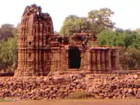 Sun temple, Mahoba | |
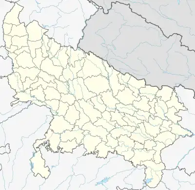 Mahoba Location in Uttar Pradesh, India  Mahoba Mahoba (India) | |
| Coordinates: 25.28°N 79.872885°E | |
| Country | |
| State | Uttar Pradesh |
| District | Mahoba |
| Government | |
| • District Magistrate & Collector | Manoj Kumar Chauhan |
| Elevation | 214 m (702 ft) |
| Population (2011) | |
| • Total | 95,216 |
| Language | |
| • Official | Hindi[1] |
| • Additional official | Urdu[1] |
| Time zone | UTC+5:30 (IST) |
| PIN | 210 427 |
| Telephone code | 91-5281 |
| Vehicle registration | UP-95 |
| Sex ratio | 922 ♂/♀ |
| Literacy | 76.91%[2] |
| Website | www |
Geography
Topography
Mahoba is located at 25.28°N 79.87°E.[5] It has an average elevation of 214 metres (702 feet).
Climate
| Climate data for Mahoba, Uttar Pradesh | |||||||||||||
|---|---|---|---|---|---|---|---|---|---|---|---|---|---|
| Month | Jan | Feb | Mar | Apr | May | Jun | Jul | Aug | Sep | Oct | Nov | Dec | Year |
| Average high °C (°F) | 24 (75) |
28 (82) |
33 (91) |
39 (102) |
42 (108) |
39 (102) |
33 (91) |
32 (90) |
33 (91) |
33 (91) |
30 (86) |
36 (97) |
42 (108) |
| Daily mean °C (°F) | 16 (61) |
20 (68) |
25 (77) |
31 (88) |
35 (95) |
33 (91) |
29 (84) |
29 (84) |
29 (84) |
27 (81) |
22 (72) |
18 (64) |
28 (82) |
| Average low °C (°F) | 9 (48) |
13 (55) |
17 (63) |
23 (73) |
27 (81) |
28 (82) |
26 (79) |
25 (77) |
24 (75) |
20 (68) |
15 (59) |
10 (50) |
9 (48) |
| Average precipitation mm (inches) | 3.9 (0.15) |
10.9 (0.43) |
12.1 (0.48) |
7.6 (0.30) |
5.4 (0.21) |
69 (2.7) |
166.3 (6.55) |
184.5 (7.26) |
89.4 (3.52) |
37.2 (1.46) |
11.4 (0.45) |
3.7 (0.15) |
601.4 (23.68) |
| Average precipitation days | 1.8 | 1.5 | 1.4 | 1.1 | 1.4 | 3.3 | 8.8 | 9.4 | 4.1 | 1.2 | 0.6 | 0.9 | 35.5 |
| Source: Time and Date[6] | |||||||||||||
Demographics
As of 2011 India census, Mahoba has a population of 95,216 divided into 25 wards. Mahoba has an average literacy rate of 74.91%, higher than the state average of 67.68%: male literacy is 82.03%, and female literacy is 66.88% with 12.68% of the population is under 6 years of age.
Schedule Caste (SC) and Schedule Tribe (ST) constitutes 14.93% and 0.42% of the total population in Mahoba. Based on the census 75.21% of the total population are Hindus, 23.64% are Muslims and the rest is occupied by other faiths.[7]
Tourist destinations
Tourist destinations in and around Mahoba include:
- Rahila Sagar Sun Temple
- Kakramath Temple
- Gorakhgiri Hill
- Vijay Sagar Pakshi Vihar
- Rahila Sagar
- Madan Sagar
- Arjun Sagar Dam
- Senapati Mahal
- Raja ka Tal
Notable people
- Rani Durgavati, a Chandela princess of Mahoba
- Pushpendra Singh Chandel, MP, BJP
References
- "52nd Report of the Commissioner for Linguistic Minorities in India" (PDF). nclm.nic.in. Ministry of Minority Affairs. Archived from the original (PDF) on 25 May 2017. Retrieved 17 March 2019.
- "Mahoba Religion Data 2011". Census 2011 - Census of India.
- "Mahoba Population Census 2011". Census 2011 - Census of India.
- UP Tourism, p. 193.
- Falling Rain Genomics, Inc - Mahoba
- "Mahoba, India Travel Weather Averages (Time and Date)". Time and Date.
- "Mahoba Population Census 2011". Census 2011 - Census of India.
- Good Earth Varanasi City Guide. Eicher Goodearth Limited. 2002. ISBN 9788187780045.