Madison, Kansas
Madison is a city in Greenwood County, Kansas, United States,[1] along the Verdigris River. As of the 2020 census, the population of the city was 689.[4]
Madison, Kansas | |
|---|---|
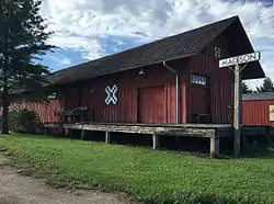 Historic ATSF depot (2016) | |
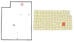 Location within Greenwood County and Kansas | |
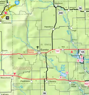 KDOT map of Greenwood County (legend) | |
| Coordinates: 38°07′59″N 96°8′14″W[1] | |
| Country | United States |
| State | Kansas |
| County | Greenwood |
| Founded | 1872 |
| Incorporated | 1885 [2] |
| Named for | Madison Township |
| Government | |
| • Type | Mayor–Council |
| Area | |
| • Total | 0.59 sq mi (1.52 km2) |
| • Land | 0.59 sq mi (1.52 km2) |
| • Water | 0.00 sq mi (0.00 km2) |
| Elevation | 1,145 ft (349 m) |
| Population | |
| • Total | 689 |
| • Density | 1,200/sq mi (450/km2) |
| Time zone | UTC-6 (CST) |
| • Summer (DST) | UTC-5 (CDT) |
| ZIP codes | 66855, 66860 |
| Area code | 620 |
| FIPS code | 20-44050 |
| GNIS ID | 2395809[1] |
| Website | madisonkansas.org |
History
Madison was founded in 1872 northwest of the present town. In 1879, the town was relocated to its present site when the Howard Branch of the Atchison, Topeka & Santa Fe Railroad was built from Emporia to Moline.[5] The first building was the home of W. H. Green, a Civil War veteran. Green came to Kansas in 1867, took up a homestead, and operated a trading post on the original town site.[6] Madison took its name from Madison Township.[7]
Geography
According to the United States Census Bureau, the city has a total area of 0.61 square miles (1.58 km2), all of it land.[8]
Climate
The climate in this area is characterized by hot, humid summers and generally mild to cool winters. According to the Köppen Climate Classification system, Madison has a humid subtropical climate, abbreviated "Cfa" on climate maps.[9]
Demographics
| Census | Pop. | Note | %± |
|---|---|---|---|
| 1880 | 123 | — | |
| 1890 | 623 | 406.5% | |
| 1900 | 683 | 9.6% | |
| 1910 | 721 | 5.6% | |
| 1920 | 795 | 10.3% | |
| 1930 | 1,488 | 87.2% | |
| 1940 | 1,198 | −19.5% | |
| 1950 | 1,212 | 1.2% | |
| 1960 | 1,105 | −8.8% | |
| 1970 | 1,061 | −4.0% | |
| 1980 | 1,099 | 3.6% | |
| 1990 | 845 | −23.1% | |
| 2000 | 857 | 1.4% | |
| 2010 | 701 | −18.2% | |
| 2020 | 689 | −1.7% | |
| U.S. Decennial Census | |||
2010 census
As of the census[10] of 2010, there were 701 people, 313 households, and 190 families living in the city. The population density was 1,149.2 inhabitants per square mile (443.7/km2). There were 401 housing units at an average density of 657.4 per square mile (253.8/km2). The racial makeup of the city was 95.1% White, 0.1% African American, 1.7% Native American, 0.1% Asian, 0.6% from other races, and 2.3% from two or more races. Hispanic or Latino of any race were 2.9% of the population.
There were 313 households, of which 26.5% had children under the age of 18 living with them, 49.8% were married couples living together, 7.3% had a female householder with no husband present, 3.5% had a male householder with no wife present, and 39.3% were non-families. 35.5% of all households were made up of individuals, and 14.3% had someone living alone who was 65 years of age or older. The average household size was 2.24 and the average family size was 3.90
The median age in the city was 42.3 years. 25.1% of residents were under the age of 18; 5.2% were between the ages of 18 and 24; 23.4% were from 25 to 44; 27.8% were from 45 to 64; and 18.3% were 65 years of age or older. The gender makeup of the city was 47.6% male and 52.4% female.
2000 census
As of the census[11] of 2000, there were 857 people, 361 households, and 225 families living in the city. The population density was 1,425.4 inhabitants per square mile (550.4/km2). There were 418 housing units at an average density of 695.2 per square mile (268.4/km2). The racial makeup of the city was 96.27% White, 0.12% African American, 0.93% Native American, 0.12% Asian, 0.47% from other races, and 2.10% from two or more races. Hispanic or Latino of any race were 1.40% of the population.
There were 361 households, out of which 28.8% had children under the age of 18 living with them, 52.9% were married couples living together, 7.2% had a female householder with no husband present, and 37.4% were non-families. 34.3% of all households were made up of individuals, and 21.6% had someone living alone who was 65 years of age or older. The average household size was 2.27 and the average family size was 2.93.
In the city, the population was spread out, with 23.9% under the age of 18, 6.7% from 18 to 24, 23.5% from 25 to 44, 22.9% from 45 to 64, and 23.1% who were 65 years of age or older. The median age was 41 years. For every 100 females, there were 90.0 males. For every 100 females age 18 and over, there were 80.6 males.
The median income for a household in the city was $30,536, and the median income for a family was $40,125. Males had a median income of $25,625 versus $18,333 for females. The per capita income for the city was $15,558. About 9.1% of families and 13.1% of the population were below the poverty line, including 17.8% of those under age 18 and 9.6% of those age 65 or over.
Education
The community is served by Madison–Virgil USD 386 public school district.[12]
The Madison Bulldogs won the Kansas State High School boys class 1A basketball championship in 1976 and the 1A football championship in 1984.[13]
References
- U.S. Geological Survey Geographic Names Information System: Madison, Kansas
- "City of Madison". The League of Kansas Municipalities. May 28, 2019.
- "2019 U.S. Gazetteer Files". United States Census Bureau. Retrieved July 24, 2020.
- "Profile of Madison, Kansas in 2020". United States Census Bureau. Archived from the original on May 6, 2022. Retrieved May 8, 2022.
- Blackmar, Frank Wilson (1912). Kansas: A Cyclopedia of State History, Volume 2. Standard Publishing Company. p. 210.
- kancoll.com |title=Cutler's History of Kansas | publisher=A. T. Andreas, Chicago, Illinois |author=William G. Cutler |year=1883 | page=Part9
- Kansas State Historical Society (1916). Biennial Report of the Board of Directors of the Kansas State Historical Society. Kansas State Printing Plant. p. 199.
- "US Gazetteer files 2010". United States Census Bureau. Archived from the original on January 25, 2012. Retrieved July 6, 2012.
- Climate Summary for Madison, Kansas
- "U.S. Census website". United States Census Bureau. Retrieved July 6, 2012.
- "U.S. Census website". United States Census Bureau. Retrieved January 31, 2008.
- "Madison-Virgil USD 386". USD 386. Retrieved January 6, 2017.
- "Basketball". KSHSAA. Retrieved January 3, 2017.
Further reading
External links
- City of Madison
- Madison - Directory of Public Officials
- Saving A Town, One Business At A Time on YouTube, from Hatteberg's People on KAKE TV news
- Madison city map, KDOT
Municipalities and communities of Greenwood County, Kansas, United States | ||
|---|---|---|
| Cities |  Map of Kansas highlighting Greenwood County | |
| Unincorporated communities | ||
| Ghost towns | ||
| Townships | ||
| Footnotes | †This community is designated a Census-Designated Place (CDP) by the United States Census Bureau. | |