Lukla
Lukla (Nepali: लुक्ला [ˈlukla]) is a small town in the Khumbu Pasanglhamu rural municipality of the Solukhumbu District in the Province No. 1 of north-eastern Nepal. Situated at 2,860 metres (9,383 ft), it is a popular place for visitors to the Himalayas near Mount Everest to arrive. Although Lukla means "place with many goats and sheep", few are found in the area nowadays.
Lukla | |
|---|---|
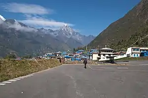 Looking across the township of Lukla, with the air strip of Lukla Airport in the foreground | |
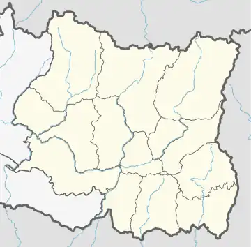 Lukla Location in Nepal  Lukla Lukla (Nepal) | |
| Coordinates: 27°41′20″N 86°43′50″E | |
| Country | |
| Province | Province No. 1 |
| District | Solukhumbu District |
| Rural municipality | Khumbu Pasanglhamu |
| Government | |
| • Type | Ward division |
| Elevation | 2,860 m (9,380 ft) |
| Time zone | UTC+5:45 (Nepal Time) |
| Postal code | 56010 |
| Area code | 038 |
Lukla contains a small airport serving the region, and a variety of shops and lodges catering to tourists and trekkers, providing western-style meals and trail supplies. From Lukla, travellers need two days to reach the village of Namche Bazaar, an altitude-acclimatization stop for those continuing on.[1] In August 2014, the Nepalese government announced plans to open the first tarmac road from Kathmandu to Lukla.[2]
Airport
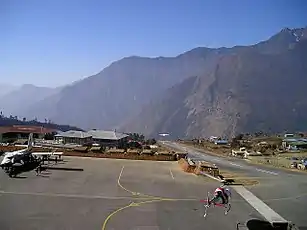
Lukla is served by the Tenzing-Hillary Airport. Weather permitting, twin-engined Dornier 228s and de Havilland Canada Twin Otters make frequent daylight flights between Lukla and Kathmandu. Lukla Airport has a very short and steep airstrip, often compounded by hazardous weather, resulting in several fatal accidents. It has been called the most dangerous airport in the world.[4][3]
Climate
| Climate data for Lukla (Chaurikharka, elevation 2,619 m (8,593 ft)) | |||||||||||||
|---|---|---|---|---|---|---|---|---|---|---|---|---|---|
| Month | Jan | Feb | Mar | Apr | May | Jun | Jul | Aug | Sep | Oct | Nov | Dec | Year |
| Average high °C (°F) | 9.8 (49.6) |
11.0 (51.8) |
13.7 (56.7) |
18.1 (64.6) |
19.2 (66.6) |
19.5 (67.1) |
19.3 (66.7) |
19.6 (67.3) |
18.4 (65.1) |
17.5 (63.5) |
14.0 (57.2) |
11.3 (52.3) |
16.0 (60.7) |
| Average low °C (°F) | −1.5 (29.3) |
−0.2 (31.6) |
3.0 (37.4) |
6.1 (43.0) |
8.3 (46.9) |
11.3 (52.3) |
12.2 (54.0) |
11.7 (53.1) |
10.6 (51.1) |
7.1 (44.8) |
2.3 (36.1) |
−0.4 (31.3) |
5.9 (42.6) |
| Average precipitation mm (inches) | 18.3 (0.72) |
30.3 (1.19) |
27.0 (1.06) |
60.1 (2.37) |
106.7 (4.20) |
321.5 (12.66) |
583.1 (22.96) |
570.1 (22.44) |
297.7 (11.72) |
63.6 (2.50) |
13.0 (0.51) |
14.7 (0.58) |
2,106.1 (82.91) |
| Source 1: ANU[5] | |||||||||||||
| Source 2: Agricultural Extension in South Asia (precipitation 1976–2005)[6] | |||||||||||||
References
- Muza, SR; Fulco, CS; Cymerman, A (2004). "Altitude Acclimatization Guide". US Army Research Inst. Of Environmental Medicine Thermal and Mountain Medicine Division Technical Report (USARIEM–TN–04–05). Archived from the original on April 23, 2009. Retrieved 2009-03-05.
{{cite journal}}: CS1 maint: unfit URL (link) - Wright, Loveday (13 August 2014). "Highway to Everest: infrastructure at the expense of nature? | Asia | An in-depth look at news from across the continent". DW. Retrieved 13 November 2020.
- "Which Everest Base Camp is Best:Tibet or Nepal?". 30 June 2019.
- "World's Most Dangerous Airports". Retrieved 2011-03-25.
- "CLIMATES OF NEPAL AND THEIR IMPLICATIONS FOR AGRICULTURAL DEVELOPMENT" (PDF). Australian National University. Archived from the original (PDF) on 23 October 2023. Retrieved 23 October 2023.
- "TEMPORAL AND SPATIAL VARIABILITY OF CLIMATE CHANGE OVER NEPAL (1976-2005)" (PDF). Agricultural Extension in South Asia. Archived from the original (PDF) on 13 October 2023. Retrieved 27 October 2023.