Llano Quemado, New Mexico
Llano Quemado is an unincorporated community and former census-designated place in Taos County, New Mexico, United States,[1] situated immediately southwest of Ranchos De Taos.[2]
Llano Quemado, New Mexico | |
|---|---|
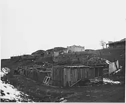 Llano Quemado, December 1941 | |
| Coordinates: 36°20′28″N 105°36′51″W | |
| Country | United States |
| State | New Mexico |
| County | Taos |
| Elevation | 8,179 ft (2,493 m) |
| Time zone | UTC-7 (Mountain (MST)) |
| • Summer (DST) | UTC-6 (MDT) |
| ZIP codes | 87557 |
| GNIS feature ID | 2629117[1] |
See also
References
- "Llano Quemado". Geographic Names Information System. United States Geological Survey, United States Department of the Interior.
- Google (October 15, 2021). "Llano Quemado, New Mexico 87557" (Map). Google Maps. Google. Retrieved October 15, 2021.
External links
![]() Media related to Llano Quemado, New Mexico at Wikimedia Commons
Media related to Llano Quemado, New Mexico at Wikimedia Commons
Municipalities and communities of Taos County, New Mexico, United States | ||
|---|---|---|
| Towns |  Map of New Mexico highlighting Taos County | |
| Villages | ||
| CDPs | ||
| Other communities | ||
| Ghost towns | ||
| Indian reservation | ||
| Footnotes | ‡This populated place also has portions in an adjacent county or counties | |
This article is issued from Wikipedia. The text is licensed under Creative Commons - Attribution - Sharealike. Additional terms may apply for the media files.