List of mountains in Liechtenstein

This is a list of mountains of Liechtenstein, they are all within the Rätikon range of the Eastern Alps.

List of mountains in Liechtenstein is located in Liechtenstein
Falknis
Falknis
Mittlerspitz
Mittlerspitz
Mittagspitz
Mittagspitz
Koraspitz
Koraspitz
Goldlochspitz
Goldlochspitz
Kulmi
Kulmi
Plasteikopf
Plasteikopf
Kuhgrat
Kuhgrat
Gamsgrat
Gamsgrat
Rauher Berg
Rauher Berg
Scheienkopf
Scheienkopf
Zigerbergkopf
Zigerbergkopf
Garsellikopf
Garsellikopf
Sarojahöhe
Sarojahöhe
Mauerer Berg
Mauerer Berg
Helwangspitz
Helwangspitz
Alpspitz
Alpspitz
Gafleispitz
Gafleispitz
Stachlerkopf
Stachlerkopf
Drei Kapuziner
Drei Kapuziner
Spitz
Spitz
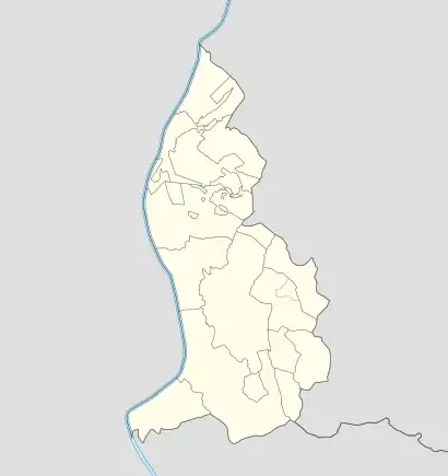
Distribution of Liechtenstein's mountains
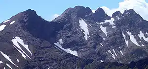
The ridge on the border of Liechtenstein and Switzerland containing Vorder and Hinter Grauspitz
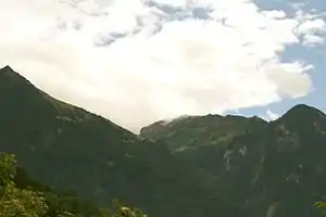
Koraspitz, Mazorakopf and Mittlerspitz (left to right)
NameHeightCoordinates
Naafkopf2570 m [1]47°3′38.54″N 9°36′25.75″E
Schwarzhorn2574 m [1]47°3′17.4″N 9°35′17″E
Grauspitz2599 m [1]47°3′10″N 9°34′55″E
Falknis2560 m [1]47°3′1.9″N 9°33′52.3″E
Falknishorn (Mazorakopf)2451 m [1]47°2′54.52″N 9°33′25.17″E
Mittlerspitz1897 m [1]47°3′54″N 9°32′23″E
Mittagspitz1857 m [1]47°4′9″N 9°32′3″E
Koraspitz1927 m [1]47°4′45″N 9°33′28″E
Langspitz2006 m [1]47°4′43.7″N 9°33′43.1″E
Goldlochspitz2110 m [1]47°4′57″N 9°34′2″E
Kulmi[2] / Kolme[1]1993 m47°5′15″N 9°34′20″E
Heubühl1936 m [1]47°5′46″N 9°34′0.9″E
Plasteikopf2356 m [1]47°3′55″N 9°34′38″E
Augstenberg2359 m [1]47°4′57″N 9°36′36″E
Gamsgrat2201 m [1]47°6′38″N 9°37′14″E
Ochsenkopf2286 m [1]47°6′53″N 9°37′28″E
Scheienkopf2159 m [1] (summit in Austria)47°7′43″N 9°38′8″E
Stachlerkopf2071 m [1]47°7′18.6″N 9°35′32.5″E
Schönberg2104 m [1]47°7′49.3″N 9°35′34.6″E
Galinakopf2198 m [1]47°9′6″N 9°37′14″E
Kuhgrat (Kuegrat)2123 m [1]47°10′0″N 9°34′0″E
Garsellakopf (Garsellikopf)2105 m [1]47°10′13″N 9°33′53″E
Drei Schwestern2052 m [1]47°10′32″N 9°34′22″E
Sarojahöhe (Saroja)1659 m [1]47°11′27″N 9°34′21″E
Gafleispitz2000 m [1]47°9′31″N 9°33′17″E
Alpspitz1942 m [1]47°8′55″N 9°33′14″E
Helwangspitz2000 m [1]47°8′55″N 9°33′44″E
Gorfion2308 m [2]47°4′41″N 9°37′7″E
Silberhorn[3] / Hubel[2]2150 m47°5′14.7″N 9°36′20.1″E
Nospitz2091 m [2]47°5′35.3″N 9°35′54.1″E
Rappenstein2221 m [2]47°4′35″N 9°34′0″E
Rotspitz2127 m [2]47°3′30″N 9°33′5″E
Würznerhorn1713 m [2]47°3′46″N 9°31′52″E
Sattelköpfle1688 m [2]47°11′8.3″N 9°34′23.7″E
Zigerbergkopf2051 m [2]47°9′4″N 9°36′12″E
Kirchlespitz1929 m [2]47°6′11.7″N 9°35′21″E
Spitz2186 m [2]47°5′12.3″N 9°37′26.5″E
Maurerberg[1] / Mauerer Berg[2]1378 m47°12′18″N 9°35′5″E
Rauher Berg2094 m[2]47°6′27″N 9°37′42″E
Drei Kapuziner2084 m[2]47°7′27.9″N 9°35′20″E

References

  1. Unfolding Liechtenstein, Panorama Map (Map). Liechtenstein Tourismus. 2007.
  2. Feldkirch - Vaduz (Map). 1:50000. Wander, Bike- und Skitourenkarte. Cartography by Kompass-Karten GmbH. Kompass. 2007.
  3. Schesaplana (Map). 1:25000. Landeskarte der Schweiz. swisstopo. 2004.
This article is issued from Wikipedia. The text is licensed under Creative Commons - Attribution - Sharealike. Additional terms may apply for the media files.