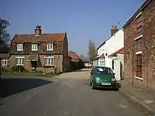
Lelley
Lelley is a small village in the East Riding of Yorkshire, England, in an area known as Holderness. It is situated approximately 7 miles (11 km) north-east of Hull city centre and 3 miles (5 km) north of Hedon.

| Lelley | |
|---|---|
| Village | |
 Lelley Location within the East Riding of Yorkshire | |
| OS grid reference | TA209325 |
| • London | 155 mi (249 km) S |
| Civil parish | |
| Unitary authority | |
| Ceremonial county | |
| Region | |
| Country | England |
| Sovereign state | United Kingdom |
| Post town | HULL |
| Postcode district | HU12 |
| Dialling code | 01482 |
| Police | Humberside |
| Fire | Humberside |
| Ambulance | Yorkshire |
| UK Parliament | |
The village forms part of the civil parish of Elstronwick.[1]
Lelley comes from the word 'Lelle' which means 'clearing in the woods'.[2]
The village contains a public house, two benches (one a war memorial and the other a millennium bench) and a telephone box.
Lelley Wesleyan Methodist Church was built in the village in 1859.[3]
In 1823 Lelly was in the parish of Preston and the Wapentake and Liberty of Holderness. Population was 119, which included a carrier who operated between the village and Hull once a week.[4]
The Lelley Windmill, a six-storey corn mill completed in 1790, is a Grade II* Listed Building.[5]
References
- UK Census (2011). "Local Area Report – Elstronwick Parish (E04000388)". Nomis. Office for National Statistics. Retrieved 5 December 2022.
- "Lelley :: Survey of English Place-Names". epns.nottingham.ac.uk. Retrieved 5 December 2022.
- Kelly's Directory of Hull, 1899. Hull: Kelly's. 1899. p. 597. OCLC 1131686686.
- Baines, Edward (1823): History, Directory and Gazetteer of the County of York, p. 363
- Historic England. "Lelley Windmill, Elstonwick (1215991)". National Heritage List for England. Retrieved 31 December 2021.
- Gazetteer — A–Z of Towns Villages and Hamlets. East Riding of Yorkshire Council. 2006. p. 7.