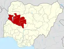
Lavun
Lavun is a Local Government Area in Niger State, Nigeria. Its headquarters is located in the town of Kutigi in the south of the area at9°12′00″N 5°36′00″E. The Kaduna River forms the eastern border of the Local Government Area.
Lavun | |
|---|---|
| Nickname: Biggsx | |
 Lavun Location in Nigeria | |
| Coordinates: 9°27′N 5°38′E | |
| Country | |
| State | Niger State |
| Government | |
| • Local Government Chairman and the Head of the Local Government Council | Alhaji Limanko pata |
| Area | |
| • Total | 2,835 km2 (1,095 sq mi) |
| Population (2006 census) | |
| • Total | 209,917 |
| Time zone | UTC+1 (WAT) |
| 3-digit postal code prefix | 912 |
| ISO 3166 code | NG.NI.LV |
It has an area of 2,835 km2 and a population of 209,917 at the 2006 census. The postal code of the area is 913.[1]
Geography /Climate
Lavun Local Government Area is 2,835 square kilometers in size and has average temperatures of 31 degrees centigrade. The Local Government Area, which is located along the Kaduna River, has an average humidity of 39%. Lavun Local Government Area's estimated 10 km/h average wind speed.[2][3]
Notable people from Lavun
- Shaikh Ahmad Lemu (OON, OFR), Islamic Scholar (1929–2020)
- Hon. Justice Idris Legbo Kutigi (OFR, GCON), Nigeria Lawyer and Judge (1939–2018)
- Professor Jerry Gana Busu (CON), Nigeria Senator and Minister
References
- "Post Offices- with map of LGA". NIPOST. Archived from the original on 2012-11-26. Retrieved 2009-10-20.
- "Lavun Local Government Area". www.manpower.com.ng. Retrieved 2023-09-27.
- Vizzuality. "Lavun, Niger, Nigeria Deforestation Rates & Statistics | GFW". www.globalforestwatch.org. Retrieved 2023-09-27.
This article is issued from Wikipedia. The text is licensed under Creative Commons - Attribution - Sharealike. Additional terms may apply for the media files.
