Lastours
Lastours (Occitan: Las Tors) is a commune in the Aude department in southern France.
Lastours | |
|---|---|
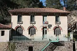 The town hall in Lastours | |
.svg.png.webp) Coat of arms | |
Location of Lastours | |
 Lastours  Lastours | |
| Coordinates: 43°20′06″N 2°22′47″E | |
| Country | France |
| Region | Occitania |
| Department | Aude |
| Arrondissement | Carcassonne |
| Canton | La Vallée de l'Orbiel |
| Government | |
| • Mayor (2020–2026) | Max Brail[1] |
| Area 1 | 2.80 km2 (1.08 sq mi) |
| Population | 155 |
| • Density | 55/km2 (140/sq mi) |
| Time zone | UTC+01:00 (CET) |
| • Summer (DST) | UTC+02:00 (CEST) |
| INSEE/Postal code | 11194 /11600 |
| Elevation | 163–383 m (535–1,257 ft) (avg. 180 m or 590 ft) |
| 1 French Land Register data, which excludes lakes, ponds, glaciers > 1 km2 (0.386 sq mi or 247 acres) and river estuaries. | |
Lastours is located 12 km (7.5 mi) outside Carcassonne, in the valley of the Orbiel. There are four small castles each built on a large 300 m high rocky ridge. The castles were built to control the access to Montagne Noire and the Cabardes region. These are some of the few original Cathar castles left.
Population
| Year | Pop. | ±% |
|---|---|---|
| 1962 | 439 | — |
| 1968 | 444 | +1.1% |
| 1975 | 300 | −32.4% |
| 1982 | 248 | −17.3% |
| 1990 | 159 | −35.9% |
| 1999 | 163 | +2.5% |
| 2008 | 165 | +1.2% |
See also
References
- "Répertoire national des élus: les maires". data.gouv.fr, Plateforme ouverte des données publiques françaises (in French). 2 December 2020.
- "Populations légales 2020". The National Institute of Statistics and Economic Studies. 29 December 2022.
Wikimedia Commons has media related to Lastours.
This article is issued from Wikipedia. The text is licensed under Creative Commons - Attribution - Sharealike. Additional terms may apply for the media files.