Larochette
Larochette (French pronunciation: [laʁɔʃɛt]; Luxembourgish: Fiels, German: Fels) is a commune and town in central Luxembourg, in the canton of Mersch. It is situated on the White Ernz river. The town is dominated by the partly ruined Larochette Castle.
Larochette
Fiels | |
|---|---|
 | |
 Coat of arms | |
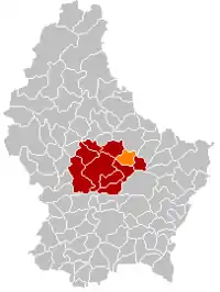
 Map of Luxembourg with Larochette highlighted in orange, and the canton in dark red | |
| Coordinates: 49.783611°N 6.219444°E | |
| Country | |
| Canton | Mersch |
| Area | |
| • Total | 15.4 km2 (5.9 sq mi) |
| • Rank | 74th of 102 |
| Highest elevation | 420 m (1,380 ft) |
| • Rank | 36th of 102 |
| Lowest elevation | 266 m (873 ft) |
| • Rank | 70th of 102 |
| Population | |
| • Total | 2,208 |
| • Rank | 67th of 102 |
| • Density | 140/km2 (370/sq mi) |
| • Rank | 52nd of 102 |
| Time zone | UTC+1 (CET) |
| • Summer (DST) | UTC+2 (CEST) |
| LAU 2 | LU0000406 |
| Website | larochette.lu |
The town of Larochette lies in the north-east of the commune. Other towns within the commune include Ernzen.
Meysembourg Castle, located some 2 kilometres (1+1⁄4 mi) south-west of Larochette, has a history dating back to the 12th century. Today's castle was built in 1880 in Neo-Renaissance style and is privately owned.[1]
Geography
The settlements of the commune lie in the valley of the White Ernz into which the commune's streams Ousterbur, Manzebaach and Iernzerbaach run. The valley is surrounded by Luxembourg Sandstone and small areas of Steinmergelkeuper.[2]
History
The town of Larochette used to be a small industrial hub. It was specialised in cloth mills on the river White Ernz from the end of the 18th century until the 1930s with some factories being active until the 1980s.
In the street Rue de Medernach was a spinning factory, which became a brush factory from the 1920s to 1986 and is nowadays an apartment complex.[3][4] At the location of today's primary school and cultural center on the same road used to be an industrial complex with different industrial uses over the years.[5][6] In the Rue Scheerbach were several textile factories that are now residential buildings, one of the industrial chimneys has been restored.[7][8] Other remnants can be seen in a museum in a building of the former train station.[9]
Larochette was part of the narrow-gauge railway Larochette - Cruchten that was operational from 1882 to 1948. It was also connected to another narrow-gauge railway that went to the quarries in Ernzen over Heffingen-Soup. The planned connection to Junglinster was never finished. Still visible today are the train station buildings of Larochette, a train depot that is nowadays a petrol station and supermarket, as well as several bridges. Many sections are now part of the national cycle path network.[10][11]
Population
Gallery
References
- "Le Château de Meysembourg - Larochette", Larochette: Syndicat d'initiative et de tourisme (in French) Retrieved 21 March 2011.
- "Carte géologique harmonisée". geoportail.lu. Retrieved 3 February 2022.
- "Spinnerei Follmillen - Follmühle". Retrieved 3 February 2022.
- "Brosserie Moderne Fabrola Follmühle". Retrieved 3 February 2022.
- "Jean Sinner - Even". Retrieved 3 February 2022.
- "Bonne - Schmitz & Cie". Retrieved 3 February 2022.
- "Draperies de Larochette". Retrieved 3 February 2022.
- "Vestimenta S.A." Retrieved 3 February 2022.
- "Industry Museum - Larochette". Retrieved 3 February 2022.
- "Ligne Cruchten - Larochette". Retrieved 3 February 2022.
- "Ligne Larochette - Heffingen - Carrières d'Ernzen". Retrieved 3 February 2022.
- "Population par canton et commune". statistiques.public.lu. Retrieved 11 January 2022.
External links
 Media related to Larochette at Wikimedia Commons


