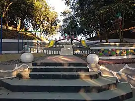
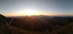
Lalsavunga Park
Lalsavunga Park is a tourist spot near Aizawl, Mizoram. It is about 18 km from Aizawl in South Hlimen. It is at an elevation of 1179 metres.[1][2]
| Lalsavunga Park | |
|---|---|
 | |
| Highest point | |
| Elevation | 1,179 m (3,868 ft) |
| Coordinates | 23.671606°N 92.7180847°E |
| Geography | |
| Location | South Hlimen Aizawl District, Mizoram, India |
| Parent range | Lushai Hills |
History
Lalsavunga Park Bridge
Lalsavunga Park construction started in 2014[3] with an estimated expenditure of 464 lakhs.[4] The area of the park is 120 acres and the mountain range is 1 km long. The park was opened on 3 October 2018.[5]

References
- "MOUNTAINS IN MIZORAM" (PDF). ide.go. Retrieved 8 January 2019.
- "MOUNTAINS IN MIZORAM" (PDF). Shodhganga. Retrieved 8 January 2019.
- "Lalsavunga Park hawng". Lunglen. Retrieved 29 November 2018.
- "Local Administration Department-in Hlimen Zophei rama Lalsavunga Park a siam chu Chief Minister, Pu Lal Thanhawla'n nimin khan a hawng". Zonet. Retrieved 29 November 2018.
- "CM-in Lalsavunga Park a hawng". Vanglaini. Retrieved 29 November 2018.
- "Lalsavunga Park - Hlimen". Mizoram Panaroma. Retrieved 7 November 2022.
External links
Wikimedia Commons has media related to Lalsavunga Park.
Wikivoyage has a travel guide for Aizawl.
- Google. "Lalsavunga Park" (Map). Google Maps. Google.
| State symbols | |
|---|---|
| Government | |
| Topics | |
| Districts | |
| Urban Areas | |
| Infrastructure | |
| Education | |
| Tourism | |
| Protected areas | |
| Mizo Culture | |
This article is issued from Wikipedia. The text is licensed under Creative Commons - Attribution - Sharealike. Additional terms may apply for the media files.