Lake Timberline, Missouri
Lake Timberline is an unincorporated community and census-designated place (CDP) in St. Francois County, Missouri, United States. The community is built around several reservoirs built in the valleys of Bee Run and Primrose Creek, southwest-flowing tributaries of the Big River, which in turn flows northwest to the Meramec River.
Lake Timberline, Missouri | |
|---|---|
 Lake Timberline  Lake Timberline | |
| Coordinates: 37°59′45″N 90°32′44″W | |
| Country | United States |
| State | Missouri |
| County | St. Francois |
| Townships | Big River |
| Area | |
| • Total | 2.57 sq mi (6.65 km2) |
| • Land | 2.38 sq mi (6.16 km2) |
| • Water | 0.19 sq mi (0.49 km2) |
| Elevation | 850 ft (260 m) |
| Population (2020) | |
| • Total | 726 |
| • Density | 305.30/sq mi (117.87/km2) |
| Time zone | UTC-6 (Central (CST)) |
| • Summer (DST) | UTC-5 (CDT) |
| ZIP Code | 63628 (Bonne Terre) |
| Area code | 573 |
| FIPS code | 29-40222 |
| GNIS feature ID | 2806427[2] |
The community is in northern St. Francois County, bordered to the north by Jefferson County. It is northwest of U.S. Route 67, 6 miles (10 km) north of Bonne Terre, 19 miles (31 km) southwest of Festus, and 53 miles (85 km) southwest of St. Louis.
The community was first listed as a CDP prior to the 2020 census.[2]
References
- "ArcGIS REST Services Directory". United States Census Bureau. Retrieved August 28, 2022.
- "Lake Timberline Census Designated Place". Geographic Names Information System. United States Geological Survey, United States Department of the Interior.
- "Census of Population and Housing". Census.gov. Retrieved June 4, 2016.
Municipalities and communities of Saint Francois County, Missouri, United States | ||
|---|---|---|
| Cities | 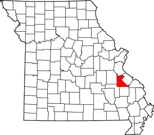 Map of Missouri highlighting Saint Francois County | |
| Townships | ||
| CDPs | ||
| Other communities | ||
| Ghost towns | ||
| Footnotes | ‡This populated place also has portions in an adjacent county or counties | |
This article is issued from Wikipedia. The text is licensed under Creative Commons - Attribution - Sharealike. Additional terms may apply for the media files.