La Chapelle-du-Mont-de-France
La Chapelle-du-Mont-de-France is a commune in the Saône-et-Loire department in the region of Bourgogne-Franche-Comté in eastern France.
La Chapelle-du-Mont-de-France | |
|---|---|
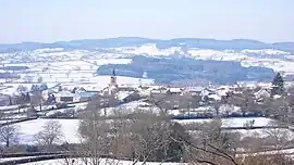 A general view of La Chapelle-du-Mont-de-France | |
Location of La Chapelle-du-Mont-de-France | |
 La Chapelle-du-Mont-de-France  La Chapelle-du-Mont-de-France | |
| Coordinates: 46°22′58″N 4°32′12″E | |
| Country | France |
| Region | Bourgogne-Franche-Comté |
| Department | Saône-et-Loire |
| Arrondissement | Mâcon |
| Canton | La Chapelle-de-Guinchay |
| Intercommunality | Saint-Cyr Mère Boitier entre Charolais et Mâconnais |
| Government | |
| • Mayor (2020–2026) | Philippe Hilarion[1] |
| Area 1 | 9.11 km2 (3.52 sq mi) |
| Population | 192 |
| • Density | 21/km2 (55/sq mi) |
| Time zone | UTC+01:00 (CET) |
| • Summer (DST) | UTC+02:00 (CEST) |
| INSEE/Postal code | 71091 /71520 |
| Elevation | 294–546 m (965–1,791 ft) (avg. 314 m or 1,030 ft) |
| 1 French Land Register data, which excludes lakes, ponds, glaciers > 1 km2 (0.386 sq mi or 247 acres) and river estuaries. | |
References
- "Répertoire national des élus: les maires" (in French). data.gouv.fr, Plateforme ouverte des données publiques françaises. 13 September 2022.
- "Populations légales 2020". The National Institute of Statistics and Economic Studies. 29 December 2022.
Wikimedia Commons has media related to La Chapelle-du-Mont-de-France.
This article is issued from Wikipedia. The text is licensed under Creative Commons - Attribution - Sharealike. Additional terms may apply for the media files.