Kushtia
Kushtia (Bengali: কুষ্টিয়া) is a city in the Khulna Division of southwestern Bangladesh. Kushtia is the second largest municipality in Bangladesh and the eleventh largest city in the country. The second largest city in Khulna division. It is one of the commercial cities.[6] It serves as the headquarters of Kushtia Sadar Upazila and Kushtia District.[3]
Kushtia
কুষ্টিয়া | |
|---|---|
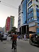
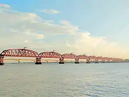
 .jpg.webp)     from top: Kushtia city skyline, Porimol Tower, Lovely Tower, Tomb of Lalon, Tagore kuthibari, Hardinge Bridge | |
 Kushtia Location in Bangladesh | |
| Coordinates: 23.910125°N 89.123115°E | |
| Country | |
| Division | Khulna Division |
| District | Kushtia District |
| Subdistrict | Kushtia Sadar Upazila |
| Municipality | 1 April 1869 [1] |
| Government | |
| • Type | Mayor–Council |
| • Body | Kushtia Municipality |
| • Paura Mayor | Md. Anwar Ali [2] |
| Area | |
| • Urban | 66.00 km2 (25.48 sq mi) |
| • Metro | 120.23 km2 (46.42 sq mi) |
| Population (2018 [4]) | |
| • Urban | 418,312 |
| • Urban density | 6,300/km2 (16,000/sq mi) |
| • Metro | 550,000 |
| • Metro density | 4,600/km2 (12,000/sq mi) |
| • Rank | 13th |
| Time zone | UTC+6 (Bangladesh Time) |
| Postal code | 7000[5] |
| National Dialing Code | +880 |
Education
Bheramara Pilot High School (1918) ,Dinmani Secondary School (1930), Kushtia Zilla School (1960), Kumarkhali M N High School and Mohini Mohan High School (1944) are notable secondary schools.[3] [7]
Popular places
- Shelaidaha Kuthi Bari
- The shrine of Lalon fakir
- A Mughal style mosque from Jhaudia
- Explore Jugia Tati Para
- Tagore lodge
- Mighty river Padma
- Gorai river beside the town
- A Christian Cemetery in town
- Kamrul Islam Siddiqui Park
- Hardinge Bridge
- Municipal Museum
- Lalon Shah Bridge
- Chapaigachi Beel
References
- "History of Kushtia municipality". Retrieved 2019-10-07.
- "Mayor of Kushtia city's civic body". News24.com. Retrieved 2019-10-07.
- Bhuiyan, Md Abu Taher (2012). "Kushtia Sadar Upazila". In Islam, Sirajul; Jamal, Ahmed A. (eds.). Banglapedia: National Encyclopedia of Bangladesh (Second ed.). Asiatic Society of Bangladesh.
- "কুষ্টিয়া পৌরসভা". municipality.kushtia.gov.bd.
- Staff. "ZIP Code database of Bangladesh". Geopostcodes.com. Retrieved 11 June 2008.
- "NGA GeoNames Database". National Geospatial-Intelligence Agency. Retrieved 2 January 2015.
- "Home". kumarkhalimnsecondaryschool.jessoreboard.gov.bd.
This article is issued from Wikipedia. The text is licensed under Creative Commons - Attribution - Sharealike. Additional terms may apply for the media files.