Kusada
Kusada is a Local Government Area in Katsina State, Nigeria. Its headquarters is located in the town of Kusada.
Butulu of kusada | |
|---|---|
LGA and town | |
| Kusada | |
| Motto: Kusada Garin Malamai | |
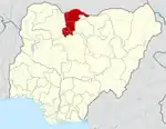
 Butulu of kusada Location in Nigeria | |
| Coordinates: 12°28′N 7°59′E | |
| Country | |
| State | Katsina State |
| Established | 1996 |
| Government | |
| • House of Representatives | Abubakar Yahya Kusada |
| Area | |
| • Total | 390 km2 (150 sq mi) |
| Population (2006 census) | |
| • Total | 199,267 |
| Time zone | UTC+1 (WAT) |
| 3-digit postal code prefix | 833 |
| ISO 3166 code | NG.KT.KD |
The major ethnic groups are Hausa and Fulani.
Its major Villages includes: Kafarda, Dudunni, Dangamau, Yashe, Mawashi, Kofa, Kaikai. The people of Kusada local government are mostly farmers and herdsmen. Their standard of living is well improved as the government had since provided them with social amenities such as, Schools, Hospitals, good tarred roads, boreholes (both manual and solar system), farm boreholes, dams, well organized local markets etc.
Both government boarding and day Secondary and Primary Schools, are located in the town and some major villages in the local government. The local government is also characterized with government residential area, beautiful jumu'at mosques, good township roads and well named and numbered streets.
It has an area of 390 km2 and a population of 199,267 at the 2006 census.
The postal code of the area is 833.[1]
Economy
The people that live in Kusada Local Government Area's are involved in a variety of economic pursuits, such as farming and raising animals. The Local Government Area has multiple marketplaces where a wide variety of commodities are bought and sold, contributing to the area's booming trade.[2]
Geography
The overall area of Kusada Local Government Area's is 390 square kilometres, and its average temperature is 34 degrees Celsius. There are two distinct seasons in the area: the dry season and the rainy season. In Kusada Local government area's, the average wind speed is 9 km/h.[3]
Business information
References
- "Post Offices- with map of LGA". NIPOST. Archived from the original on 2012-11-26. Retrieved 2009-10-20.
- "Kusada Local Government Area". www.manpower.com.ng. Retrieved 2023-10-27.
- "Kusada Local Government Area". www.manpower.com.ng. Retrieved 2023-10-27.
- "Kusada Local Government Area". www.finelib.com. Retrieved 2023-10-27.
State capital: Katsina | ||
| Topics |
|  |
| LGAs | ||