King Arthur Park, Montana
King Arthur Park is a census-designated place (CDP) in Gallatin County, Montana, United States. The population was 738 at the 2010 census.[3]
King Arthur Park, Montana | |
|---|---|
 King Arthur Park  King Arthur Park | |
| Coordinates: 45°40′5″N 111°7′43″W | |
| Country | United States |
| State | Montana |
| County | Gallatin |
| Area | |
| • Total | 0.47 sq mi (1.21 km2) |
| • Land | 0.46 sq mi (1.20 km2) |
| • Water | 0.01 sq mi (0.01 km2) |
| Elevation | 4,843 ft (1,476 m) |
| Population (2020) | |
| • Total | 1,549 |
| • Density | 3,345.57/sq mi (1,292.74/km2) |
| Time zone | UTC-7 (Mountain (MST)) |
| • Summer (DST) | UTC-6 (MDT) |
| Area code | 406 |
| FIPS code | 30-40685 |
| GNIS feature ID | 2583820[2] |
References
- "ArcGIS REST Services Directory". United States Census Bureau. Retrieved September 5, 2022.
- U.S. Geological Survey Geographic Names Information System: King Arthur Park, Montana
- "U.S. Census website". United States Census Bureau. Retrieved May 14, 2011.
- "Census of Population and Housing". Census.gov. Retrieved June 4, 2016.
Municipalities and communities of Gallatin County, Montana, United States | ||
|---|---|---|
| Cities | 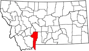 Gallatin County map | |
| Towns | ||
| CDPs | ||
| Other communities | ||
| Footnotes | ‡This populated place also has portions in an adjacent county or counties | |
This article is issued from Wikipedia. The text is licensed under Creative Commons - Attribution - Sharealike. Additional terms may apply for the media files.